Anand Inamdar: Highlights 2015
Reference Environmental Data Records
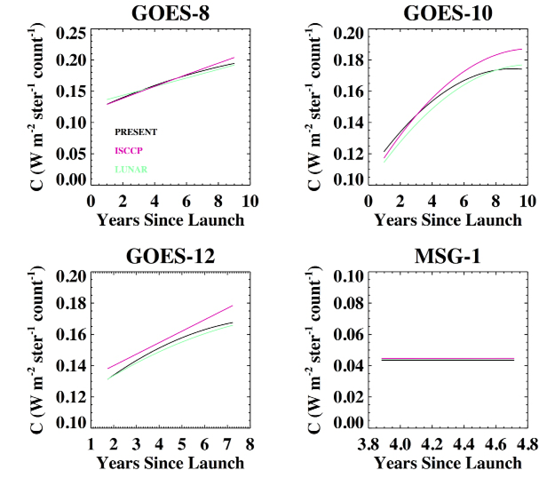
 Calibration for the Geostationary Operational Environmental Satellite (GOES) series for the extended period of 2010–2015 (Figure 1) has been completed. Results compared favorably with the ISCCP and previous calibration and a paper has been published on the calibration of the visible channel of the ISCCP (International Satellite Cloud Climatology Project) B1U data.
- Calibration of the visible channel for the full GOES series of satellites has been processed separately and delivered for the Global Geostationary Surface Albedo project (PI is Jessica Matthews);
- Extensive support for the transition of the ISCCP project to NCEI. The latest version of the ISCCP processing code, Build 5, was delivered and implemented in September 2015, and has undergone several modifications and upgrades over the past year. Major contributions included:
- Development of software packages for the automated Quality Control (QC) of the ISCCP B1 and AVHRR Global Area Coverage (GAC) data, which are core inputs in the generation of the next generation H-series ISCCP cloud products;
- Visual inspection of the ISCCP B1 and AVHRR GAC imagery for the full base period (1983–2009) has been completed;
- Delivery of fully documented code to perform calibration of ISCCP B1 data to the ISCCP team for inclusion in the H-series production catalogue;
- Scientific analysis of the ISCCP H-series products from Build 5 runs commenced recently.
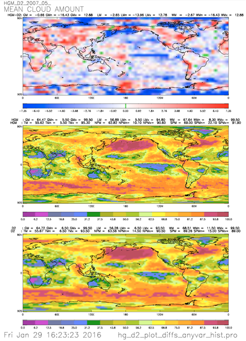
Map of monthly mean cloud amount for 2007 May derived from the ISCCP H-series run (middle panel), its predecessor D-series (bottom panel), and the difference (top panel).