1928
Tropical Depression UNNAMED (1928042S18072)
IBTrACS version v04r01. Visit
IBTrACS website for data access.
Please direct all questions to the
IBTrACS Q and A forum
Storm track
-
Intensity
-
Wind Radii
-
Intensity Data
-
Source Data
-
All data
Summary Information
|
|
| Storm ID |
1928042S18072 |
| Start |
Feb 11 00Z |
| Max Intensity |
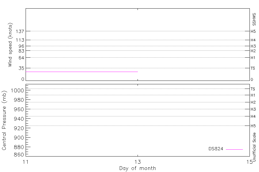
25 kt (Feb 11 03Z) |
| End |
Feb 13 00Z |
| ATCF IDs |
|
| Track status |
Best track data. |
|
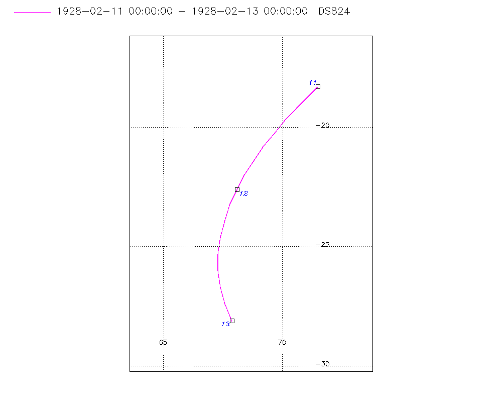
Storm track plot
|
Intensity plots
|
Radial wind information
No radial wind information for this storm
|
Position and Intensity Table
| BASIN |
ISO_TIME_________ |
NATURE |
LAT |
LON |
DS824 WIND |
| |
|
|
degrees north |
degrees east |
kts |
| SI |
1928-02-11 00:00:00 |
TS |
-18.30 |
71.50 |
25 |
| SI |
03:00:00 |
TS |
-18.70 |
71.10 |
25 |
| SI |
06:00:00 |
TS |
-19.20 |
70.60 |
25 |
| SI |
09:00:00 |
TS |
-19.70 |
70.10 |
25 |
| SI |
12:00:00 |
TS |
-20.20 |
69.70 |
25 |
| SI |
15:00:00 |
TS |
-20.80 |
69.20 |
25 |
| SI |
18:00:00 |
TS |
-21.40 |
68.80 |
25 |
| SI |
21:00:00 |
TS |
-22.00 |
68.40 |
25 |
| SI |
1928-02-12 00:00:00 |
TS |
-22.60 |
68.10 |
25 |
| SI |
03:00:00 |
TS |
-23.20 |
67.80 |
25 |
| SI |
06:00:00 |
TS |
-23.90 |
67.60 |
25 |
| SI |
09:00:00 |
TS |
-24.60 |
67.40 |
25 |
| SI |
12:00:00 |
TS |
-25.30 |
67.30 |
25 |
| SI |
15:00:00 |
TS |
-26.00 |
67.30 |
25 |
| SI |
18:00:00 |
TS |
-26.70 |
67.40 |
25 |
| SI |
21:00:00 |
TS |
-27.40 |
67.60 |
25 |
| SI |
1928-02-13 00:00:00 |
TS |
-28.10 |
67.90 |
25 |
Source Information
| Agency |
Information |
| USA |
|
| TOKYO |
|
| CMA |
|
| HKO |
|
| KMA |
|
| NEWDELHI |
|
| REUNION |
|
| BOM |
|
| NADI |
|
| WELLINGTON |
|
| DS824 |
s_hem.dat:266:NOT NAMED |
| TD9636 |
|
| TD9635 |
|
| NEUMANN |
|
| MLC |
|
All available IBTrACS Data
| SEASON |
BASIN |
SUBBASIN |
ISO_TIME_________ |
NATURE |
LAT |
LON |
DIST2LAND |
LANDFALL |
IFLAG |
USA SSHS |
DS824 LAT |
DS824 LON |
DS824 STAGE |
DS824 WIND |
STORM SPEED |
STORM DIR |
| Year |
|
|
|
|
degrees north |
degrees east |
km |
km |
|
1 |
degrees north |
degrees east |
|
kts |
kts |
degrees |
| 1928 |
SI |
MM |
1928-02-11 00:00:00 |
TS |
-18.30 |
71.50 |
1454 |
1405 |
__________O____ |
-5 |
-18.30 |
71.50 |
TC |
25 |
12 |
225 |
| 1928 |
SI |
MM |
03:00:00 |
TS |
-18.70 |
71.10 |
1405 |
1344 |
__________P____ |
-5 |
-18.70 |
71.10 |
TC |
25 |
12 |
225 |
| 1928 |
SI |
MM |
06:00:00 |
TS |
-19.20 |
70.60 |
1344 |
1298 |
__________O____ |
-5 |
-19.20 |
70.60 |
TC |
25 |
13 |
220 |
| 1928 |
SI |
MM |
09:00:00 |
TS |
-19.70 |
70.10 |
1286 |
1241 |
__________P____ |
-5 |
-19.70 |
70.10 |
TC |
25 |
13 |
220 |
| 1928 |
SI |
MM |
12:00:00 |
TS |
-20.20 |
69.70 |
1241 |
1198 |
__________O____ |
-5 |
-20.20 |
69.70 |
TC |
25 |
14 |
220 |
| 1928 |
SI |
MM |
15:00:00 |
TS |
-20.80 |
69.20 |
1187 |
1148 |
__________P____ |
-5 |
-20.80 |
69.20 |
TC |
25 |
15 |
215 |
| 1928 |
SI |
MM |
18:00:00 |
TS |
-21.40 |
68.80 |
1149 |
1115 |
__________O____ |
-5 |
-21.40 |
68.80 |
TC |
25 |
14 |
210 |
| 1928 |
SI |
MM |
21:00:00 |
TS |
-22.00 |
68.40 |
1115 |
1093 |
__________P____ |
-5 |
-22.00 |
68.40 |
TC |
25 |
14 |
210 |
| 1928 |
SI |
MM |
1928-02-12 00:00:00 |
TS |
-22.60 |
68.10 |
1096 |
1081 |
__________O____ |
-5 |
-22.60 |
68.10 |
TC |
25 |
14 |
205 |
| 1928 |
SI |
MM |
03:00:00 |
TS |
-23.20 |
67.80 |
1081 |
1078 |
__________P____ |
-5 |
-23.20 |
67.80 |
TC |
25 |
14 |
200 |
| 1928 |
SI |
MM |
06:00:00 |
TS |
-23.90 |
67.60 |
1086 |
1084 |
__________O____ |
-5 |
-23.90 |
67.60 |
TC |
25 |
14 |
195 |
| 1928 |
SI |
MM |
09:00:00 |
TS |
-24.60 |
67.40 |
1095 |
1095 |
__________P____ |
-5 |
-24.60 |
67.40 |
TC |
25 |
14 |
190 |
| 1928 |
SI |
MM |
12:00:00 |
TS |
-25.30 |
67.30 |
1119 |
1119 |
__________O____ |
-5 |
-25.30 |
67.30 |
TC |
25 |
14 |
185 |
| 1928 |
SI |
MM |
15:00:00 |
TS |
-26.00 |
67.30 |
1156 |
1156 |
__________P____ |
-5 |
-26.00 |
67.30 |
TC |
25 |
14 |
175 |
| 1928 |
SI |
MM |
18:00:00 |
TS |
-26.70 |
67.40 |
1205 |
1205 |
__________O____ |
-5 |
-26.70 |
67.40 |
TC |
25 |
14 |
170 |
| 1928 |
SI |
MM |
21:00:00 |
TS |
-27.40 |
67.60 |
1266 |
1266 |
__________P____ |
-5 |
-27.40 |
67.60 |
TC |
25 |
15 |
160 |
| 1928 |
SI |
MM |
1928-02-13 00:00:00 |
TS |
-28.10 |
67.90 |
1336 |
|
__________O____ |
-5 |
-28.10 |
67.90 |
TC |
25 |
15 |
160 |