1929
Tropical Depression UNNAMED (1929042S18066)
IBTrACS version v04r01. Visit
IBTrACS website for data access.
Please direct all questions to the
IBTrACS Q and A forum
Storm track
-
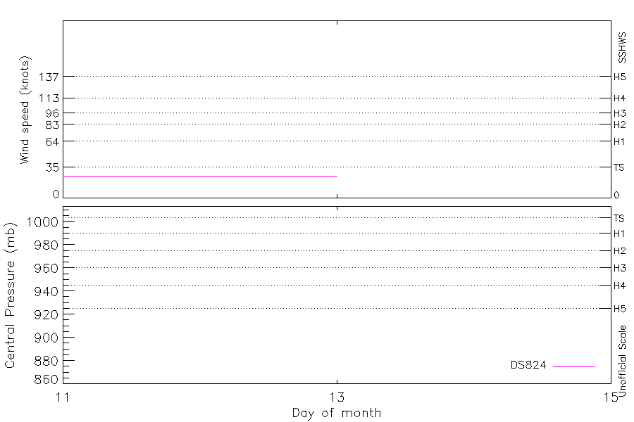
Intensity
-
Wind Radii
-
Intensity Data
-
Source Data
-
All data
Summary Information
|
|
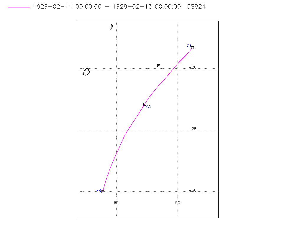
| Storm ID |
1929042S18066 |
| Start |
Feb 11 00Z |
| Max Intensity |
25 kt (Feb 11 03Z) |
| End |
Feb 13 00Z |
| ATCF IDs |
|
| Track status |
Best track data. |
|
Storm track plot
|
Intensity plots
|
Radial wind information
No radial wind information for this storm
|
Position and Intensity Table
| BASIN |
ISO_TIME_________ |
NATURE |
LAT |
LON |
DS824 WIND |
| |
|
|
degrees north |
degrees east |
kts |
| SI |
1929-02-11 00:00:00 |
TS |
-18.30 |
66.20 |
25 |
| SI |
03:00:00 |
TS |
-18.90 |
65.70 |
25 |
| SI |
06:00:00 |
TS |
-19.50 |
65.10 |
25 |
| SI |
09:00:00 |
TS |
-20.20 |
64.50 |
25 |
| SI |
12:00:00 |
TS |
-20.80 |
64.00 |
25 |
| SI |
15:00:00 |
TS |
-21.30 |
63.50 |
25 |
| SI |
18:00:00 |
TS |
-21.80 |
63.10 |
25 |
| SI |
21:00:00 |
TS |
-22.30 |
62.70 |
25 |
| SI |
1929-02-12 00:00:00 |
TS |
-22.90 |
62.30 |
25 |
| SI |
03:00:00 |
TS |
-23.70 |
61.80 |
25 |
| SI |
06:00:00 |
TS |
-24.60 |
61.20 |
25 |
| SI |
09:00:00 |
TS |
-25.40 |
60.70 |
25 |
| SI |
12:00:00 |
TS |
-26.30 |
60.30 |
25 |
| SI |
15:00:00 |
TS |
-27.20 |
59.90 |
25 |
| SI |
18:00:00 |
TS |
-28.10 |
59.50 |
25 |
| SI |
21:00:00 |
TS |
-29.00 |
59.20 |
25 |
| SI |
1929-02-13 00:00:00 |
TS |
-30.00 |
58.90 |
25 |
Source Information
| Agency |
Information |
| USA |
|
| TOKYO |
|
| CMA |
|
| HKO |
|
| KMA |
|
| NEWDELHI |
|
| REUNION |
|
| BOM |
|
| NADI |
|
| WELLINGTON |
|
| DS824 |
s_hem.dat:281:NOT NAMED |
| TD9636 |
|
| TD9635 |
|
| NEUMANN |
|
| MLC |
|
All available IBTrACS Data
| SEASON |
BASIN |
SUBBASIN |
ISO_TIME_________ |
NATURE |
LAT |
LON |
DIST2LAND |
LANDFALL |
IFLAG |
USA SSHS |
DS824 LAT |
DS824 LON |
DS824 STAGE |
DS824 WIND |
STORM SPEED |
STORM DIR |
| Year |
|
|
|
|
degrees north |
degrees east |
km |
km |
|
1 |
degrees north |
degrees east |
|
kts |
kts |
degrees |
| 1929 |
SI |
MM |
1929-02-11 00:00:00 |
TS |
-18.30 |
66.20 |
909 |
844 |
__________O____ |
-5 |
-18.30 |
66.20 |
TC |
25 |
16 |
220 |
| 1929 |
SI |
MM |
03:00:00 |
TS |
-18.90 |
65.70 |
842 |
768 |
__________P____ |
-5 |
-18.90 |
65.70 |
TC |
25 |
16 |
220 |
| 1929 |
SI |
MM |
06:00:00 |
TS |
-19.50 |
65.10 |
768 |
709 |
__________O____ |
-5 |
-19.50 |
65.10 |
TC |
25 |
17 |
220 |
| 1929 |
SI |
MM |
09:00:00 |
TS |
-20.20 |
64.50 |
698 |
647 |
__________P____ |
-5 |
-20.20 |
64.50 |
TC |
25 |
17 |
220 |
| 1929 |
SI |
MM |
12:00:00 |
TS |
-20.80 |
64.00 |
647 |
611 |
__________O____ |
-5 |
-20.80 |
64.00 |
TC |
25 |
15 |
220 |
| 1929 |
SI |
MM |
15:00:00 |
TS |
-21.30 |
63.50 |
602 |
571 |
__________P____ |
-5 |
-21.30 |
63.50 |
TC |
25 |
13 |
220 |
| 1929 |
SI |
MM |
18:00:00 |
TS |
-21.80 |
63.10 |
574 |
554 |
__________O____ |
-5 |
-21.80 |
63.10 |
TC |
25 |
12 |
220 |
| 1929 |
SI |
MM |
21:00:00 |
TS |
-22.30 |
62.70 |
554 |
544 |
__________P____ |
-5 |
-22.30 |
62.70 |
TC |
25 |
13 |
215 |
| 1929 |
SI |
MM |
1929-02-12 00:00:00 |
TS |
-22.90 |
62.30 |
545 |
539 |
__________O____ |
-5 |
-22.90 |
62.30 |
TC |
25 |
17 |
210 |
| 1929 |
SI |
MM |
03:00:00 |
TS |
-23.70 |
61.80 |
553 |
552 |
__________P____ |
-5 |
-23.70 |
61.80 |
TC |
25 |
20 |
210 |
| 1929 |
SI |
MM |
06:00:00 |
TS |
-24.60 |
61.20 |
582 |
582 |
__________O____ |
-5 |
-24.60 |
61.20 |
TC |
25 |
20 |
210 |
| 1929 |
SI |
MM |
09:00:00 |
TS |
-25.40 |
60.70 |
627 |
627 |
__________P____ |
-5 |
-25.40 |
60.70 |
TC |
25 |
19 |
205 |
| 1929 |
SI |
MM |
12:00:00 |
TS |
-26.30 |
60.30 |
700 |
700 |
__________O____ |
-5 |
-26.30 |
60.30 |
TC |
25 |
19 |
205 |
| 1929 |
SI |
MM |
15:00:00 |
TS |
-27.20 |
59.90 |
779 |
779 |
__________P____ |
-5 |
-27.20 |
59.90 |
TC |
25 |
19 |
200 |
| 1929 |
SI |
MM |
18:00:00 |
TS |
-28.10 |
59.50 |
845 |
845 |
__________O____ |
-5 |
-28.10 |
59.50 |
TC |
25 |
20 |
200 |
| 1929 |
SI |
MM |
21:00:00 |
TS |
-29.00 |
59.20 |
922 |
922 |
__________P____ |
-5 |
-29.00 |
59.20 |
TC |
25 |
20 |
195 |
| 1929 |
SI |
MM |
1929-02-13 00:00:00 |
TS |
-30.00 |
58.90 |
1015 |
|
__________O____ |
-5 |
-30.00 |
58.90 |
TC |
25 |
20 |
195 |