1945
Tropical Storm PEGGY (1945204N17118)
IBTrACS version v04r01. Visit
IBTrACS website for data access.
Please direct all questions to the
IBTrACS Q and A forum
Storm track
-
Intensity
-
Wind Radii
-
Intensity Data
-
Source Data
-
All data
Summary Information
|
|
| Storm ID |
1945204N17118 |
| Start |
Jul 22 12Z |
| Max Intensity |
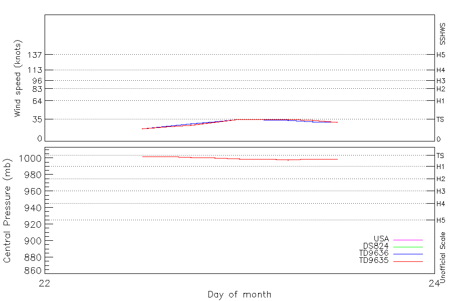
35 kt (Jul 23 00Z), 998 mb (Jul 23 06Z) |
| End |
Jul 23 12Z |
| ATCF IDs |
WP071945 |
| Track status |
Best track data. |
|
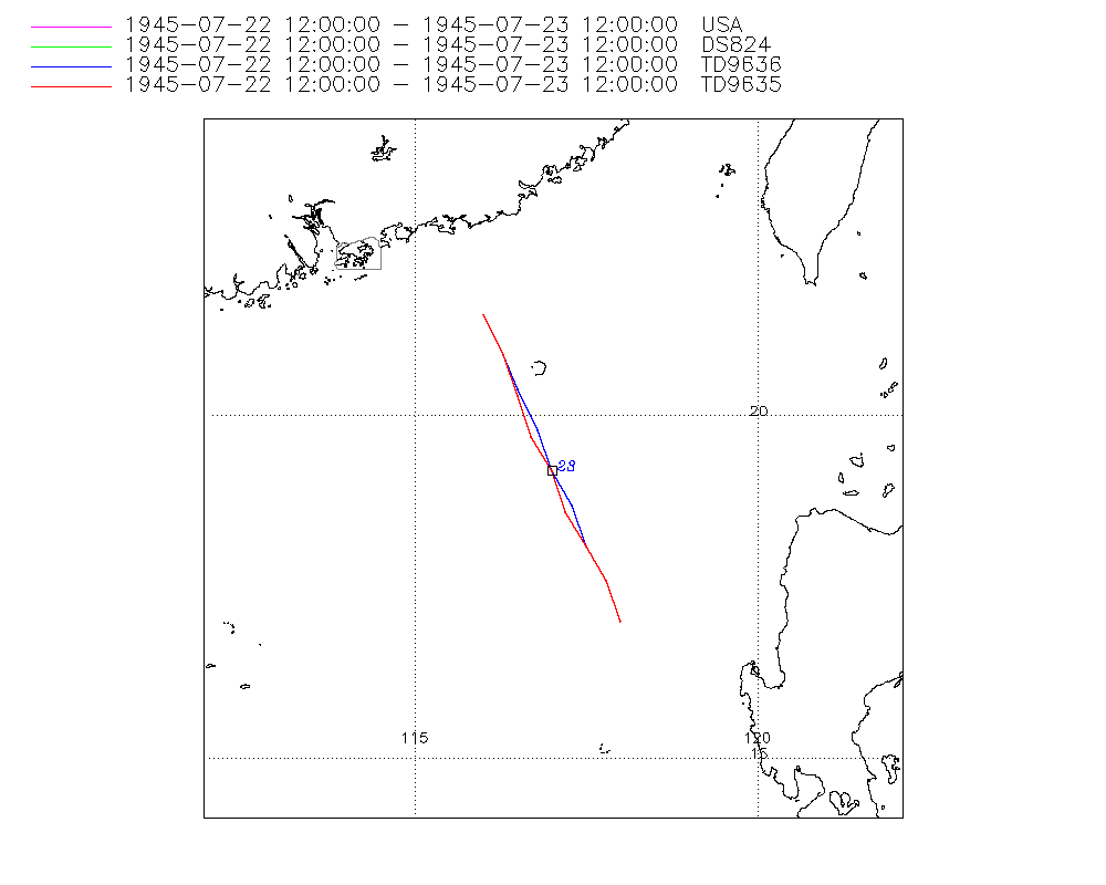
Storm track plot
|
Intensity plots
|
Radial wind information
|
Position and Intensity Table
| BASIN |
ISO_TIME_________ |
NATURE |
LAT |
LON |
USA WIND |
DS824 WIND |
TD9636 WIND |
TD9635 WIND |
TD9635 PRES |
| |
|
|
degrees north |
degrees east |
kts |
kts |
kts |
kts |
mb |
| WP |
1945-07-22 12:00:00 |
TS |
17.00 |
118.00 |
20 |
20 |
20 |
20 |
1002 |
| WP |
15:00:00 |
TS |
17.60 |
117.80 |
23 |
23 |
24 |
23 |
1002 |
| WP |
18:00:00 |
TS |
18.10 |
117.50 |
25 |
25 |
28 |
25 |
1001 |
| WP |
21:00:00 |
TS |
18.70 |
117.30 |
30 |
30 |
31 |
30 |
1000 |
| WP |
1945-07-23 00:00:00 |
TS |
19.20 |
117.00 |
35 |
35 |
35 |
35 |
999 |
| WP |
03:00:00 |
TS |
19.80 |
116.80 |
35 |
35 |
34 |
35 |
999 |
| WP |
06:00:00 |
TS |
20.30 |
116.50 |
35 |
35 |
33 |
35 |
998 |
| WP |
09:00:00 |
TS |
20.90 |
116.30 |
33 |
33 |
31 |
33 |
999 |
| WP |
12:00:00 |
TS |
21.50 |
116.00 |
30 |
30 |
30 |
30 |
999 |
Source Information
| Agency |
Information |
| USA |
bwp071945.txt |
| TOKYO |
|
| CMA |
|
| HKO |
|
| KMA |
|
| NEWDELHI |
|
| REUNION |
|
| BOM |
|
| NADI |
|
| WELLINGTON |
|
| DS824 |
w_npac.dat:7:07W |
| TD9636 |
cons_worldwide_trop_cyclone_18710101-19891231-003:Line=13787 |
| TD9635 |
typhoons-analogs_19450101-19761231.corrected:Line=2748 |
| NEUMANN |
|
| MLC |
|
All available IBTrACS Data
| SEASON |
BASIN |
SUBBASIN |
ISO_TIME_________ |
NATURE |
LAT |
LON |
DIST2LAND |
LANDFALL |
IFLAG |
USA AGENCY |
USA ATCF_ID |
USA LAT |
USA LON |
USA WIND |
USA SSHS |
DS824 LAT |
DS824 LON |
DS824 STAGE |
DS824 WIND |
TD9636 LAT |
TD9636 LON |
TD9636 STAGE |
TD9636 WIND |
TD9635 LAT |
TD9635 LON |
TD9635 WIND |
TD9635 PRES |
TD9635 ROCI |
STORM SPEED |
STORM DIR |
| Year |
|
|
|
|
degrees north |
degrees east |
km |
km |
|
|
|
degrees north |
degrees east |
kts |
1 |
degrees north |
degrees east |
|
kts |
degrees north |
degrees east |
|
kts |
degrees north |
degrees east |
kts |
mb |
nmile |
kts |
degrees |
| 1945 |
WP |
MM |
1945-07-22 12:00:00 |
TS |
17.00 |
118.00 |
207 |
207 |
O_________OOO__ |
jtwc_wp |
WP071945 |
17.00 |
118.00 |
20 |
-1 |
17.00 |
118.00 |
TC |
20 |
17.00 |
118.00 |
1 |
20 |
17.00 |
118.00 |
20 |
1002 |
120 |
12 |
335 |
| 1945 |
WP |
MM |
15:00:00 |
TS |
17.60 |
117.80 |
257 |
257 |
P_________PPP__ |
|
WP071945 |
17.60 |
117.80 |
23 |
-1 |
17.60 |
117.80 |
TC |
23 |
17.60 |
117.80 |
1 |
24 |
17.60 |
117.80 |
23 |
1002 |
120 |
12 |
335 |
| 1945 |
WP |
MM |
18:00:00 |
TS |
18.10 |
117.50 |
301 |
301 |
O_________OPO__ |
jtwc_wp |
WP071945 |
18.10 |
117.50 |
25 |
-1 |
18.10 |
117.50 |
TC |
25 |
18.10 |
117.50 |
1 |
28 |
18.10 |
117.50 |
25 |
1001 |
120 |
12 |
335 |
| 1945 |
WP |
MM |
21:00:00 |
TS |
18.70 |
117.30 |
340 |
340 |
P_________PPP__ |
|
WP071945 |
18.60 |
117.20 |
30 |
-1 |
18.60 |
117.20 |
TC |
30 |
18.70 |
117.30 |
1 |
31 |
18.60 |
117.20 |
30 |
1000 |
120 |
12 |
335 |
| 1945 |
WP |
MM |
1945-07-23 00:00:00 |
TS |
19.20 |
117.00 |
388 |
351 |
O_________OOO__ |
jtwc_wp |
WP071945 |
19.20 |
117.00 |
35 |
0 |
19.20 |
117.00 |
TC |
35 |
19.20 |
117.00 |
2 |
35 |
19.20 |
117.00 |
35 |
999 |
120 |
12 |
335 |
| 1945 |
WP |
MM |
03:00:00 |
TS |
19.80 |
116.80 |
340 |
277 |
P_________PPP__ |
|
WP071945 |
19.70 |
116.70 |
35 |
0 |
19.70 |
116.70 |
TC |
35 |
19.80 |
116.80 |
2 |
34 |
19.70 |
116.70 |
35 |
999 |
120 |
12 |
335 |
| 1945 |
WP |
MM |
06:00:00 |
TS |
20.30 |
116.50 |
277 |
207 |
O_________OPO__ |
jtwc_wp |
WP071945 |
20.30 |
116.50 |
35 |
0 |
20.30 |
116.50 |
TC |
35 |
20.40 |
116.50 |
2 |
33 |
20.30 |
116.50 |
35 |
998 |
120 |
12 |
340 |
| 1945 |
WP |
MM |
09:00:00 |
TS |
20.90 |
116.30 |
207 |
135 |
P_________PPP__ |
|
WP071945 |
20.90 |
116.30 |
33 |
-1 |
20.90 |
116.30 |
TC |
33 |
20.90 |
116.30 |
2 |
31 |
20.90 |
116.30 |
33 |
999 |
120 |
13 |
340 |
| 1945 |
WP |
MM |
12:00:00 |
TS |
21.50 |
116.00 |
135 |
|
O_________OOO__ |
jtwc_wp |
WP071945 |
21.50 |
116.00 |
30 |
-1 |
21.50 |
116.00 |
TC |
30 |
21.50 |
116.00 |
1 |
30 |
21.50 |
116.00 |
30 |
999 |
120 |
13 |
340 |