1948
Tropical Depression UNNAMED (1948044S21041)
IBTrACS version v04r01. Visit
IBTrACS website for data access.
Please direct all questions to the
IBTrACS Q and A forum
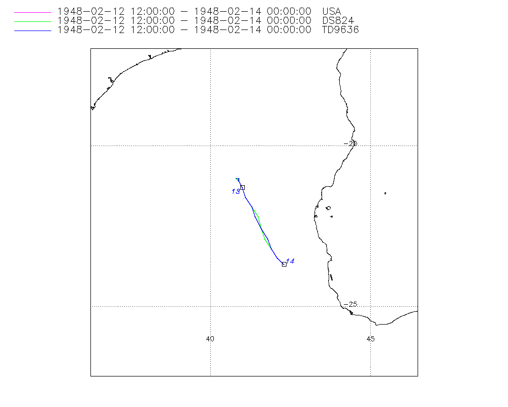
Storm track
-
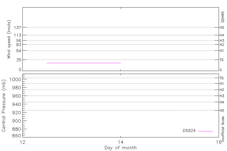
Intensity
-
Wind Radii
-
Intensity Data
-
Source Data
-
All data
Summary Information
|
|
| Storm ID |
1948044S21041 |
| Start |
Feb 12 12Z |
| Max Intensity |
25 kt (Feb 12 15Z) |
| End |
Feb 14 00Z |
| ATCF IDs |
SH131948 |
| Track status |
Best track data. |
|
Storm track plot
|
Intensity plots
|
Radial wind information
No radial wind information for this storm
|
Position and Intensity Table
| BASIN |
ISO_TIME_________ |
NATURE |
LAT |
LON |
DS824 WIND |
| |
|
|
degrees north |
degrees east |
kts |
| SI |
1948-02-12 12:00:00 |
TS |
-21.00 |
40.80 |
25 |
| SI |
15:00:00 |
TS |
-21.00 |
40.80 |
25 |
| SI |
18:00:00 |
TS |
-21.00 |
40.80 |
25 |
| SI |
21:00:00 |
TS |
-21.10 |
40.90 |
25 |
| SI |
1948-02-13 00:00:00 |
TS |
-21.30 |
41.00 |
25 |
| SI |
03:00:00 |
TS |
-21.60 |
41.10 |
25 |
| SI |
06:00:00 |
TS |
-21.90 |
41.30 |
25 |
| SI |
09:00:00 |
TS |
-22.20 |
41.40 |
25 |
| SI |
12:00:00 |
TS |
-22.60 |
41.60 |
25 |
| SI |
15:00:00 |
TS |
-22.90 |
41.80 |
25 |
| SI |
18:00:00 |
TS |
-23.20 |
41.90 |
25 |
| SI |
21:00:00 |
TS |
-23.50 |
42.10 |
25 |
| SI |
1948-02-14 00:00:00 |
TS |
-23.70 |
42.30 |
25 |
Source Information
| Agency |
Information |
| USA |
bsh131948.txt |
| TOKYO |
|
| CMA |
|
| HKO |
|
| KMA |
|
| NEWDELHI |
|
| REUNION |
|
| BOM |
|
| NADI |
|
| WELLINGTON |
|
| DS824 |
s_hem.dat:486:13S |
| TD9636 |
cons_worldwide_trop_cyclone_18710101-19891231-005:Line=6154 |
| TD9635 |
|
| NEUMANN |
|
| MLC |
|
All available IBTrACS Data
| SEASON |
BASIN |
SUBBASIN |
ISO_TIME_________ |
NATURE |
LAT |
LON |
DIST2LAND |
LANDFALL |
IFLAG |
USA AGENCY |
USA ATCF_ID |
USA LAT |
USA LON |
USA SSHS |
DS824 LAT |
DS824 LON |
DS824 STAGE |
DS824 WIND |
TD9636 LAT |
TD9636 LON |
TD9636 STAGE |
STORM SPEED |
STORM DIR |
| Year |
|
|
|
|
degrees north |
degrees east |
km |
km |
|
|
|
degrees north |
degrees east |
1 |
degrees north |
degrees east |
|
kts |
degrees north |
degrees east |
|
kts |
degrees |
| 1948 |
SI |
MM |
1948-02-12 12:00:00 |
TS |
-21.00 |
40.80 |
281 |
281 |
O_________OO___ |
jtwc_sh |
SH131948 |
-21.00 |
40.80 |
-5 |
-21.00 |
40.80 |
TC |
25 |
-21.00 |
40.80 |
7 |
0 |
0 |
| 1948 |
SI |
MM |
15:00:00 |
TS |
-21.00 |
40.80 |
281 |
281 |
P_________PP___ |
|
SH131948 |
-21.00 |
40.80 |
-5 |
-21.00 |
40.80 |
TC |
25 |
-21.00 |
40.80 |
7 |
0 |
0 |
| 1948 |
SI |
MM |
18:00:00 |
TS |
-21.00 |
40.80 |
281 |
267 |
O_________OP___ |
jtwc_sh |
SH131948 |
-21.00 |
40.80 |
-5 |
-21.00 |
40.80 |
TC |
25 |
-21.00 |
40.90 |
7 |
2 |
145 |
| 1948 |
SI |
MM |
21:00:00 |
TS |
-21.10 |
40.90 |
267 |
248 |
P_________PP___ |
|
SH131948 |
-21.10 |
40.90 |
-5 |
-21.10 |
40.90 |
TC |
25 |
-21.10 |
40.90 |
7 |
3 |
150 |
| 1948 |
SI |
MM |
1948-02-13 00:00:00 |
TS |
-21.30 |
41.00 |
248 |
226 |
O_________OO___ |
jtwc_sh |
SH131948 |
-21.30 |
41.00 |
-5 |
-21.30 |
41.00 |
TC |
25 |
-21.30 |
41.00 |
7 |
5 |
155 |
| 1948 |
SI |
MM |
03:00:00 |
TS |
-21.60 |
41.10 |
226 |
198 |
P_________PP___ |
|
SH131948 |
-21.60 |
41.10 |
-5 |
-21.60 |
41.10 |
TC |
25 |
-21.60 |
41.10 |
7 |
7 |
155 |
| 1948 |
SI |
MM |
06:00:00 |
TS |
-21.90 |
41.30 |
198 |
185 |
O_________OP___ |
jtwc_sh |
SH131948 |
-21.90 |
41.30 |
-5 |
-21.90 |
41.30 |
TC |
25 |
-21.90 |
41.30 |
7 |
7 |
155 |
| 1948 |
SI |
MM |
09:00:00 |
TS |
-22.20 |
41.40 |
185 |
165 |
P_________PP___ |
|
SH131948 |
-22.20 |
41.50 |
-5 |
-22.20 |
41.50 |
TC |
25 |
-22.20 |
41.40 |
7 |
8 |
160 |
| 1948 |
SI |
MM |
12:00:00 |
TS |
-22.60 |
41.60 |
167 |
160 |
O_________OO___ |
jtwc_sh |
SH131948 |
-22.60 |
41.60 |
-5 |
-22.60 |
41.60 |
TC |
25 |
-22.60 |
41.60 |
7 |
7 |
155 |
| 1948 |
SI |
MM |
15:00:00 |
TS |
-22.90 |
41.80 |
158 |
157 |
P_________PP___ |
|
SH131948 |
-22.90 |
41.70 |
-5 |
-22.90 |
41.70 |
TC |
25 |
-22.90 |
41.80 |
7 |
7 |
155 |
| 1948 |
SI |
MM |
18:00:00 |
TS |
-23.20 |
41.90 |
159 |
148 |
O_________OP___ |
jtwc_sh |
SH131948 |
-23.20 |
41.90 |
-5 |
-23.20 |
41.90 |
TC |
25 |
-23.20 |
41.90 |
7 |
6 |
150 |
| 1948 |
SI |
MM |
21:00:00 |
TS |
-23.50 |
42.10 |
154 |
132 |
P_________PP___ |
|
SH131948 |
-23.50 |
42.10 |
-5 |
-23.50 |
42.10 |
TC |
25 |
-23.50 |
42.10 |
7 |
6 |
145 |
| 1948 |
SI |
MM |
1948-02-14 00:00:00 |
TS |
-23.70 |
42.30 |
132 |
|
O_________OO___ |
jtwc_sh |
SH131948 |
-23.70 |
42.30 |
-5 |
-23.70 |
42.30 |
TC |
25 |
-23.70 |
42.30 |
7 |
6 |
145 |