1948
Tropical Storm OPHELIA (1948160N23121)
IBTrACS version v04r01. Visit
IBTrACS website for data access.
Please direct all questions to the
IBTrACS Q and A forum
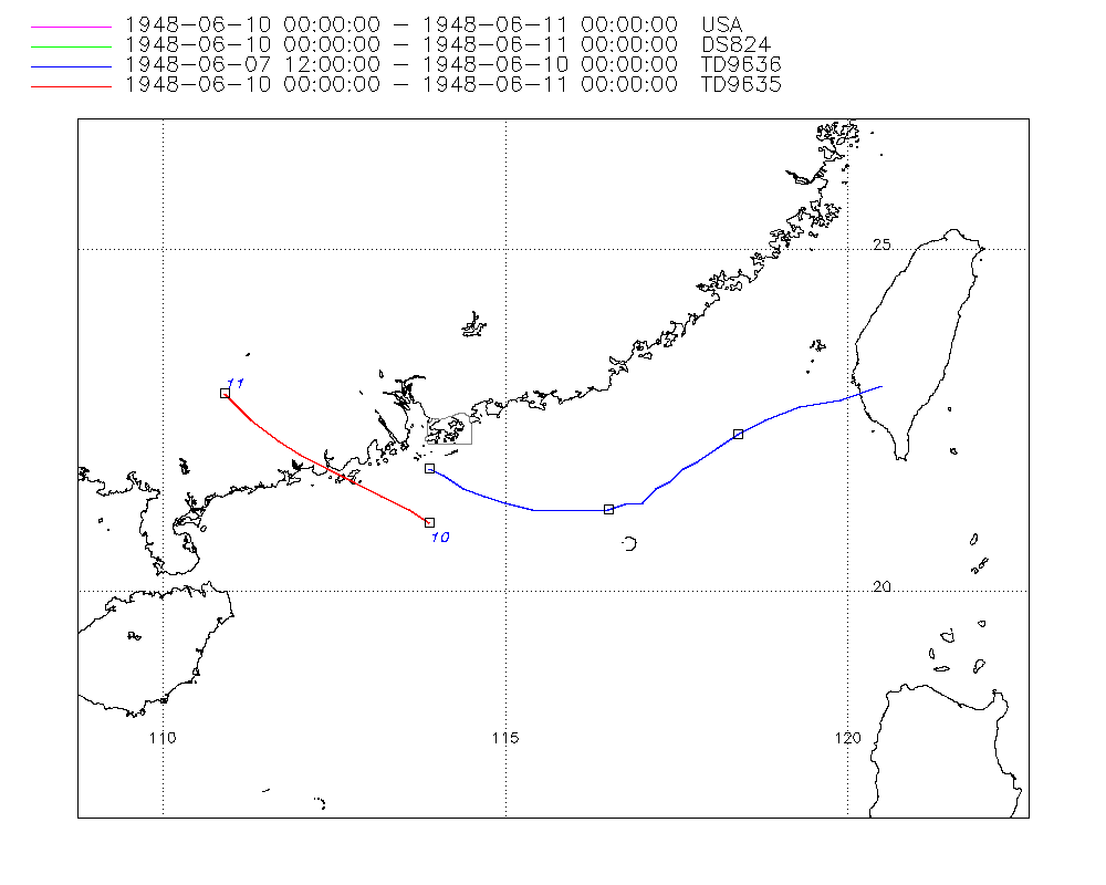
Storm track
-
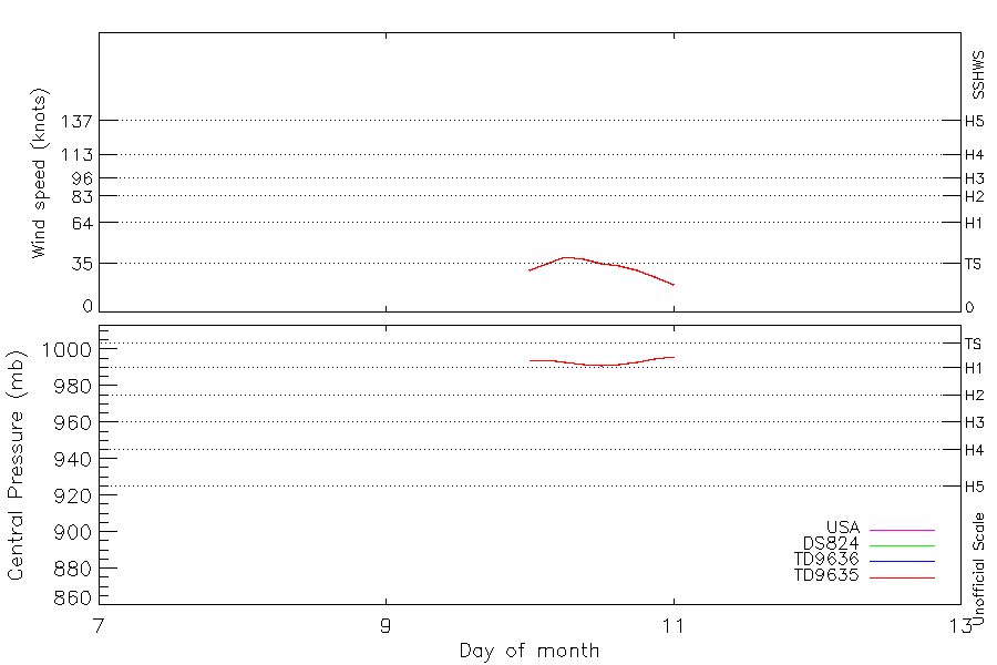
Intensity
-
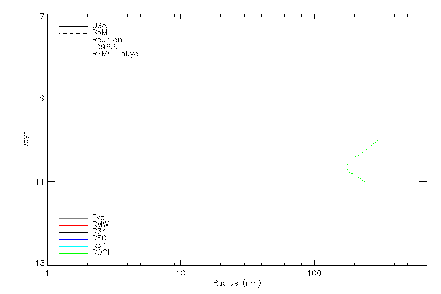
Wind Radii
-
Intensity Data
-
Source Data
-
All data
Summary Information
|
|
| Storm ID |
1948160N23121 |
| Start |
Jun 7 12Z |
| Landfall |
Jun 10 12Z |
| Max Intensity |
40 kt (Jun 10 06Z), 991 mb (Jun 10 12Z) |
| End |
Jun 11 00Z |
| ATCF IDs |
,WP051948 |
| Track status |
Best track data. |
|
Storm track plot
|
Intensity plots
|
Radial wind information
|
Position and Intensity Table
| BASIN |
ISO_TIME_________ |
NATURE |
LAT |
LON |
USA WIND |
DS824 WIND |
TD9636 WIND |
TD9635 WIND |
TD9635 PRES |
| |
|
|
degrees north |
degrees east |
kts |
kts |
kts |
kts |
mb |
| WP |
1948-06-07 12:00:00 |
TS |
23.00 |
120.50 |
|
|
|
|
|
| WP |
15:00:00 |
TS |
22.80 |
119.90 |
|
|
|
|
|
| WP |
18:00:00 |
TS |
22.70 |
119.30 |
|
|
|
|
|
| WP |
21:00:00 |
TS |
22.50 |
118.80 |
|
|
|
|
|
| WP |
1948-06-08 00:00:00 |
TS |
22.30 |
118.40 |
|
|
|
|
|
| WP |
03:00:00 |
TS |
22.10 |
118.10 |
|
|
|
|
|
| WP |
06:00:00 |
TS |
21.90 |
117.80 |
|
|
|
|
|
| WP |
09:00:00 |
TS |
21.80 |
117.60 |
|
|
|
|
|
| WP |
12:00:00 |
TS |
21.60 |
117.40 |
|
|
|
|
|
| WP |
15:00:00 |
TS |
21.50 |
117.20 |
|
|
|
|
|
| WP |
18:00:00 |
TS |
21.30 |
117.00 |
|
|
|
|
|
| WP |
21:00:00 |
TS |
21.30 |
116.80 |
|
|
|
|
|
| WP |
1948-06-09 00:00:00 |
TS |
21.20 |
116.50 |
|
|
|
|
|
| WP |
03:00:00 |
TS |
21.20 |
116.20 |
|
|
|
|
|
| WP |
06:00:00 |
TS |
21.20 |
115.80 |
|
|
|
|
|
| WP |
09:00:00 |
TS |
21.20 |
115.40 |
|
|
|
|
|
| WP |
12:00:00 |
TS |
21.30 |
115.00 |
|
|
|
|
|
| WP |
15:00:00 |
TS |
21.40 |
114.70 |
|
|
|
|
|
| WP |
18:00:00 |
TS |
21.50 |
114.40 |
|
|
|
|
|
| WP |
21:00:00 |
TS |
21.70 |
114.10 |
|
|
|
|
|
| WP |
1948-06-10 00:00:00 |
TS |
21.00 |
113.90 |
30 |
30 |
30 |
30 |
994 |
| WP |
03:00:00 |
TS |
21.20 |
113.60 |
35 |
35 |
|
35 |
994 |
| WP |
06:00:00 |
TS |
21.40 |
113.20 |
40 |
40 |
|
40 |
993 |
| WP |
09:00:00 |
TS |
21.60 |
112.80 |
38 |
38 |
|
38 |
992 |
| WP |
12:00:00 |
TS |
21.80 |
112.40 |
35 |
35 |
|
35 |
991 |
| WP |
15:00:00 |
TS |
22.00 |
112.00 |
33 |
33 |
|
33 |
992 |
| WP |
18:00:00 |
TS |
22.20 |
111.70 |
30 |
30 |
|
30 |
993 |
| WP |
21:00:00 |
TS |
22.50 |
111.30 |
25 |
25 |
|
25 |
995 |
| WP |
1948-06-11 00:00:00 |
TS |
22.90 |
110.90 |
20 |
20 |
|
20 |
996 |
Source Information
| Agency |
Information |
| USA |
bwp051948.txt |
| TOKYO |
|
| CMA |
|
| HKO |
|
| KMA |
|
| NEWDELHI |
|
| REUNION |
|
| BOM |
|
| NADI |
|
| WELLINGTON |
|
| DS824 |
w_npac.dat:73:05W |
| TD9636 |
cons_worldwide_trop_cyclone_18710101-19891231-003:Line=14678 |
| TD9635 |
typhoons-analogs_19450101-19761231.corrected:Line=1956 |
| NEUMANN |
|
| MLC |
|
All available IBTrACS Data
| SEASON |
BASIN |
SUBBASIN |
ISO_TIME_________ |
NATURE |
LAT |
LON |
DIST2LAND |
LANDFALL |
IFLAG |
USA AGENCY |
USA ATCF_ID |
USA LAT |
USA LON |
USA WIND |
USA SSHS |
DS824 LAT |
DS824 LON |
DS824 STAGE |
DS824 WIND |
TD9636 LAT |
TD9636 LON |
TD9636 STAGE |
TD9636 WIND |
TD9635 LAT |
TD9635 LON |
TD9635 WIND |
TD9635 PRES |
TD9635 ROCI |
STORM SPEED |
STORM DIR |
| Year |
|
|
|
|
degrees north |
degrees east |
km |
km |
|
|
|
degrees north |
degrees east |
kts |
1 |
degrees north |
degrees east |
|
kts |
degrees north |
degrees east |
|
kts |
degrees north |
degrees east |
kts |
mb |
nmile |
kts |
degrees |
| 1948 |
WP |
MM |
1948-06-07 12:00:00 |
TS |
23.00 |
120.50 |
0 |
0 |
___________O___ |
|
|
|
|
|
-5 |
|
|
|
|
23.00 |
120.50 |
2 |
|
|
|
|
|
|
11 |
255 |
| 1948 |
WP |
MM |
15:00:00 |
TS |
22.80 |
119.90 |
30 |
30 |
___________P___ |
|
|
|
|
|
-5 |
|
|
|
|
22.80 |
119.90 |
2 |
|
|
|
|
|
|
11 |
250 |
| 1948 |
WP |
MM |
18:00:00 |
TS |
22.70 |
119.30 |
92 |
92 |
___________P___ |
|
|
|
|
|
-5 |
|
|
|
|
22.70 |
119.30 |
2 |
|
|
|
|
|
|
11 |
250 |
| 1948 |
WP |
MM |
21:00:00 |
TS |
22.50 |
118.80 |
147 |
147 |
___________P___ |
|
|
|
|
|
-5 |
|
|
|
|
22.50 |
118.80 |
2 |
|
|
|
|
|
|
9 |
250 |
| 1948 |
WP |
MM |
1948-06-08 00:00:00 |
TS |
22.30 |
118.40 |
176 |
172 |
___________O___ |
|
|
|
|
|
-5 |
|
|
|
|
22.30 |
118.40 |
2 |
|
|
|
|
|
|
8 |
240 |
| 1948 |
WP |
MM |
03:00:00 |
TS |
22.10 |
118.10 |
186 |
167 |
___________P___ |
|
|
|
|
|
-5 |
|
|
|
|
22.10 |
118.10 |
2 |
|
|
|
|
|
|
7 |
235 |
| 1948 |
WP |
MM |
06:00:00 |
TS |
21.90 |
117.80 |
174 |
166 |
___________P___ |
|
|
|
|
|
-5 |
|
|
|
|
21.90 |
117.80 |
2 |
|
|
|
|
|
|
6 |
230 |
| 1948 |
WP |
MM |
09:00:00 |
TS |
21.80 |
117.60 |
167 |
167 |
___________P___ |
|
|
|
|
|
-5 |
|
|
|
|
21.80 |
117.60 |
2 |
|
|
|
|
|
|
5 |
230 |
| 1948 |
WP |
MM |
12:00:00 |
TS |
21.60 |
117.40 |
172 |
167 |
___________O___ |
|
|
|
|
|
-5 |
|
|
|
|
21.60 |
117.40 |
2 |
|
|
|
|
|
|
5 |
230 |
| 1948 |
WP |
MM |
15:00:00 |
TS |
21.50 |
117.20 |
172 |
172 |
___________P___ |
|
|
|
|
|
-5 |
|
|
|
|
21.50 |
117.20 |
2 |
|
|
|
|
|
|
5 |
235 |
| 1948 |
WP |
MM |
18:00:00 |
TS |
21.30 |
117.00 |
186 |
181 |
___________P___ |
|
|
|
|
|
-5 |
|
|
|
|
21.30 |
117.00 |
2 |
|
|
|
|
|
|
4 |
245 |
| 1948 |
WP |
MM |
21:00:00 |
TS |
21.30 |
116.80 |
181 |
181 |
___________P___ |
|
|
|
|
|
-5 |
|
|
|
|
21.30 |
116.80 |
2 |
|
|
|
|
|
|
5 |
255 |
| 1948 |
WP |
MM |
1948-06-09 00:00:00 |
TS |
21.20 |
116.50 |
182 |
172 |
___________O___ |
|
|
|
|
|
-5 |
|
|
|
|
21.20 |
116.50 |
2 |
|
|
|
|
|
|
6 |
260 |
| 1948 |
WP |
MM |
03:00:00 |
TS |
21.20 |
116.20 |
172 |
167 |
___________P___ |
|
|
|
|
|
-5 |
|
|
|
|
21.20 |
116.20 |
2 |
|
|
|
|
|
|
7 |
270 |
| 1948 |
WP |
MM |
06:00:00 |
TS |
21.20 |
115.80 |
167 |
154 |
___________P___ |
|
|
|
|
|
-5 |
|
|
|
|
21.20 |
115.80 |
2 |
|
|
|
|
|
|
7 |
275 |
| 1948 |
WP |
MM |
09:00:00 |
TS |
21.20 |
115.40 |
154 |
133 |
___________P___ |
|
|
|
|
|
-5 |
|
|
|
|
21.20 |
115.40 |
2 |
|
|
|
|
|
|
7 |
280 |
| 1948 |
WP |
MM |
12:00:00 |
TS |
21.30 |
115.00 |
133 |
108 |
___________O___ |
|
|
|
|
|
-5 |
|
|
|
|
21.30 |
115.00 |
2 |
|
|
|
|
|
|
7 |
285 |
| 1948 |
WP |
MM |
15:00:00 |
TS |
21.40 |
114.70 |
108 |
90 |
___________P___ |
|
|
|
|
|
-5 |
|
|
|
|
21.40 |
114.70 |
2 |
|
|
|
|
|
|
6 |
290 |
| 1948 |
WP |
MM |
18:00:00 |
TS |
21.50 |
114.40 |
90 |
67 |
___________P___ |
|
|
|
|
|
-5 |
|
|
|
|
21.50 |
114.40 |
2 |
|
|
|
|
|
|
6 |
295 |
| 1948 |
WP |
MM |
21:00:00 |
TS |
21.70 |
114.10 |
70 |
70 |
___________P___ |
|
|
|
|
|
-5 |
|
|
|
|
21.70 |
114.10 |
2 |
|
|
|
|
|
|
7 |
220 |
| 1948 |
WP |
MM |
1948-06-10 00:00:00 |
TS |
21.00 |
113.90 |
137 |
99 |
O_________OOO__ |
jtwc_wp |
WP051948 |
21.00 |
113.90 |
30 |
-1 |
21.00 |
113.90 |
TC |
30 |
21.80 |
113.90 |
1 |
30 |
21.00 |
113.90 |
30 |
994 |
300 |
7 |
230 |
| 1948 |
WP |
MM |
03:00:00 |
TS |
21.20 |
113.60 |
99 |
59 |
P_________P_P__ |
|
WP051948 |
21.20 |
113.60 |
35 |
0 |
21.20 |
113.60 |
TC |
35 |
|
|
|
|
21.20 |
113.60 |
35 |
994 |
270 |
8 |
300 |
| 1948 |
WP |
MM |
06:00:00 |
TS |
21.40 |
113.20 |
59 |
30 |
O_________O_O__ |
jtwc_wp |
WP051948 |
21.40 |
113.20 |
40 |
0 |
21.40 |
113.20 |
TC |
40 |
|
|
|
|
21.40 |
113.20 |
40 |
993 |
240 |
8 |
300 |
| 1948 |
WP |
MM |
09:00:00 |
TS |
21.60 |
112.80 |
30 |
0 |
P_________P_P__ |
|
WP051948 |
21.60 |
112.80 |
38 |
0 |
21.60 |
112.80 |
TC |
38 |
|
|
|
|
21.60 |
112.80 |
38 |
992 |
210 |
8 |
300 |
| 1948 |
WP |
MM |
12:00:00 |
TS |
21.80 |
112.40 |
0 |
0 |
O_________O_O__ |
jtwc_wp |
WP051948 |
21.80 |
112.40 |
35 |
0 |
21.80 |
112.40 |
TC |
35 |
|
|
|
|
21.80 |
112.40 |
35 |
991 |
180 |
8 |
300 |
| 1948 |
WP |
MM |
15:00:00 |
TS |
22.00 |
112.00 |
0 |
0 |
P_________P_P__ |
|
WP051948 |
22.00 |
112.00 |
33 |
-1 |
22.00 |
112.00 |
TC |
33 |
|
|
|
|
22.00 |
112.00 |
33 |
992 |
180 |
8 |
300 |
| 1948 |
WP |
MM |
18:00:00 |
TS |
22.20 |
111.70 |
0 |
0 |
O_________O_O__ |
jtwc_wp |
WP051948 |
22.20 |
111.70 |
30 |
-1 |
22.20 |
111.70 |
TC |
30 |
|
|
|
|
22.20 |
111.70 |
30 |
993 |
180 |
9 |
310 |
| 1948 |
WP |
MM |
21:00:00 |
TS |
22.50 |
111.30 |
0 |
0 |
P_________P_P__ |
|
WP051948 |
22.50 |
111.30 |
25 |
-1 |
22.50 |
111.30 |
TC |
25 |
|
|
|
|
22.50 |
111.30 |
25 |
995 |
210 |
10 |
315 |
| 1948 |
WP |
MM |
1948-06-11 00:00:00 |
TS |
22.90 |
110.90 |
0 |
|
O_________O_O__ |
jtwc_wp |
WP051948 |
22.90 |
110.90 |
20 |
-1 |
22.90 |
110.90 |
TC |
20 |
|
|
|
|
22.90 |
110.90 |
20 |
996 |
240 |
11 |
315 |