1949
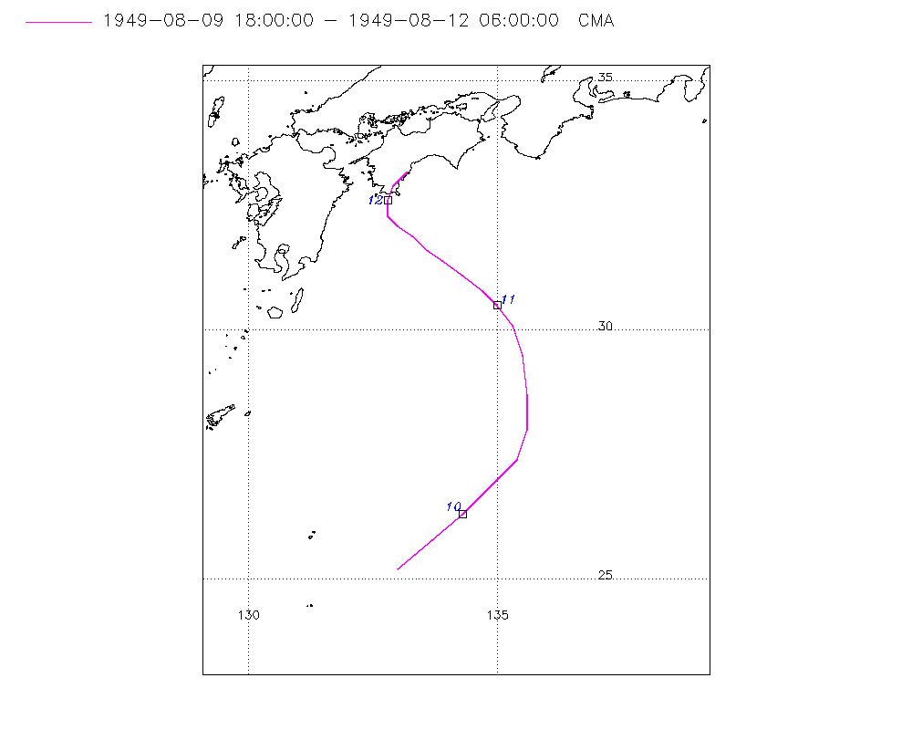
Tropical Depression UNNAMED (1949222N25133)
IBTrACS version v04r01. Visit
IBTrACS website for data access.
Please direct all questions to the
IBTrACS Q and A forum
Storm track
-
Intensity
-
Wind Radii
-
Intensity Data
-
Source Data
-
All data
Summary Information
|
|
| Storm ID |
1949222N25133 |
| Start |
Aug 9 18Z |
| Landfall |
Aug 12 03Z |
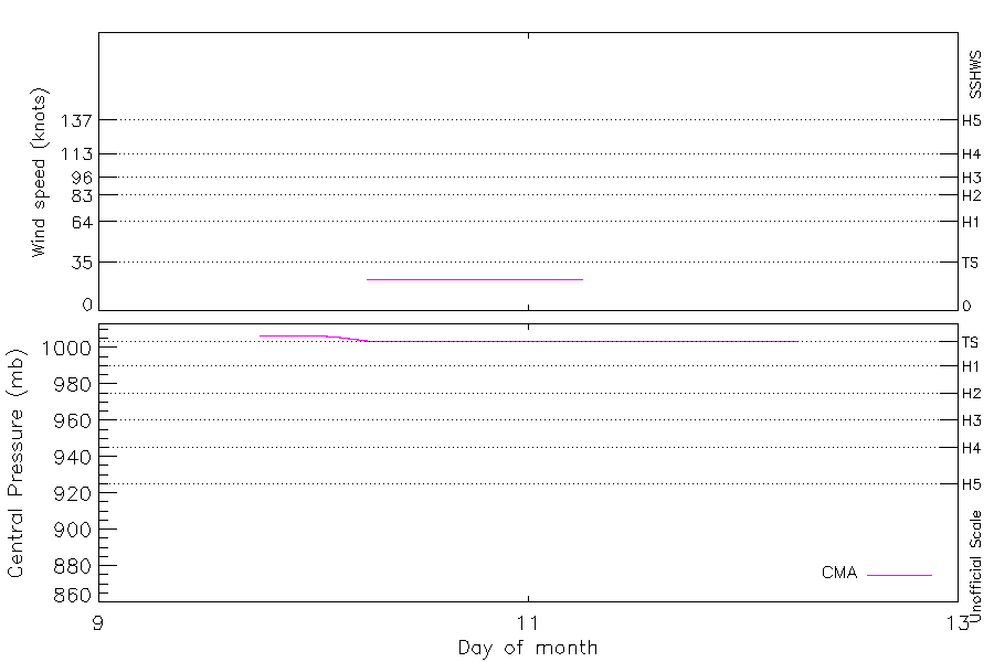
| Max Intensity |
23 kt (Aug 10 06Z) |
| End |
Aug 12 06Z |
| ATCF IDs |
|
| Track status |
Best track data. |
|
Storm track plot
|
Intensity plots
|
Radial wind information
No radial wind information for this storm
|
Position and Intensity Table
| BASIN |
ISO_TIME_________ |
NATURE |
LAT |
LON |
CMA WIND |
CMA PRES |
| |
|
|
degrees north |
degrees east |
kts |
mb |
| WP |
1949-08-09 18:00:00 |
DS |
25.20 |
133.00 |
|
1007 |
| WP |
21:00:00 |
DS |
25.80 |
133.70 |
|
1007 |
| WP |
1949-08-10 00:00:00 |
DS |
26.30 |
134.30 |
|
1007 |
| WP |
03:00:00 |
DS |
26.70 |
134.70 |
|
1006 |
| WP |
06:00:00 |
TS |
27.00 |
135.00 |
23 |
1004 |
| WP |
09:00:00 |
TS |
27.40 |
135.40 |
23 |
1004 |
| WP |
12:00:00 |
TS |
28.00 |
135.60 |
23 |
1004 |
| WP |
15:00:00 |
TS |
28.70 |
135.60 |
23 |
1004 |
| WP |
18:00:00 |
TS |
29.50 |
135.50 |
23 |
1004 |
| WP |
21:00:00 |
TS |
30.10 |
135.30 |
23 |
1004 |
| WP |
1949-08-11 00:00:00 |
TS |
30.50 |
135.00 |
23 |
1004 |
| WP |
03:00:00 |
TS |
30.80 |
134.70 |
23 |
1004 |
| WP |
06:00:00 |
TS |
31.10 |
134.30 |
23 |
1004 |
| WP |
09:00:00 |
TS |
31.40 |
133.90 |
|
1004 |
| WP |
12:00:00 |
DS |
31.60 |
133.60 |
|
1004 |
| WP |
15:00:00 |
DS |
31.90 |
133.30 |
|
1004 |
| WP |
18:00:00 |
DS |
32.10 |
133.00 |
|
1004 |
| WP |
21:00:00 |
DS |
32.30 |
132.80 |
|
1004 |
| WP |
1949-08-12 00:00:00 |
DS |
32.60 |
132.80 |
|
1004 |
| WP |
03:00:00 |
DS |
32.90 |
132.90 |
|
1004 |
| WP |
06:00:00 |
DS |
33.20 |
133.20 |
|
1004 |
Source Information
| Agency |
Information |
| USA |
|
| TOKYO |
|
| CMA |
CH1949BST.txt:Storm=14:(nameless) |
| HKO |
|
| KMA |
|
| NEWDELHI |
|
| REUNION |
|
| BOM |
|
| NADI |
|
| WELLINGTON |
|
| DS824 |
|
| TD9636 |
|
| TD9635 |
|
| NEUMANN |
|
| MLC |
|
All available IBTrACS Data
| SEASON |
BASIN |
SUBBASIN |
ISO_TIME_________ |
NATURE |
LAT |
LON |
DIST2LAND |
LANDFALL |
IFLAG |
USA SSHS |
CMA LAT |
CMA LON |
CMA CAT |
CMA WIND |
CMA PRES |
STORM SPEED |
STORM DIR |
| Year |
|
|
|
|
degrees north |
degrees east |
km |
km |
|
1 |
degrees north |
degrees east |
1 |
kts |
mb |
kts |
degrees |
| 1949 |
WP |
MM |
1949-08-09 18:00:00 |
DS |
25.20 |
133.00 |
685 |
650 |
__O____________ |
-5 |
25.20 |
133.00 |
0 |
|
1007 |
18 |
45 |
| 1949 |
WP |
MM |
21:00:00 |
DS |
25.80 |
133.70 |
650 |
625 |
__P____________ |
-5 |
25.80 |
133.70 |
0 |
|
1007 |
16 |
45 |
| 1949 |
WP |
MM |
1949-08-10 00:00:00 |
DS |
26.30 |
134.30 |
631 |
619 |
__O____________ |
-5 |
26.30 |
134.30 |
0 |
|
1007 |
12 |
45 |
| 1949 |
WP |
MM |
03:00:00 |
DS |
26.70 |
134.70 |
614 |
602 |
__P____________ |
-5 |
26.70 |
134.70 |
0 |
|
1006 |
9 |
40 |
| 1949 |
WP |
MM |
06:00:00 |
TS |
27.00 |
135.00 |
602 |
584 |
__O____________ |
-5 |
27.00 |
135.00 |
1 |
23 |
1004 |
10 |
35 |
| 1949 |
WP |
MM |
09:00:00 |
TS |
27.40 |
135.40 |
590 |
554 |
__P____________ |
-5 |
27.40 |
135.40 |
1 |
23 |
1004 |
11 |
30 |
| 1949 |
WP |
MM |
12:00:00 |
TS |
28.00 |
135.60 |
554 |
503 |
__O____________ |
-5 |
28.00 |
135.60 |
1 |
23 |
1004 |
13 |
10 |
| 1949 |
WP |
MM |
15:00:00 |
TS |
28.70 |
135.60 |
503 |
428 |
__P____________ |
-5 |
28.70 |
135.60 |
1 |
23 |
1004 |
15 |
355 |
| 1949 |
WP |
MM |
18:00:00 |
TS |
29.50 |
135.50 |
428 |
371 |
__O____________ |
-5 |
29.50 |
135.50 |
1 |
23 |
1004 |
14 |
345 |
| 1949 |
WP |
MM |
21:00:00 |
TS |
30.10 |
135.30 |
361 |
309 |
__P____________ |
-5 |
30.10 |
135.30 |
1 |
23 |
1004 |
11 |
335 |
| 1949 |
WP |
MM |
1949-08-11 00:00:00 |
TS |
30.50 |
135.00 |
309 |
265 |
__O____________ |
-5 |
30.50 |
135.00 |
1 |
23 |
1004 |
9 |
325 |
| 1949 |
WP |
MM |
03:00:00 |
TS |
30.80 |
134.70 |
265 |
216 |
__P____________ |
-5 |
30.80 |
134.70 |
1 |
23 |
1004 |
9 |
315 |
| 1949 |
WP |
MM |
06:00:00 |
TS |
31.10 |
134.30 |
216 |
182 |
__O____________ |
-5 |
31.10 |
134.30 |
1 |
23 |
1004 |
8 |
310 |
| 1949 |
WP |
MM |
09:00:00 |
TS |
31.40 |
133.90 |
167 |
135 |
__P____________ |
-5 |
31.40 |
133.90 |
1 |
|
1004 |
8 |
310 |
| 1949 |
WP |
MM |
12:00:00 |
DS |
31.60 |
133.60 |
135 |
104 |
__O____________ |
-5 |
31.60 |
133.60 |
0 |
|
1004 |
8 |
310 |
| 1949 |
WP |
MM |
15:00:00 |
DS |
31.90 |
133.30 |
93 |
66 |
__P____________ |
-5 |
31.90 |
133.30 |
0 |
|
1004 |
7 |
315 |
| 1949 |
WP |
MM |
18:00:00 |
DS |
32.10 |
133.00 |
66 |
45 |
__O____________ |
-5 |
32.10 |
133.00 |
0 |
|
1004 |
6 |
325 |
| 1949 |
WP |
MM |
21:00:00 |
DS |
32.30 |
132.80 |
48 |
21 |
__P____________ |
-5 |
32.30 |
132.80 |
0 |
|
1004 |
5 |
340 |
| 1949 |
WP |
MM |
1949-08-12 00:00:00 |
DS |
32.60 |
132.80 |
21 |
0 |
__O____________ |
-5 |
32.60 |
132.80 |
0 |
|
1004 |
6 |
10 |
| 1949 |
WP |
MM |
03:00:00 |
DS |
32.90 |
132.90 |
0 |
0 |
__P____________ |
-5 |
32.90 |
132.90 |
0 |
|
1004 |
7 |
30 |
| 1949 |
WP |
MM |
06:00:00 |
DS |
33.20 |
133.20 |
0 |
|
__O____________ |
-5 |
33.20 |
133.20 |
0 |
|
1004 |
7 |
35 |