1950
Tropical Depression UNNAMED (1950207N21115)
IBTrACS version v04r01. Visit
IBTrACS website for data access.
Please direct all questions to the
IBTrACS Q and A forum
Storm track
-
Intensity
-
Wind Radii
-
Intensity Data
-
Source Data
-
All data
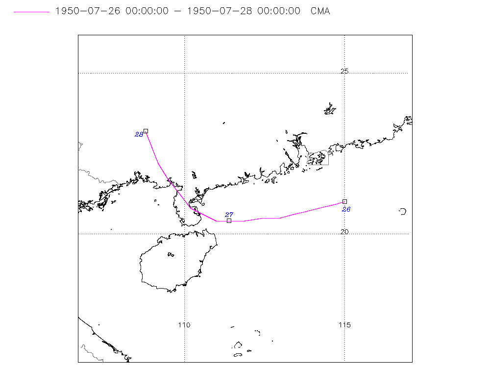
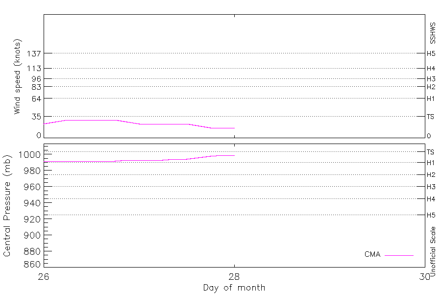
Summary Information
|
|
| Storm ID |
1950207N21115 |
| Start |
Jul 26 00Z |
| Landfall |
Jul 27 09Z |
| Max Intensity |
29 kt (Jul 26 06Z), 992 mb (Jul 26 03Z) |
| End |
Jul 28 00Z |
| ATCF IDs |
|
| Track status |
Best track data. |
|
Storm track plot
|
Intensity plots
|
Radial wind information
No radial wind information for this storm
|
Position and Intensity Table
| BASIN |
ISO_TIME_________ |
NATURE |
LAT |
LON |
CMA WIND |
CMA PRES |
| |
|
|
degrees north |
degrees east |
kts |
mb |
| WP |
1950-07-26 00:00:00 |
TS |
21.00 |
115.00 |
23 |
992 |
| WP |
03:00:00 |
TS |
20.90 |
114.60 |
26 |
992 |
| WP |
06:00:00 |
TS |
20.80 |
114.20 |
29 |
992 |
| WP |
09:00:00 |
TS |
20.70 |
113.80 |
29 |
992 |
| WP |
12:00:00 |
TS |
20.60 |
113.40 |
29 |
992 |
| WP |
15:00:00 |
TS |
20.50 |
113.00 |
29 |
992 |
| WP |
18:00:00 |
TS |
20.50 |
112.50 |
29 |
992 |
| WP |
21:00:00 |
TS |
20.40 |
111.90 |
26 |
993 |
| WP |
1950-07-27 00:00:00 |
TS |
20.40 |
111.40 |
23 |
993 |
| WP |
03:00:00 |
TS |
20.40 |
111.00 |
23 |
993 |
| WP |
06:00:00 |
TS |
20.60 |
110.60 |
23 |
993 |
| WP |
09:00:00 |
TS |
20.80 |
110.20 |
23 |
994 |
| WP |
12:00:00 |
TS |
21.20 |
109.90 |
23 |
994 |
| WP |
15:00:00 |
TS |
21.70 |
109.50 |
20 |
996 |
| WP |
18:00:00 |
DS |
22.20 |
109.20 |
17 |
998 |
| WP |
21:00:00 |
DS |
22.70 |
109.00 |
17 |
999 |
| WP |
1950-07-28 00:00:00 |
DS |
23.20 |
108.80 |
17 |
999 |
Source Information
| Agency |
Information |
| USA |
|
| TOKYO |
|
| CMA |
CH1950BST.txt:Storm=12:(nameless) |
| HKO |
|
| KMA |
|
| NEWDELHI |
|
| REUNION |
|
| BOM |
|
| NADI |
|
| WELLINGTON |
|
| DS824 |
|
| TD9636 |
|
| TD9635 |
|
| NEUMANN |
|
| MLC |
|
All available IBTrACS Data
| SEASON |
BASIN |
SUBBASIN |
ISO_TIME_________ |
NATURE |
LAT |
LON |
DIST2LAND |
LANDFALL |
IFLAG |
USA SSHS |
CMA LAT |
CMA LON |
CMA CAT |
CMA WIND |
CMA PRES |
STORM SPEED |
STORM DIR |
| Year |
|
|
|
|
degrees north |
degrees east |
km |
km |
|
1 |
degrees north |
degrees east |
1 |
kts |
mb |
kts |
degrees |
| 1950 |
WP |
MM |
1950-07-26 00:00:00 |
TS |
21.00 |
115.00 |
162 |
154 |
__O____________ |
-5 |
21.00 |
115.00 |
1 |
23 |
992 |
8 |
255 |
| 1950 |
WP |
MM |
03:00:00 |
TS |
20.90 |
114.60 |
159 |
156 |
__P____________ |
-5 |
20.90 |
114.60 |
1 |
26 |
992 |
8 |
255 |
| 1950 |
WP |
MM |
06:00:00 |
TS |
20.80 |
114.20 |
168 |
157 |
__O____________ |
-5 |
20.80 |
114.20 |
1 |
29 |
992 |
8 |
255 |
| 1950 |
WP |
MM |
09:00:00 |
TS |
20.70 |
113.80 |
157 |
151 |
__P____________ |
-5 |
20.70 |
113.80 |
1 |
29 |
992 |
8 |
255 |
| 1950 |
WP |
MM |
12:00:00 |
TS |
20.60 |
113.40 |
151 |
140 |
__O____________ |
-5 |
20.60 |
113.40 |
1 |
29 |
992 |
8 |
260 |
| 1950 |
WP |
MM |
15:00:00 |
TS |
20.50 |
113.00 |
151 |
135 |
__P____________ |
-5 |
20.50 |
113.00 |
1 |
29 |
992 |
8 |
265 |
| 1950 |
WP |
MM |
18:00:00 |
TS |
20.50 |
112.50 |
135 |
127 |
__O____________ |
-5 |
20.50 |
112.50 |
1 |
29 |
992 |
10 |
265 |
| 1950 |
WP |
MM |
21:00:00 |
TS |
20.40 |
111.90 |
118 |
76 |
__P____________ |
-5 |
20.40 |
111.90 |
1 |
26 |
993 |
10 |
265 |
| 1950 |
WP |
MM |
1950-07-27 00:00:00 |
TS |
20.40 |
111.40 |
76 |
45 |
__O____________ |
-5 |
20.40 |
111.40 |
1 |
23 |
993 |
9 |
270 |
| 1950 |
WP |
MM |
03:00:00 |
TS |
20.40 |
111.00 |
45 |
15 |
__P____________ |
-5 |
20.40 |
111.00 |
1 |
23 |
993 |
8 |
285 |
| 1950 |
WP |
MM |
06:00:00 |
TS |
20.60 |
110.60 |
15 |
0 |
__O____________ |
-5 |
20.60 |
110.60 |
1 |
23 |
993 |
8 |
300 |
| 1950 |
WP |
MM |
09:00:00 |
TS |
20.80 |
110.20 |
0 |
0 |
__P____________ |
-5 |
20.80 |
110.20 |
1 |
23 |
994 |
9 |
315 |
| 1950 |
WP |
MM |
12:00:00 |
TS |
21.20 |
109.90 |
0 |
0 |
__O____________ |
-5 |
21.20 |
109.90 |
1 |
23 |
994 |
11 |
320 |
| 1950 |
WP |
MM |
15:00:00 |
TS |
21.70 |
109.50 |
0 |
0 |
__P____________ |
-5 |
21.70 |
109.50 |
1 |
20 |
996 |
12 |
325 |
| 1950 |
WP |
MM |
18:00:00 |
DS |
22.20 |
109.20 |
0 |
0 |
__O____________ |
-5 |
22.20 |
109.20 |
0 |
17 |
998 |
12 |
335 |
| 1950 |
WP |
MM |
21:00:00 |
DS |
22.70 |
109.00 |
0 |
0 |
__P____________ |
-5 |
22.70 |
109.00 |
0 |
17 |
999 |
11 |
340 |
| 1950 |
WP |
MM |
1950-07-28 00:00:00 |
DS |
23.20 |
108.80 |
0 |
|
__O____________ |
-5 |
23.20 |
108.80 |
0 |
17 |
999 |
10 |
340 |