1952
Tropical Storm UNNAMED (1952260N17119)
IBTrACS version v04r01. Visit
IBTrACS website for data access.
Please direct all questions to the
IBTrACS Q and A forum
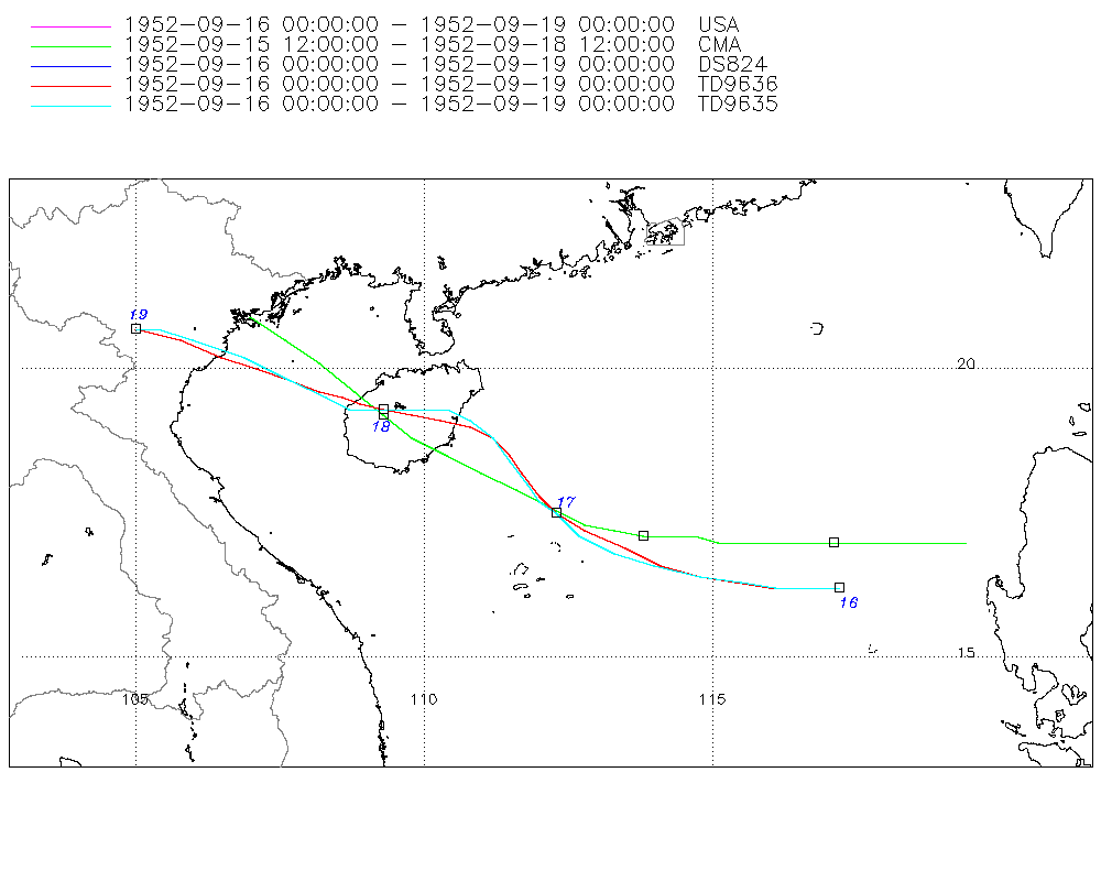
Storm track
-
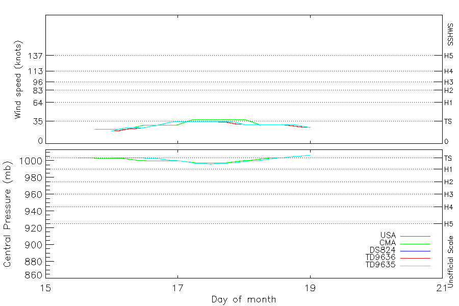
Intensity
-
Wind Radii
-
Intensity Data
-
Source Data
-
All data
Summary Information
|
|
| Storm ID |
1952260N17119 |
| Start |
Sep 15 12Z |
| Landfall |
Sep 17 18Z, Sep 18 18Z |
| Max Intensity |
38 kt (Sep 17 06Z), 996 mb (Sep 17 12Z) |
| End |
Sep 19 00Z |
| ATCF IDs |
,WP141952 |
| Track status |
Best track data. |
|
Storm track plot
|
Intensity plots
|
Radial wind information
|
Position and Intensity Table
| BASIN |
ISO_TIME_________ |
NATURE |
LAT |
LON |
USA WIND |
CMA WIND |
CMA PRES |
DS824 WIND |
TD9636 WIND |
TD9635 WIND |
TD9635 PRES |
| |
|
|
degrees north |
degrees east |
kts |
kts |
mb |
kts |
kts |
kts |
mb |
| WP |
1952-09-15 12:00:00 |
DS |
17.00 |
119.40 |
|
|
1004 |
|
|
|
|
| WP |
15:00:00 |
DS |
17.00 |
118.70 |
|
|
1004 |
|
|
|
|
| WP |
18:00:00 |
TS |
17.00 |
118.00 |
|
23 |
1003 |
|
|
|
|
| WP |
21:00:00 |
TS |
17.00 |
117.50 |
|
23 |
1003 |
|
|
|
|
| WP |
1952-09-16 00:00:00 |
TS |
16.60 |
117.20 |
20 |
23 |
1003 |
20 |
20 |
20 |
1004 |
| WP |
03:00:00 |
TS |
16.50 |
116.70 |
23 |
23 |
1003 |
23 |
21 |
23 |
1004 |
| WP |
06:00:00 |
TS |
16.40 |
116.10 |
25 |
23 |
1002 |
25 |
23 |
25 |
1004 |
| WP |
09:00:00 |
TS |
16.40 |
115.60 |
25 |
26 |
1001 |
25 |
24 |
25 |
1004 |
| WP |
12:00:00 |
TS |
16.50 |
114.90 |
25 |
29 |
1000 |
25 |
25 |
25 |
1003 |
| WP |
15:00:00 |
TS |
16.70 |
114.30 |
28 |
29 |
1000 |
28 |
28 |
28 |
1003 |
| WP |
18:00:00 |
TS |
16.90 |
113.60 |
30 |
29 |
1000 |
30 |
30 |
30 |
1002 |
| WP |
21:00:00 |
TS |
17.10 |
113.10 |
33 |
29 |
1000 |
33 |
33 |
33 |
1001 |
| WP |
1952-09-17 00:00:00 |
TS |
17.40 |
112.60 |
35 |
29 |
1000 |
35 |
35 |
35 |
1000 |
| WP |
03:00:00 |
TS |
17.60 |
112.30 |
35 |
34 |
999 |
35 |
35 |
35 |
999 |
| WP |
06:00:00 |
TS |
17.90 |
112.00 |
35 |
38 |
998 |
35 |
35 |
35 |
997 |
| WP |
09:00:00 |
TS |
18.30 |
111.70 |
35 |
38 |
998 |
35 |
35 |
35 |
997 |
| WP |
12:00:00 |
TS |
18.60 |
111.30 |
35 |
38 |
998 |
35 |
35 |
35 |
996 |
| WP |
15:00:00 |
TS |
18.90 |
110.90 |
35 |
38 |
998 |
35 |
34 |
35 |
997 |
| WP |
18:00:00 |
TS |
19.10 |
110.40 |
35 |
38 |
998 |
35 |
33 |
35 |
997 |
| WP |
21:00:00 |
TS |
19.20 |
109.80 |
33 |
38 |
999 |
33 |
31 |
33 |
998 |
| WP |
1952-09-18 00:00:00 |
TS |
19.30 |
109.30 |
30 |
38 |
1000 |
30 |
30 |
30 |
999 |
| WP |
03:00:00 |
TS |
19.40 |
108.90 |
30 |
34 |
1001 |
30 |
30 |
30 |
1000 |
| WP |
06:00:00 |
TS |
19.50 |
108.60 |
30 |
29 |
1002 |
30 |
30 |
30 |
1000 |
| WP |
09:00:00 |
TS |
19.60 |
108.20 |
30 |
|
1003 |
30 |
30 |
30 |
1002 |
| WP |
12:00:00 |
MX |
19.90 |
107.70 |
30 |
|
1004 |
30 |
30 |
30 |
1003 |
| WP |
15:00:00 |
TS |
20.10 |
106.90 |
30 |
|
|
30 |
29 |
30 |
1004 |
| WP |
18:00:00 |
TS |
20.40 |
106.10 |
30 |
|
|
30 |
28 |
30 |
1005 |
| WP |
21:00:00 |
TS |
20.60 |
105.50 |
28 |
|
|
28 |
26 |
28 |
1006 |
| WP |
1952-09-19 00:00:00 |
TS |
20.70 |
105.00 |
25 |
|
|
25 |
25 |
25 |
1007 |
Source Information
| Agency |
Information |
| USA |
bwp141952.txt |
| TOKYO |
|
| CMA |
CH1952BST.txt:Storm=21:(nameless) |
| HKO |
|
| KMA |
|
| NEWDELHI |
|
| REUNION |
|
| BOM |
|
| NADI |
|
| WELLINGTON |
|
| DS824 |
w_npac.dat:164:14W |
| TD9636 |
cons_worldwide_trop_cyclone_18710101-19891231-003:Line=16026 |
| TD9635 |
typhoons-analogs_19450101-19761231.corrected:Line=8369 |
| NEUMANN |
|
| MLC |
|
All available IBTrACS Data
| SEASON |
BASIN |
SUBBASIN |
ISO_TIME_________ |
NATURE |
LAT |
LON |
DIST2LAND |
LANDFALL |
IFLAG |
USA AGENCY |
USA ATCF_ID |
USA LAT |
USA LON |
USA WIND |
USA SSHS |
CMA LAT |
CMA LON |
CMA CAT |
CMA WIND |
CMA PRES |
DS824 LAT |
DS824 LON |
DS824 STAGE |
DS824 WIND |
TD9636 LAT |
TD9636 LON |
TD9636 STAGE |
TD9636 WIND |
TD9635 LAT |
TD9635 LON |
TD9635 WIND |
TD9635 PRES |
TD9635 ROCI |
STORM SPEED |
STORM DIR |
| Year |
|
|
|
|
degrees north |
degrees east |
km |
km |
|
|
|
degrees north |
degrees east |
kts |
1 |
degrees north |
degrees east |
1 |
kts |
mb |
degrees north |
degrees east |
|
kts |
degrees north |
degrees east |
|
kts |
degrees north |
degrees east |
kts |
mb |
nmile |
kts |
degrees |
| 1952 |
WP |
MM |
1952-09-15 12:00:00 |
DS |
17.00 |
119.40 |
89 |
89 |
__O____________ |
|
|
|
|
|
-5 |
17.00 |
119.40 |
0 |
|
1004 |
|
|
|
|
|
|
|
|
|
|
|
|
|
14 |
270 |
| 1952 |
WP |
MM |
15:00:00 |
DS |
17.00 |
118.70 |
140 |
140 |
__P____________ |
|
|
|
|
|
-5 |
17.00 |
118.70 |
0 |
|
1004 |
|
|
|
|
|
|
|
|
|
|
|
|
|
13 |
270 |
| 1952 |
WP |
MM |
18:00:00 |
TS |
17.00 |
118.00 |
207 |
207 |
__O____________ |
|
|
|
|
|
-5 |
17.00 |
118.00 |
1 |
23 |
1003 |
|
|
|
|
|
|
|
|
|
|
|
|
|
11 |
270 |
| 1952 |
WP |
MM |
21:00:00 |
TS |
17.00 |
117.50 |
257 |
257 |
__P____________ |
|
|
|
|
|
-5 |
17.00 |
117.50 |
1 |
23 |
1003 |
|
|
|
|
|
|
|
|
|
|
|
|
|
9 |
245 |
| 1952 |
WP |
MM |
1952-09-16 00:00:00 |
TS |
16.60 |
117.20 |
275 |
275 |
O_O_______OOO__ |
jtwc_wp |
WP141952 |
16.20 |
117.20 |
20 |
-1 |
17.00 |
117.10 |
1 |
23 |
1003 |
16.20 |
117.20 |
TC |
20 |
16.20 |
117.20 |
1 |
20 |
16.20 |
117.20 |
20 |
1004 |
120 |
10 |
235 |
| 1952 |
WP |
MM |
03:00:00 |
TS |
16.50 |
116.70 |
325 |
325 |
P_P_______PPP__ |
|
WP141952 |
16.20 |
116.70 |
23 |
-1 |
17.00 |
116.70 |
1 |
23 |
1003 |
16.20 |
116.70 |
TC |
23 |
16.20 |
116.60 |
1 |
21 |
16.20 |
116.70 |
23 |
1004 |
150 |
10 |
260 |
| 1952 |
WP |
MM |
06:00:00 |
TS |
16.40 |
116.10 |
387 |
387 |
O_O_______OPO__ |
jtwc_wp |
WP141952 |
16.20 |
116.10 |
25 |
-1 |
17.00 |
116.30 |
1 |
23 |
1002 |
16.20 |
116.10 |
TC |
25 |
16.20 |
116.00 |
1 |
23 |
16.20 |
116.10 |
25 |
1004 |
180 |
11 |
270 |
| 1952 |
WP |
MM |
09:00:00 |
TS |
16.40 |
115.60 |
440 |
440 |
P_P_______PPP__ |
|
WP141952 |
16.30 |
115.50 |
25 |
-1 |
17.00 |
115.90 |
1 |
26 |
1001 |
16.30 |
115.50 |
TC |
25 |
16.30 |
115.40 |
1 |
24 |
16.30 |
115.50 |
25 |
1004 |
150 |
12 |
275 |
| 1952 |
WP |
MM |
12:00:00 |
TS |
16.50 |
114.90 |
515 |
466 |
O_O_______OOO__ |
jtwc_wp |
WP141952 |
16.40 |
114.80 |
25 |
-1 |
17.00 |
115.50 |
1 |
29 |
1000 |
16.40 |
114.80 |
TC |
25 |
16.40 |
114.80 |
1 |
25 |
16.40 |
114.80 |
25 |
1003 |
120 |
13 |
280 |
| 1952 |
WP |
MM |
15:00:00 |
TS |
16.70 |
114.30 |
466 |
390 |
P_P_______PPP__ |
|
WP141952 |
16.60 |
114.00 |
28 |
-1 |
17.00 |
115.10 |
1 |
29 |
1000 |
16.60 |
114.00 |
TC |
28 |
16.60 |
114.10 |
1 |
28 |
16.60 |
114.00 |
28 |
1003 |
150 |
13 |
285 |
| 1952 |
WP |
MM |
18:00:00 |
TS |
16.90 |
113.60 |
390 |
334 |
O_O_______OPO__ |
jtwc_wp |
WP141952 |
16.80 |
113.30 |
30 |
-1 |
17.10 |
114.70 |
1 |
29 |
1000 |
16.80 |
113.30 |
TC |
30 |
16.90 |
113.50 |
1 |
30 |
16.80 |
113.30 |
30 |
1002 |
180 |
13 |
290 |
| 1952 |
WP |
MM |
21:00:00 |
TS |
17.10 |
113.10 |
334 |
271 |
P_P_______PPP__ |
|
WP141952 |
17.10 |
112.70 |
33 |
-1 |
17.10 |
114.30 |
1 |
29 |
1000 |
17.10 |
112.70 |
TC |
33 |
17.20 |
112.80 |
1 |
33 |
17.10 |
112.70 |
33 |
1001 |
180 |
11 |
300 |
| 1952 |
WP |
MM |
1952-09-17 00:00:00 |
TS |
17.40 |
112.60 |
271 |
232 |
O_O_______OOO__ |
jtwc_wp |
WP141952 |
17.50 |
112.30 |
35 |
0 |
17.10 |
113.80 |
1 |
29 |
1000 |
17.50 |
112.30 |
TC |
35 |
17.50 |
112.30 |
2 |
35 |
17.50 |
112.30 |
35 |
1000 |
180 |
9 |
305 |
| 1952 |
WP |
MM |
03:00:00 |
TS |
17.60 |
112.30 |
232 |
187 |
P_P_______PPP__ |
|
WP141952 |
17.70 |
112.00 |
35 |
0 |
17.20 |
113.30 |
1 |
34 |
999 |
17.70 |
112.00 |
TC |
35 |
17.80 |
112.00 |
2 |
35 |
17.70 |
112.00 |
35 |
999 |
180 |
8 |
310 |
| 1952 |
WP |
MM |
06:00:00 |
TS |
17.90 |
112.00 |
187 |
143 |
O_O_______OPO__ |
jtwc_wp |
WP141952 |
18.00 |
111.80 |
35 |
0 |
17.30 |
112.80 |
2 |
38 |
998 |
18.00 |
111.80 |
TC |
35 |
18.20 |
111.70 |
2 |
35 |
18.00 |
111.80 |
35 |
997 |
180 |
9 |
315 |
| 1952 |
WP |
MM |
09:00:00 |
TS |
18.30 |
111.70 |
138 |
86 |
P_P_______PPP__ |
|
WP141952 |
18.40 |
111.50 |
35 |
0 |
17.60 |
112.20 |
2 |
38 |
998 |
18.40 |
111.50 |
TC |
35 |
18.50 |
111.50 |
2 |
35 |
18.40 |
111.50 |
35 |
997 |
210 |
10 |
315 |
| 1952 |
WP |
MM |
12:00:00 |
TS |
18.60 |
111.30 |
86 |
33 |
O_O_______OOO__ |
jtwc_wp |
WP141952 |
18.80 |
111.20 |
35 |
0 |
17.90 |
111.60 |
2 |
38 |
998 |
18.80 |
111.20 |
TC |
35 |
18.80 |
111.20 |
2 |
35 |
18.80 |
111.20 |
35 |
996 |
240 |
10 |
310 |
| 1952 |
WP |
MM |
15:00:00 |
TS |
18.90 |
110.90 |
33 |
0 |
P_P_______PPP__ |
|
WP141952 |
19.10 |
110.80 |
35 |
0 |
18.20 |
111.00 |
2 |
38 |
998 |
19.10 |
110.80 |
TC |
35 |
19.00 |
110.80 |
2 |
34 |
19.10 |
110.80 |
35 |
997 |
240 |
10 |
300 |
| 1952 |
WP |
MM |
18:00:00 |
TS |
19.10 |
110.40 |
0 |
0 |
O_O_______OPO__ |
jtwc_wp |
WP141952 |
19.30 |
110.40 |
35 |
0 |
18.50 |
110.40 |
2 |
38 |
998 |
19.30 |
110.40 |
TC |
35 |
19.10 |
110.30 |
2 |
33 |
19.30 |
110.40 |
35 |
997 |
240 |
10 |
290 |
| 1952 |
WP |
MM |
21:00:00 |
TS |
19.20 |
109.80 |
0 |
0 |
P_P_______PPP__ |
|
WP141952 |
19.30 |
109.80 |
33 |
-1 |
18.80 |
109.80 |
2 |
38 |
999 |
19.30 |
109.80 |
TC |
33 |
19.20 |
109.80 |
2 |
31 |
19.30 |
109.80 |
33 |
998 |
210 |
10 |
280 |
| 1952 |
WP |
MM |
1952-09-18 00:00:00 |
TS |
19.30 |
109.30 |
0 |
0 |
O_O_______OOO__ |
jtwc_wp |
WP141952 |
19.30 |
109.30 |
30 |
-1 |
19.20 |
109.30 |
2 |
38 |
1000 |
19.30 |
109.30 |
TC |
30 |
19.30 |
109.30 |
1 |
30 |
19.30 |
109.30 |
30 |
999 |
180 |
9 |
280 |
| 1952 |
WP |
MM |
03:00:00 |
TS |
19.40 |
108.90 |
0 |
0 |
P_P_______PPP__ |
|
WP141952 |
19.30 |
109.00 |
30 |
-1 |
19.60 |
108.80 |
2 |
34 |
1001 |
19.30 |
109.00 |
TC |
30 |
19.40 |
108.90 |
1 |
30 |
19.30 |
109.00 |
30 |
1000 |
210 |
7 |
285 |
| 1952 |
WP |
MM |
06:00:00 |
TS |
19.50 |
108.60 |
15 |
15 |
O_O_______OPO__ |
jtwc_wp |
WP141952 |
19.30 |
108.70 |
30 |
-1 |
20.10 |
108.20 |
1 |
29 |
1002 |
19.30 |
108.70 |
TC |
30 |
19.50 |
108.60 |
1 |
30 |
19.30 |
108.70 |
30 |
1000 |
240 |
8 |
290 |
| 1952 |
WP |
MM |
09:00:00 |
TS |
19.60 |
108.20 |
53 |
53 |
P_P_______PPP__ |
|
WP141952 |
19.50 |
108.30 |
30 |
-1 |
20.50 |
107.60 |
1 |
|
1003 |
19.50 |
108.30 |
TC |
30 |
19.60 |
108.20 |
1 |
30 |
19.50 |
108.30 |
30 |
1002 |
210 |
10 |
295 |
| 1952 |
WP |
MM |
12:00:00 |
MX |
19.90 |
107.70 |
115 |
47 |
O_O_______OOO__ |
jtwc_wp |
WP141952 |
19.80 |
107.70 |
30 |
-1 |
20.90 |
107.00 |
0 |
|
1004 |
19.80 |
107.70 |
TC |
30 |
19.80 |
107.70 |
1 |
30 |
19.80 |
107.70 |
30 |
1003 |
180 |
13 |
290 |
| 1952 |
WP |
MM |
15:00:00 |
TS |
20.10 |
106.90 |
38 |
0 |
P_________PPP__ |
|
WP141952 |
20.20 |
106.90 |
30 |
-1 |
|
|
|
|
|
20.20 |
106.90 |
TC |
30 |
20.00 |
107.10 |
1 |
29 |
20.20 |
106.90 |
30 |
1004 |
150 |
16 |
290 |
| 1952 |
WP |
MM |
18:00:00 |
TS |
20.40 |
106.10 |
0 |
0 |
O_________OPO__ |
jtwc_wp |
WP141952 |
20.50 |
106.00 |
30 |
-1 |
|
|
|
|
|
20.50 |
106.00 |
TC |
30 |
20.20 |
106.50 |
1 |
28 |
20.50 |
106.00 |
30 |
1005 |
120 |
14 |
290 |
| 1952 |
WP |
MM |
21:00:00 |
TS |
20.60 |
105.50 |
0 |
0 |
P_________PPP__ |
|
WP141952 |
20.70 |
105.40 |
28 |
-1 |
|
|
|
|
|
20.70 |
105.40 |
TC |
28 |
20.50 |
105.80 |
1 |
26 |
20.70 |
105.40 |
28 |
1006 |
120 |
11 |
285 |
| 1952 |
WP |
MM |
1952-09-19 00:00:00 |
TS |
20.70 |
105.00 |
0 |
|
O_________OOO__ |
jtwc_wp |
WP141952 |
20.70 |
105.00 |
25 |
-1 |
|
|
|
|
|
20.70 |
105.00 |
TC |
25 |
20.70 |
105.00 |
1 |
25 |
20.70 |
105.00 |
25 |
1007 |
120 |
9 |
280 |