1955
Tropical Depression UNNAMED (1955317N13115)
IBTrACS version v04r01. Visit
IBTrACS website for data access.
Please direct all questions to the
IBTrACS Q and A forum
Storm track
-
Intensity
-
Wind Radii
-
Intensity Data
-
Source Data
-
All data
Summary Information
|
|
| Storm ID |
1955317N13115 |
| Start |
Nov 13 00Z |
| Max Intensity |
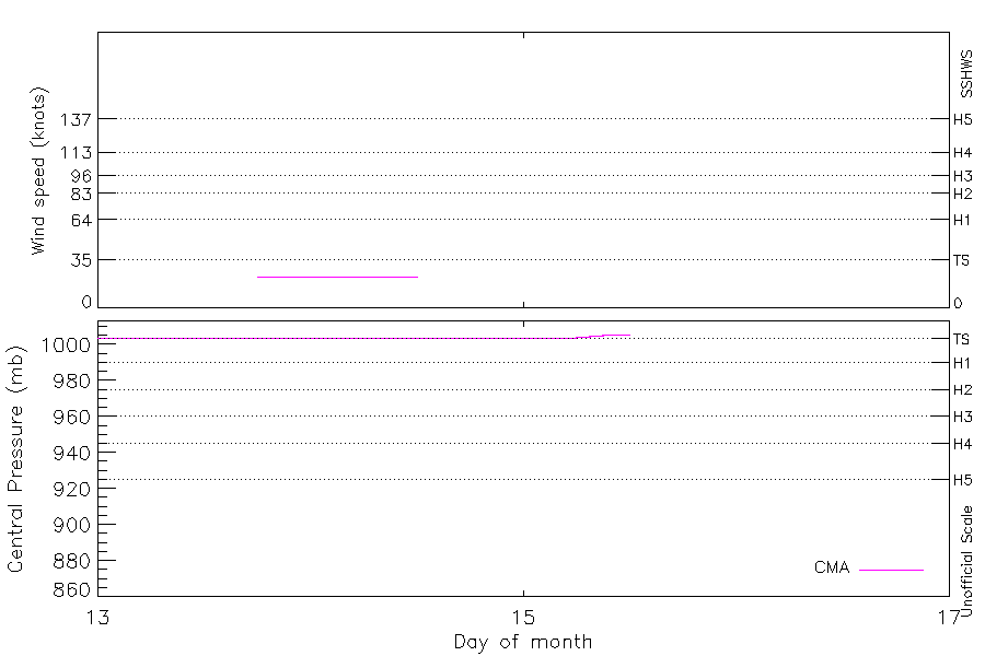
23 kt (Nov 13 18Z) |
| End |
Nov 15 12Z |
| ATCF IDs |
|
| Track status |
Best track data. |
|
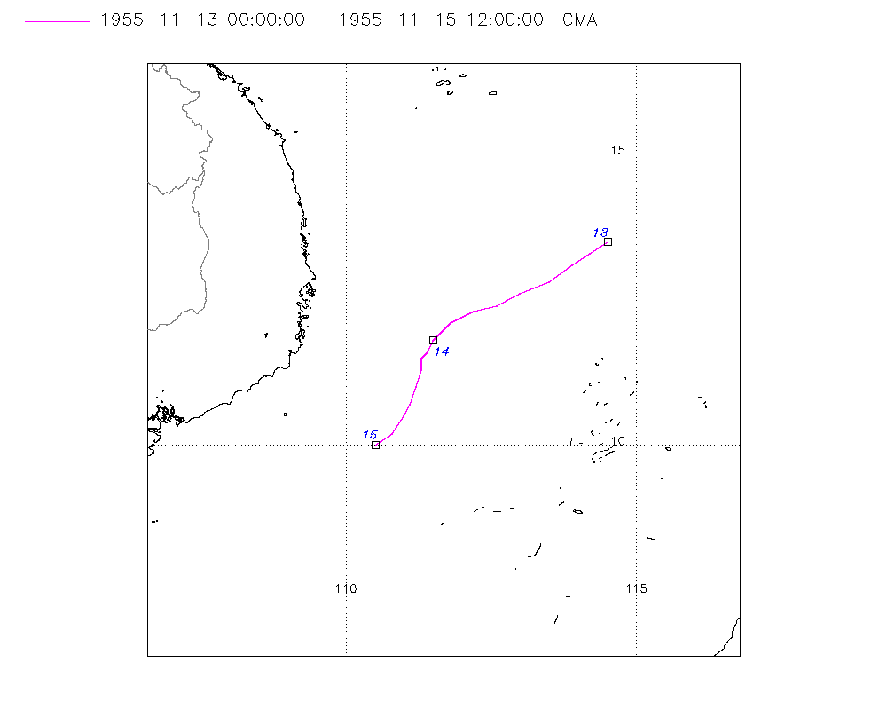
Storm track plot
|
Intensity plots
|
Radial wind information
No radial wind information for this storm
|
Position and Intensity Table
| BASIN |
ISO_TIME_________ |
NATURE |
LAT |
LON |
CMA WIND |
CMA PRES |
| |
|
|
degrees north |
degrees east |
kts |
mb |
| WP |
1955-11-13 00:00:00 |
DS |
13.50 |
114.50 |
|
1004 |
| WP |
03:00:00 |
DS |
13.30 |
114.20 |
|
1004 |
| WP |
06:00:00 |
DS |
13.10 |
113.90 |
|
1004 |
| WP |
09:00:00 |
DS |
12.80 |
113.50 |
|
1004 |
| WP |
12:00:00 |
DS |
12.60 |
113.00 |
|
1004 |
| WP |
15:00:00 |
DS |
12.40 |
112.60 |
|
1004 |
| WP |
18:00:00 |
TS |
12.30 |
112.20 |
23 |
1004 |
| WP |
21:00:00 |
TS |
12.10 |
111.80 |
23 |
1004 |
| WP |
1955-11-14 00:00:00 |
TS |
11.80 |
111.50 |
23 |
1004 |
| WP |
03:00:00 |
TS |
11.60 |
111.40 |
23 |
1004 |
| WP |
06:00:00 |
TS |
11.50 |
111.30 |
23 |
1004 |
| WP |
09:00:00 |
TS |
11.30 |
111.30 |
23 |
1004 |
| WP |
12:00:00 |
TS |
11.00 |
111.20 |
23 |
1004 |
| WP |
15:00:00 |
TS |
10.70 |
111.10 |
|
1004 |
| WP |
18:00:00 |
DS |
10.50 |
111.00 |
|
1004 |
| WP |
21:00:00 |
DS |
10.20 |
110.80 |
|
1004 |
| WP |
1955-11-15 00:00:00 |
DS |
10.00 |
110.50 |
|
1004 |
| WP |
03:00:00 |
DS |
10.00 |
110.30 |
|
1004 |
| WP |
06:00:00 |
DS |
10.00 |
110.00 |
|
1004 |
| WP |
09:00:00 |
DS |
10.00 |
109.70 |
|
1005 |
| WP |
12:00:00 |
DS |
10.00 |
109.50 |
|
1006 |
Source Information
| Agency |
Information |
| USA |
|
| TOKYO |
|
| CMA |
CH1955BST.txt:Storm=35:(nameless) |
| HKO |
|
| KMA |
|
| NEWDELHI |
|
| REUNION |
|
| BOM |
|
| NADI |
|
| WELLINGTON |
|
| DS824 |
|
| TD9636 |
|
| TD9635 |
|
| NEUMANN |
|
| MLC |
|
All available IBTrACS Data
| SEASON |
BASIN |
SUBBASIN |
ISO_TIME_________ |
NATURE |
LAT |
LON |
DIST2LAND |
LANDFALL |
IFLAG |
USA SSHS |
CMA LAT |
CMA LON |
CMA CAT |
CMA WIND |
CMA PRES |
STORM SPEED |
STORM DIR |
| Year |
|
|
|
|
degrees north |
degrees east |
km |
km |
|
1 |
degrees north |
degrees east |
1 |
kts |
mb |
kts |
degrees |
| 1955 |
WP |
MM |
1955-11-13 00:00:00 |
DS |
13.50 |
114.50 |
545 |
511 |
__O____________ |
-5 |
13.50 |
114.50 |
0 |
|
1004 |
6 |
235 |
| 1955 |
WP |
MM |
03:00:00 |
DS |
13.30 |
114.20 |
511 |
477 |
__P____________ |
-5 |
13.30 |
114.20 |
0 |
|
1004 |
7 |
235 |
| 1955 |
WP |
MM |
06:00:00 |
DS |
13.10 |
113.90 |
477 |
433 |
__O____________ |
-5 |
13.10 |
113.90 |
0 |
|
1004 |
9 |
240 |
| 1955 |
WP |
MM |
09:00:00 |
DS |
12.80 |
113.50 |
434 |
380 |
__P____________ |
-5 |
12.80 |
113.50 |
0 |
|
1004 |
10 |
240 |
| 1955 |
WP |
MM |
12:00:00 |
DS |
12.60 |
113.00 |
380 |
336 |
__O____________ |
-5 |
12.60 |
113.00 |
0 |
|
1004 |
9 |
245 |
| 1955 |
WP |
MM |
15:00:00 |
DS |
12.40 |
112.60 |
337 |
295 |
__P____________ |
-5 |
12.40 |
112.60 |
0 |
|
1004 |
8 |
250 |
| 1955 |
WP |
MM |
18:00:00 |
TS |
12.30 |
112.20 |
295 |
256 |
__O____________ |
-5 |
12.30 |
112.20 |
1 |
23 |
1004 |
9 |
240 |
| 1955 |
WP |
MM |
21:00:00 |
TS |
12.10 |
111.80 |
256 |
235 |
__P____________ |
-5 |
12.10 |
111.80 |
1 |
23 |
1004 |
9 |
235 |
| 1955 |
WP |
MM |
1955-11-14 00:00:00 |
TS |
11.80 |
111.50 |
235 |
225 |
__O____________ |
-5 |
11.80 |
111.50 |
1 |
23 |
1004 |
6 |
230 |
| 1955 |
WP |
MM |
03:00:00 |
TS |
11.60 |
111.40 |
231 |
220 |
__P____________ |
-5 |
11.60 |
111.40 |
1 |
23 |
1004 |
4 |
215 |
| 1955 |
WP |
MM |
06:00:00 |
TS |
11.50 |
111.30 |
222 |
222 |
__O____________ |
-5 |
11.50 |
111.30 |
1 |
23 |
1004 |
4 |
195 |
| 1955 |
WP |
MM |
09:00:00 |
TS |
11.30 |
111.30 |
228 |
217 |
__P____________ |
-5 |
11.30 |
111.30 |
1 |
23 |
1004 |
5 |
190 |
| 1955 |
WP |
MM |
12:00:00 |
TS |
11.00 |
111.20 |
230 |
230 |
__O____________ |
-5 |
11.00 |
111.20 |
1 |
23 |
1004 |
5 |
195 |
| 1955 |
WP |
MM |
15:00:00 |
TS |
10.70 |
111.10 |
235 |
231 |
__P____________ |
-5 |
10.70 |
111.10 |
1 |
|
1004 |
5 |
200 |
| 1955 |
WP |
MM |
18:00:00 |
DS |
10.50 |
111.00 |
238 |
232 |
__O____________ |
-5 |
10.50 |
111.00 |
0 |
|
1004 |
6 |
215 |
| 1955 |
WP |
MM |
21:00:00 |
DS |
10.20 |
110.80 |
238 |
226 |
__P____________ |
-5 |
10.20 |
110.80 |
0 |
|
1004 |
7 |
225 |
| 1955 |
WP |
MM |
1955-11-15 00:00:00 |
DS |
10.00 |
110.50 |
226 |
211 |
__O____________ |
-5 |
10.00 |
110.50 |
0 |
|
1004 |
6 |
245 |
| 1955 |
WP |
MM |
03:00:00 |
DS |
10.00 |
110.30 |
211 |
191 |
__P____________ |
-5 |
10.00 |
110.30 |
0 |
|
1004 |
5 |
270 |
| 1955 |
WP |
MM |
06:00:00 |
DS |
10.00 |
110.00 |
191 |
179 |
__O____________ |
-5 |
10.00 |
110.00 |
0 |
|
1004 |
5 |
275 |
| 1955 |
WP |
MM |
09:00:00 |
DS |
10.00 |
109.70 |
173 |
160 |
__P____________ |
-5 |
10.00 |
109.70 |
0 |
|
1005 |
5 |
270 |
| 1955 |
WP |
MM |
12:00:00 |
DS |
10.00 |
109.50 |
160 |
|
__O____________ |
-5 |
10.00 |
109.50 |
0 |
|
1006 |
5 |
265 |