1959
Tropical Depression UNNAMED (1959275N16120)
IBTrACS version v04r01. Visit
IBTrACS website for data access.
Please direct all questions to the
IBTrACS Q and A forum
Storm track
-
Intensity
-
Wind Radii
-
Intensity Data
-
Source Data
-
All data
Summary Information
|
|
| Storm ID |
1959275N16120 |
| Start |
Oct 2 00Z |
| Max Intensity |
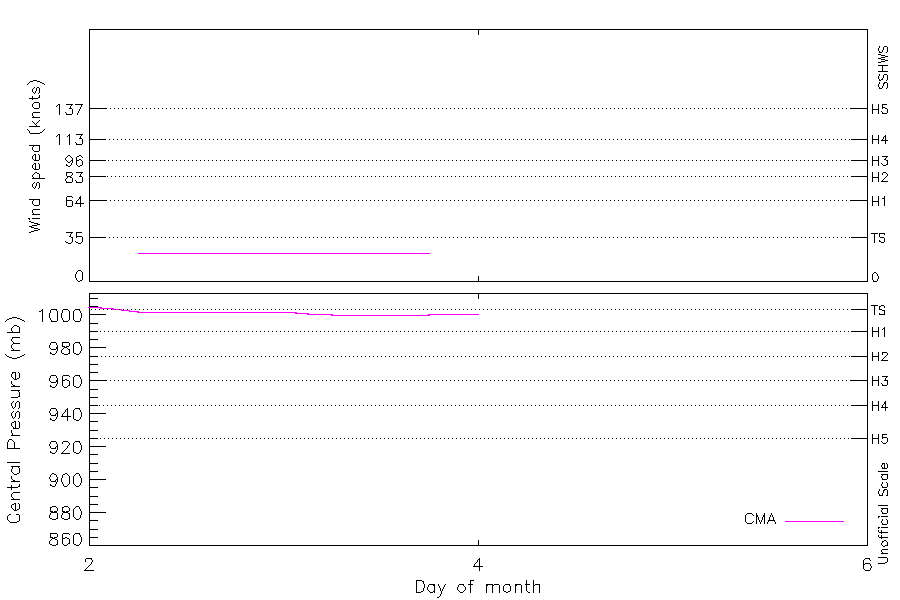
23 kt (Oct 2 06Z) |
| End |
Oct 4 00Z |
| ATCF IDs |
|
| Track status |
Best track data. |
|
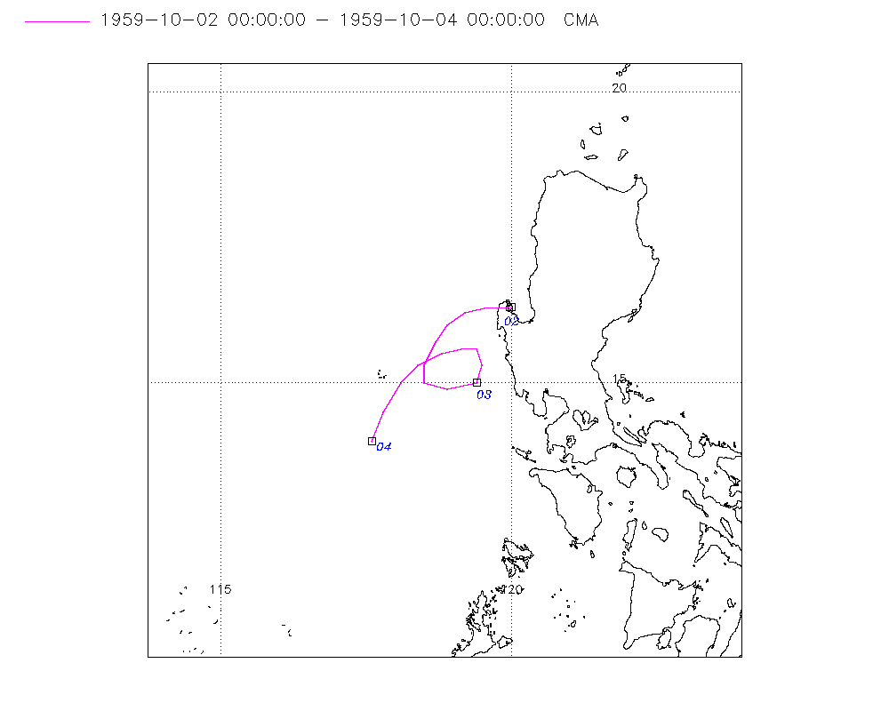
Storm track plot
|
Intensity plots
|
Radial wind information
No radial wind information for this storm
|
Position and Intensity Table
| BASIN |
ISO_TIME_________ |
NATURE |
LAT |
LON |
CMA WIND |
CMA PRES |
| |
|
|
degrees north |
degrees east |
kts |
mb |
| WP |
1959-10-02 00:00:00 |
DS |
16.30 |
120.00 |
|
1005 |
| WP |
03:00:00 |
DS |
16.30 |
119.60 |
|
1004 |
| WP |
06:00:00 |
TS |
16.20 |
119.20 |
23 |
1002 |
| WP |
09:00:00 |
TS |
16.00 |
118.90 |
23 |
1002 |
| WP |
12:00:00 |
TS |
15.70 |
118.70 |
23 |
1002 |
| WP |
15:00:00 |
TS |
15.30 |
118.50 |
23 |
1002 |
| WP |
18:00:00 |
TS |
15.00 |
118.50 |
23 |
1002 |
| WP |
21:00:00 |
TS |
14.90 |
118.90 |
23 |
1002 |
| WP |
1959-10-03 00:00:00 |
TS |
15.00 |
119.40 |
23 |
1002 |
| WP |
03:00:00 |
TS |
15.30 |
119.50 |
23 |
1001 |
| WP |
06:00:00 |
TS |
15.60 |
119.40 |
23 |
1000 |
| WP |
09:00:00 |
TS |
15.60 |
119.20 |
23 |
1000 |
| WP |
12:00:00 |
TS |
15.50 |
118.80 |
23 |
1000 |
| WP |
15:00:00 |
TS |
15.30 |
118.40 |
23 |
1000 |
| WP |
18:00:00 |
TS |
15.00 |
118.10 |
23 |
1000 |
| WP |
21:00:00 |
TS |
14.50 |
117.80 |
|
1001 |
| WP |
1959-10-04 00:00:00 |
DS |
14.00 |
117.60 |
|
1001 |
Source Information
| Agency |
Information |
| USA |
|
| TOKYO |
|
| CMA |
CH1959BST.txt:Storm=23:(nameless) |
| HKO |
|
| KMA |
|
| NEWDELHI |
|
| REUNION |
|
| BOM |
|
| NADI |
|
| WELLINGTON |
|
| DS824 |
|
| TD9636 |
|
| TD9635 |
|
| NEUMANN |
|
| MLC |
|
All available IBTrACS Data
| SEASON |
BASIN |
SUBBASIN |
ISO_TIME_________ |
NATURE |
LAT |
LON |
DIST2LAND |
LANDFALL |
IFLAG |
USA SSHS |
CMA LAT |
CMA LON |
CMA CAT |
CMA WIND |
CMA PRES |
STORM SPEED |
STORM DIR |
| Year |
|
|
|
|
degrees north |
degrees east |
km |
km |
|
1 |
degrees north |
degrees east |
1 |
kts |
mb |
kts |
degrees |
| 1959 |
WP |
MM |
1959-10-02 00:00:00 |
DS |
16.30 |
120.00 |
10 |
0 |
__O____________ |
-5 |
16.30 |
120.00 |
0 |
|
1005 |
8 |
270 |
| 1959 |
WP |
MM |
03:00:00 |
DS |
16.30 |
119.60 |
21 |
21 |
__P____________ |
-5 |
16.30 |
119.60 |
0 |
|
1004 |
8 |
265 |
| 1959 |
WP |
MM |
06:00:00 |
TS |
16.20 |
119.20 |
57 |
57 |
__O____________ |
-5 |
16.20 |
119.20 |
1 |
23 |
1002 |
7 |
245 |
| 1959 |
WP |
MM |
09:00:00 |
TS |
16.00 |
118.90 |
85 |
85 |
__P____________ |
-5 |
16.00 |
118.90 |
1 |
23 |
1002 |
7 |
225 |
| 1959 |
WP |
MM |
12:00:00 |
TS |
15.70 |
118.70 |
112 |
112 |
__O____________ |
-5 |
15.70 |
118.70 |
1 |
23 |
1002 |
8 |
210 |
| 1959 |
WP |
MM |
15:00:00 |
TS |
15.30 |
118.50 |
150 |
150 |
__P____________ |
-5 |
15.30 |
118.50 |
1 |
23 |
1002 |
7 |
195 |
| 1959 |
WP |
MM |
18:00:00 |
TS |
15.00 |
118.50 |
156 |
121 |
__O____________ |
-5 |
15.00 |
118.50 |
1 |
23 |
1002 |
6 |
135 |
| 1959 |
WP |
MM |
21:00:00 |
TS |
14.90 |
118.90 |
121 |
69 |
__P____________ |
-5 |
14.90 |
118.90 |
1 |
23 |
1002 |
9 |
90 |
| 1959 |
WP |
MM |
1959-10-03 00:00:00 |
TS |
15.00 |
119.40 |
69 |
44 |
__O____________ |
-5 |
15.00 |
119.40 |
1 |
23 |
1002 |
7 |
55 |
| 1959 |
WP |
MM |
03:00:00 |
TS |
15.30 |
119.50 |
44 |
42 |
__P____________ |
-5 |
15.30 |
119.50 |
1 |
23 |
1001 |
6 |
0 |
| 1959 |
WP |
MM |
06:00:00 |
TS |
15.60 |
119.40 |
54 |
54 |
__O____________ |
-5 |
15.60 |
119.40 |
1 |
23 |
1000 |
5 |
315 |
| 1959 |
WP |
MM |
09:00:00 |
TS |
15.60 |
119.20 |
69 |
69 |
__P____________ |
-5 |
15.60 |
119.20 |
1 |
23 |
1000 |
6 |
260 |
| 1959 |
WP |
MM |
12:00:00 |
TS |
15.50 |
118.80 |
111 |
111 |
__O____________ |
-5 |
15.50 |
118.80 |
1 |
23 |
1000 |
8 |
245 |
| 1959 |
WP |
MM |
15:00:00 |
TS |
15.30 |
118.40 |
159 |
159 |
__P____________ |
-5 |
15.30 |
118.40 |
1 |
23 |
1000 |
8 |
235 |
| 1959 |
WP |
MM |
18:00:00 |
TS |
15.00 |
118.10 |
198 |
198 |
__O____________ |
-5 |
15.00 |
118.10 |
1 |
23 |
1000 |
10 |
215 |
| 1959 |
WP |
MM |
21:00:00 |
TS |
14.50 |
117.80 |
247 |
247 |
__P____________ |
-5 |
14.50 |
117.80 |
1 |
|
1001 |
11 |
205 |
| 1959 |
WP |
MM |
1959-10-04 00:00:00 |
DS |
14.00 |
117.60 |
283 |
|
__O____________ |
-5 |
14.00 |
117.60 |
0 |
|
1001 |
12 |
200 |