1960
Tropical Depression UNNAMED (1960218N18119)
IBTrACS version v04r01. Visit
IBTrACS website for data access.
Please direct all questions to the
IBTrACS Q and A forum
Storm track
-
Intensity
-
Wind Radii
-
Intensity Data
-
Source Data
-
All data
Summary Information
|
|
| Storm ID |
1960218N18119 |
| Start |
Aug 5 06Z |
| Max Intensity |
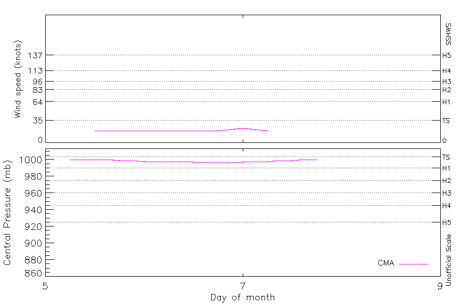
23 kt (Aug 7 00Z), 997 mb (Aug 6 12Z) |
| End |
Aug 7 18Z |
| ATCF IDs |
|
| Track status |
Best track data. |
|
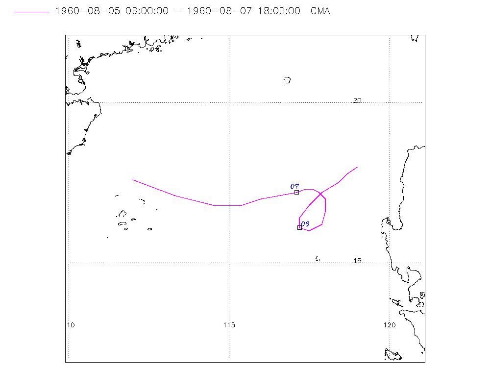
Storm track plot
|
Intensity plots
|
Radial wind information
No radial wind information for this storm
|
Position and Intensity Table
| BASIN |
ISO_TIME_________ |
NATURE |
LAT |
LON |
CMA WIND |
CMA PRES |
| |
|
|
degrees north |
degrees east |
kts |
mb |
| WP |
1960-08-05 06:00:00 |
DS |
18.00 |
119.00 |
|
1000 |
| WP |
09:00:00 |
DS |
17.80 |
118.70 |
|
1000 |
| WP |
12:00:00 |
DS |
17.50 |
118.40 |
19 |
1000 |
| WP |
15:00:00 |
DS |
17.20 |
117.90 |
19 |
1000 |
| WP |
18:00:00 |
DS |
16.80 |
117.50 |
19 |
999 |
| WP |
21:00:00 |
DS |
16.40 |
117.20 |
19 |
999 |
| WP |
1960-08-06 00:00:00 |
DS |
16.10 |
117.20 |
19 |
998 |
| WP |
03:00:00 |
DS |
16.00 |
117.50 |
19 |
998 |
| WP |
06:00:00 |
DS |
16.20 |
117.90 |
19 |
998 |
| WP |
09:00:00 |
DS |
16.60 |
118.00 |
19 |
998 |
| WP |
12:00:00 |
DS |
17.00 |
118.00 |
19 |
997 |
| WP |
15:00:00 |
DS |
17.20 |
117.80 |
19 |
997 |
| WP |
18:00:00 |
DS |
17.30 |
117.60 |
19 |
997 |
| WP |
21:00:00 |
DS |
17.30 |
117.40 |
21 |
997 |
| WP |
1960-08-07 00:00:00 |
TS |
17.20 |
117.10 |
23 |
997 |
| WP |
03:00:00 |
TS |
17.10 |
116.60 |
21 |
998 |
| WP |
06:00:00 |
DS |
17.00 |
116.00 |
19 |
998 |
| WP |
09:00:00 |
DS |
16.80 |
115.40 |
|
999 |
| WP |
12:00:00 |
DS |
16.80 |
114.50 |
|
999 |
| WP |
15:00:00 |
DS |
17.10 |
113.30 |
|
1000 |
| WP |
18:00:00 |
DS |
17.60 |
112.00 |
|
1000 |
Source Information
| Agency |
Information |
| USA |
|
| TOKYO |
|
| CMA |
CH1960BST.txt:Storm=14:(nameless) |
| HKO |
|
| KMA |
|
| NEWDELHI |
|
| REUNION |
|
| BOM |
|
| NADI |
|
| WELLINGTON |
|
| DS824 |
|
| TD9636 |
|
| TD9635 |
|
| NEUMANN |
|
| MLC |
|
All available IBTrACS Data
| SEASON |
BASIN |
SUBBASIN |
ISO_TIME_________ |
NATURE |
LAT |
LON |
DIST2LAND |
LANDFALL |
IFLAG |
USA SSHS |
CMA LAT |
CMA LON |
CMA CAT |
CMA WIND |
CMA PRES |
STORM SPEED |
STORM DIR |
| Year |
|
|
|
|
degrees north |
degrees east |
km |
km |
|
1 |
degrees north |
degrees east |
1 |
kts |
mb |
kts |
degrees |
| 1960 |
WP |
MM |
1960-08-05 06:00:00 |
DS |
18.00 |
119.00 |
144 |
144 |
__O____________ |
-5 |
18.00 |
119.00 |
0 |
|
1000 |
7 |
225 |
| 1960 |
WP |
MM |
09:00:00 |
DS |
17.80 |
118.70 |
170 |
169 |
__P____________ |
-5 |
17.80 |
118.70 |
0 |
|
1000 |
8 |
230 |
| 1960 |
WP |
MM |
12:00:00 |
DS |
17.50 |
118.40 |
200 |
200 |
__O____________ |
-5 |
17.50 |
118.40 |
0 |
19 |
1000 |
10 |
230 |
| 1960 |
WP |
MM |
15:00:00 |
DS |
17.20 |
117.90 |
226 |
221 |
__P____________ |
-5 |
17.20 |
117.90 |
0 |
19 |
1000 |
11 |
230 |
| 1960 |
WP |
MM |
18:00:00 |
DS |
16.80 |
117.50 |
251 |
251 |
__O____________ |
-5 |
16.80 |
117.50 |
0 |
19 |
999 |
10 |
220 |
| 1960 |
WP |
MM |
21:00:00 |
DS |
16.40 |
117.20 |
270 |
267 |
__P____________ |
-5 |
16.40 |
117.20 |
0 |
19 |
999 |
8 |
200 |
| 1960 |
WP |
MM |
1960-08-06 00:00:00 |
DS |
16.10 |
117.20 |
267 |
235 |
__O____________ |
-5 |
16.10 |
117.20 |
0 |
19 |
998 |
5 |
140 |
| 1960 |
WP |
MM |
03:00:00 |
DS |
16.00 |
117.50 |
235 |
193 |
__P____________ |
-5 |
16.00 |
117.50 |
0 |
19 |
998 |
7 |
80 |
| 1960 |
WP |
MM |
06:00:00 |
DS |
16.20 |
117.90 |
193 |
184 |
__O____________ |
-5 |
16.20 |
117.90 |
0 |
19 |
998 |
7 |
40 |
| 1960 |
WP |
MM |
09:00:00 |
DS |
16.60 |
118.00 |
193 |
193 |
__P____________ |
-5 |
16.60 |
118.00 |
0 |
19 |
998 |
8 |
5 |
| 1960 |
WP |
MM |
12:00:00 |
DS |
17.00 |
118.00 |
207 |
207 |
__O____________ |
-5 |
17.00 |
118.00 |
0 |
19 |
997 |
7 |
345 |
| 1960 |
WP |
MM |
15:00:00 |
DS |
17.20 |
117.80 |
235 |
235 |
__P____________ |
-5 |
17.20 |
117.80 |
0 |
19 |
997 |
5 |
310 |
| 1960 |
WP |
MM |
18:00:00 |
DS |
17.30 |
117.60 |
259 |
259 |
__O____________ |
-5 |
17.30 |
117.60 |
0 |
19 |
997 |
4 |
280 |
| 1960 |
WP |
MM |
21:00:00 |
DS |
17.30 |
117.40 |
278 |
278 |
__P____________ |
-5 |
17.30 |
117.40 |
0 |
21 |
997 |
5 |
260 |
| 1960 |
WP |
MM |
1960-08-07 00:00:00 |
TS |
17.20 |
117.10 |
304 |
304 |
__O____________ |
-5 |
17.20 |
117.10 |
1 |
23 |
997 |
8 |
255 |
| 1960 |
WP |
MM |
03:00:00 |
TS |
17.10 |
116.60 |
352 |
352 |
__P____________ |
-5 |
17.10 |
116.60 |
1 |
21 |
998 |
11 |
260 |
| 1960 |
WP |
MM |
06:00:00 |
DS |
17.00 |
116.00 |
410 |
410 |
__O____________ |
-5 |
17.00 |
116.00 |
0 |
19 |
998 |
12 |
255 |
| 1960 |
WP |
MM |
09:00:00 |
DS |
16.80 |
115.40 |
467 |
467 |
__P____________ |
-5 |
16.80 |
115.40 |
0 |
|
999 |
15 |
260 |
| 1960 |
WP |
MM |
12:00:00 |
DS |
16.80 |
114.50 |
479 |
360 |
__O____________ |
-5 |
16.80 |
114.50 |
0 |
|
999 |
19 |
280 |
| 1960 |
WP |
MM |
15:00:00 |
DS |
17.10 |
113.30 |
352 |
215 |
__P____________ |
-5 |
17.10 |
113.30 |
0 |
|
1000 |
25 |
290 |
| 1960 |
WP |
MM |
18:00:00 |
DS |
17.60 |
112.00 |
207 |
|
__O____________ |
-5 |
17.60 |
112.00 |
0 |
|
1000 |
28 |
290 |