1961
Tropical Depression UNNAMED (1961226N14126)
IBTrACS version v04r01. Visit
IBTrACS website for data access.
Please direct all questions to the
IBTrACS Q and A forum
Storm track
-
Intensity
-
Wind Radii
-
Intensity Data
-
Source Data
-
All data
Summary Information
|
|
| Storm ID |
1961226N14126 |
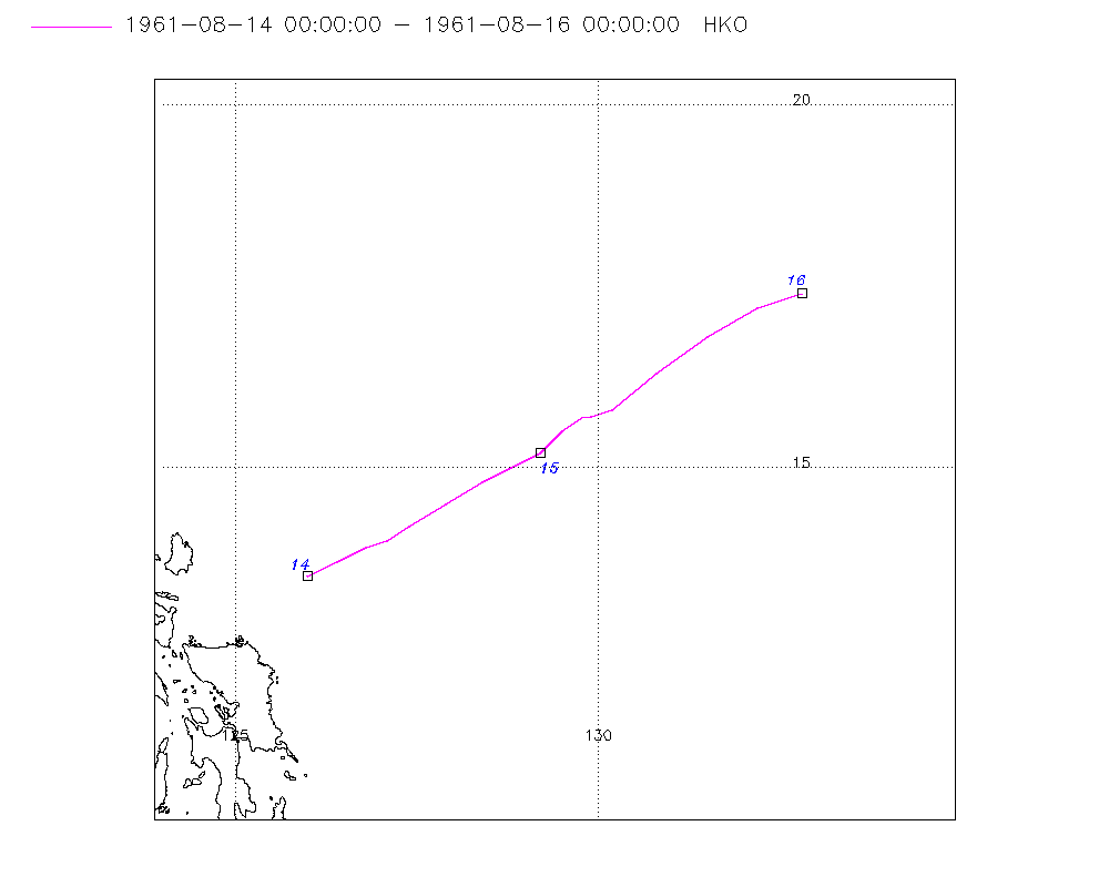
| Start |
Aug 14 00Z |
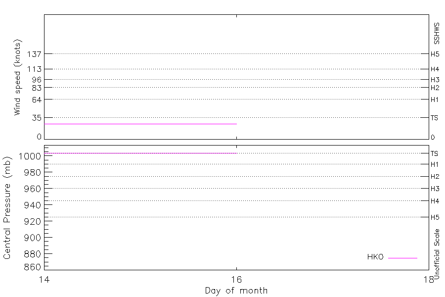
| Max Intensity |
25 kt (Aug 14 03Z) |
| End |
Aug 16 00Z |
| ATCF IDs |
|
| Track status |
Best track data. |
|
Storm track plot
|
Intensity plots
|
Radial wind information
No radial wind information for this storm
|
Position and Intensity Table
| BASIN |
ISO_TIME_________ |
NATURE |
LAT |
LON |
HKO WIND |
HKO PRES |
| |
|
|
degrees north |
degrees east |
kts |
mb |
| WP |
1961-08-14 00:00:00 |
TS |
13.50 |
126.00 |
25 |
1004 |
| WP |
03:00:00 |
TS |
13.70 |
126.40 |
25 |
1004 |
| WP |
06:00:00 |
TS |
13.90 |
126.80 |
25 |
1004 |
| WP |
09:00:00 |
TS |
14.00 |
127.10 |
25 |
1004 |
| WP |
12:00:00 |
TS |
14.20 |
127.40 |
25 |
1004 |
| WP |
15:00:00 |
TS |
14.50 |
127.90 |
25 |
1004 |
| WP |
18:00:00 |
TS |
14.80 |
128.40 |
25 |
1004 |
| WP |
21:00:00 |
TS |
15.00 |
128.80 |
25 |
1004 |
| WP |
1961-08-15 00:00:00 |
TS |
15.20 |
129.20 |
25 |
1004 |
| WP |
03:00:00 |
TS |
15.50 |
129.50 |
25 |
1004 |
| WP |
06:00:00 |
TS |
15.70 |
129.80 |
25 |
1004 |
| WP |
09:00:00 |
TS |
15.70 |
129.90 |
25 |
1004 |
| WP |
12:00:00 |
TS |
15.80 |
130.20 |
25 |
1004 |
| WP |
15:00:00 |
TS |
16.30 |
130.80 |
25 |
1004 |
| WP |
18:00:00 |
TS |
16.80 |
131.50 |
25 |
1004 |
| WP |
21:00:00 |
TS |
17.20 |
132.20 |
25 |
1004 |
| WP |
1961-08-16 00:00:00 |
TS |
17.40 |
132.80 |
25 |
1004 |
Source Information
| Agency |
Information |
| USA |
|
| TOKYO |
|
| CMA |
|
| HKO |
tc-besttrack-data-current.txt:Line=385:TD0814B |
| KMA |
|
| NEWDELHI |
|
| REUNION |
|
| BOM |
|
| NADI |
|
| WELLINGTON |
|
| DS824 |
|
| TD9636 |
|
| TD9635 |
|
| NEUMANN |
|
| MLC |
|
All available IBTrACS Data
| SEASON |
BASIN |
SUBBASIN |
ISO_TIME_________ |
NATURE |
LAT |
LON |
DIST2LAND |
LANDFALL |
IFLAG |
USA SSHS |
HKO LAT |
HKO LON |
HKO CAT |
HKO WIND |
HKO PRES |
STORM SPEED |
STORM DIR |
| Year |
|
|
|
|
degrees north |
degrees east |
km |
km |
|
1 |
degrees north |
degrees east |
|
kts |
mb |
kts |
degrees |
| 1961 |
WP |
MM |
1961-08-14 00:00:00 |
TS |
13.50 |
126.00 |
141 |
141 |
___O___________ |
-5 |
13.50 |
126.00 |
TD |
25 |
1004 |
9 |
60 |
| 1961 |
WP |
MM |
03:00:00 |
TS |
13.70 |
126.40 |
186 |
186 |
___P___________ |
-5 |
13.70 |
126.40 |
TD |
25 |
1004 |
9 |
65 |
| 1961 |
WP |
MM |
06:00:00 |
TS |
13.90 |
126.80 |
233 |
233 |
___O___________ |
-5 |
13.90 |
126.80 |
TD |
25 |
1004 |
7 |
65 |
| 1961 |
WP |
MM |
09:00:00 |
TS |
14.00 |
127.10 |
264 |
264 |
___P___________ |
-5 |
14.00 |
127.10 |
TD |
25 |
1004 |
7 |
65 |
| 1961 |
WP |
MM |
12:00:00 |
TS |
14.20 |
127.40 |
303 |
303 |
___O___________ |
-5 |
14.20 |
127.40 |
TD |
25 |
1004 |
9 |
60 |
| 1961 |
WP |
MM |
15:00:00 |
TS |
14.50 |
127.90 |
365 |
365 |
___P___________ |
-5 |
14.50 |
127.90 |
TD |
25 |
1004 |
11 |
60 |
| 1961 |
WP |
MM |
18:00:00 |
TS |
14.80 |
128.40 |
427 |
427 |
___O___________ |
-5 |
14.80 |
128.40 |
TD |
25 |
1004 |
11 |
60 |
| 1961 |
WP |
MM |
21:00:00 |
TS |
15.00 |
128.80 |
474 |
474 |
___P___________ |
-5 |
15.00 |
128.80 |
TD |
25 |
1004 |
9 |
65 |
| 1961 |
WP |
MM |
1961-08-15 00:00:00 |
TS |
15.20 |
129.20 |
522 |
522 |
___O___________ |
-5 |
15.20 |
129.20 |
TD |
25 |
1004 |
8 |
55 |
| 1961 |
WP |
MM |
03:00:00 |
TS |
15.50 |
129.50 |
568 |
568 |
___P___________ |
-5 |
15.50 |
129.50 |
TD |
25 |
1004 |
8 |
50 |
| 1961 |
WP |
MM |
06:00:00 |
TS |
15.70 |
129.80 |
607 |
607 |
___O___________ |
-5 |
15.70 |
129.80 |
TD |
25 |
1004 |
5 |
60 |
| 1961 |
WP |
MM |
09:00:00 |
TS |
15.70 |
129.90 |
615 |
615 |
___P___________ |
-5 |
15.70 |
129.90 |
TD |
25 |
1004 |
4 |
75 |
| 1961 |
WP |
MM |
12:00:00 |
TS |
15.80 |
130.20 |
647 |
647 |
___O___________ |
-5 |
15.80 |
130.20 |
TD |
25 |
1004 |
10 |
55 |
| 1961 |
WP |
MM |
15:00:00 |
TS |
16.30 |
130.80 |
732 |
732 |
___P___________ |
-5 |
16.30 |
130.80 |
TD |
25 |
1004 |
16 |
50 |
| 1961 |
WP |
MM |
18:00:00 |
TS |
16.80 |
131.50 |
826 |
826 |
___O___________ |
-5 |
16.80 |
131.50 |
TD |
25 |
1004 |
16 |
55 |
| 1961 |
WP |
MM |
21:00:00 |
TS |
17.20 |
132.20 |
912 |
912 |
___P___________ |
-5 |
17.20 |
132.20 |
TD |
25 |
1004 |
14 |
65 |
| 1961 |
WP |
MM |
1961-08-16 00:00:00 |
TS |
17.40 |
132.80 |
977 |
|
___O___________ |
-5 |
17.40 |
132.80 |
TD |
25 |
1004 |
13 |
70 |