1961
Tropical Depression UNNAMED (1961226N17141)
IBTrACS version v04r01. Visit
IBTrACS website for data access.
Please direct all questions to the
IBTrACS Q and A forum
Storm track
-
Intensity
-
Wind Radii
-
Intensity Data
-
Source Data
-
All data
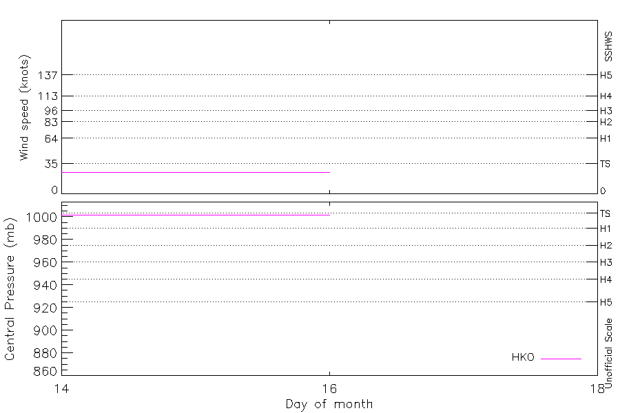
Summary Information
|
|
| Storm ID |
1961226N17141 |
| Start |
Aug 14 00Z |
| Max Intensity |
25 kt (Aug 14 03Z) |
| End |
Aug 16 00Z |
| ATCF IDs |
|
| Track status |
Best track data. |
|
Storm track plot

|
Intensity plots
|
Radial wind information
No radial wind information for this storm
|
Position and Intensity Table
| BASIN |
ISO_TIME_________ |
NATURE |
LAT |
LON |
HKO WIND |
HKO PRES |
| |
|
|
degrees north |
degrees east |
kts |
mb |
| WP |
1961-08-14 00:00:00 |
TS |
16.80 |
141.00 |
25 |
1002 |
| WP |
03:00:00 |
TS |
17.00 |
140.40 |
25 |
1002 |
| WP |
06:00:00 |
TS |
17.30 |
140.00 |
25 |
1002 |
| WP |
09:00:00 |
TS |
17.60 |
139.80 |
25 |
1002 |
| WP |
12:00:00 |
TS |
17.80 |
139.80 |
25 |
1002 |
| WP |
15:00:00 |
TS |
17.90 |
139.70 |
25 |
1002 |
| WP |
18:00:00 |
TS |
18.00 |
139.70 |
25 |
1002 |
| WP |
21:00:00 |
TS |
18.20 |
139.60 |
25 |
1002 |
| WP |
1961-08-15 00:00:00 |
TS |
18.50 |
139.60 |
25 |
1002 |
| WP |
03:00:00 |
TS |
18.80 |
139.60 |
25 |
1002 |
| WP |
06:00:00 |
TS |
19.00 |
139.70 |
25 |
1002 |
| WP |
09:00:00 |
TS |
19.10 |
139.70 |
25 |
1002 |
| WP |
12:00:00 |
TS |
19.30 |
139.70 |
25 |
1002 |
| WP |
15:00:00 |
TS |
19.60 |
139.70 |
25 |
1002 |
| WP |
18:00:00 |
TS |
19.80 |
139.80 |
25 |
1002 |
| WP |
21:00:00 |
TS |
19.90 |
139.90 |
25 |
1002 |
| WP |
1961-08-16 00:00:00 |
TS |
20.00 |
140.00 |
25 |
1002 |
Source Information
| Agency |
Information |
| USA |
|
| TOKYO |
|
| CMA |
|
| HKO |
tc-besttrack-data-current.txt:Line=357:TD0814A |
| KMA |
|
| NEWDELHI |
|
| REUNION |
|
| BOM |
|
| NADI |
|
| WELLINGTON |
|
| DS824 |
|
| TD9636 |
|
| TD9635 |
|
| NEUMANN |
|
| MLC |
|
All available IBTrACS Data
| SEASON |
BASIN |
SUBBASIN |
ISO_TIME_________ |
NATURE |
LAT |
LON |
DIST2LAND |
LANDFALL |
IFLAG |
USA SSHS |
HKO LAT |
HKO LON |
HKO CAT |
HKO WIND |
HKO PRES |
STORM SPEED |
STORM DIR |
| Year |
|
|
|
|
degrees north |
degrees east |
km |
km |
|
1 |
degrees north |
degrees east |
|
kts |
mb |
kts |
degrees |
| 1961 |
WP |
MM |
1961-08-14 00:00:00 |
TS |
16.80 |
141.00 |
1746 |
1701 |
___O___________ |
-5 |
16.80 |
141.00 |
TD |
25 |
1002 |
12 |
295 |
| 1961 |
WP |
MM |
03:00:00 |
TS |
17.00 |
140.40 |
1690 |
1660 |
___P___________ |
-5 |
17.00 |
140.40 |
TD |
25 |
1002 |
11 |
300 |
| 1961 |
WP |
MM |
06:00:00 |
TS |
17.30 |
140.00 |
1660 |
1647 |
___O___________ |
-5 |
17.30 |
140.00 |
TD |
25 |
1002 |
8 |
315 |
| 1961 |
WP |
MM |
09:00:00 |
TS |
17.60 |
139.80 |
1650 |
1650 |
___P___________ |
-5 |
17.60 |
139.80 |
TD |
25 |
1002 |
5 |
340 |
| 1961 |
WP |
MM |
12:00:00 |
TS |
17.80 |
139.80 |
1658 |
1652 |
___O___________ |
-5 |
17.80 |
139.80 |
TD |
25 |
1002 |
3 |
345 |
| 1961 |
WP |
MM |
15:00:00 |
TS |
17.90 |
139.70 |
1652 |
1652 |
___P___________ |
-5 |
17.90 |
139.70 |
TD |
25 |
1002 |
2 |
335 |
| 1961 |
WP |
MM |
18:00:00 |
TS |
18.00 |
139.70 |
1656 |
1654 |
___O___________ |
-5 |
18.00 |
139.70 |
TD |
25 |
1002 |
3 |
340 |
| 1961 |
WP |
MM |
21:00:00 |
TS |
18.20 |
139.60 |
1654 |
1654 |
___P___________ |
-5 |
18.20 |
139.60 |
TD |
25 |
1002 |
5 |
350 |
| 1961 |
WP |
MM |
1961-08-15 00:00:00 |
TS |
18.50 |
139.60 |
1658 |
1630 |
___O___________ |
-5 |
18.50 |
139.60 |
TD |
25 |
1002 |
5 |
5 |
| 1961 |
WP |
MM |
03:00:00 |
TS |
18.80 |
139.60 |
1630 |
1615 |
___P___________ |
-5 |
18.80 |
139.60 |
TD |
25 |
1002 |
5 |
10 |
| 1961 |
WP |
MM |
06:00:00 |
TS |
19.00 |
139.70 |
1615 |
1606 |
___O___________ |
-5 |
19.00 |
139.70 |
TD |
25 |
1002 |
4 |
10 |
| 1961 |
WP |
MM |
09:00:00 |
TS |
19.10 |
139.70 |
1596 |
1586 |
___P___________ |
-5 |
19.10 |
139.70 |
TD |
25 |
1002 |
3 |
0 |
| 1961 |
WP |
MM |
12:00:00 |
TS |
19.30 |
139.70 |
1586 |
1567 |
___O___________ |
-5 |
19.30 |
139.70 |
TD |
25 |
1002 |
4 |
5 |
| 1961 |
WP |
MM |
15:00:00 |
TS |
19.60 |
139.70 |
1557 |
1543 |
___P___________ |
-5 |
19.60 |
139.70 |
TD |
25 |
1002 |
5 |
10 |
| 1961 |
WP |
MM |
18:00:00 |
TS |
19.80 |
139.80 |
1543 |
1534 |
___O___________ |
-5 |
19.80 |
139.80 |
TD |
25 |
1002 |
4 |
20 |
| 1961 |
WP |
MM |
21:00:00 |
TS |
19.90 |
139.90 |
1539 |
1530 |
___P___________ |
-5 |
19.90 |
139.90 |
TD |
25 |
1002 |
3 |
45 |
| 1961 |
WP |
MM |
1961-08-16 00:00:00 |
TS |
20.00 |
140.00 |
1535 |
|
___O___________ |
-5 |
20.00 |
140.00 |
TD |
25 |
1002 |
2 |
60 |