1961
Tropical Depression UNNAMED (1961230N22131)
IBTrACS version v04r01. Visit
IBTrACS website for data access.
Please direct all questions to the
IBTrACS Q and A forum
Storm track
-
Intensity
-
Wind Radii
-
Intensity Data
-
Source Data
-
All data
Summary Information
|
|
| Storm ID |
1961230N22131 |
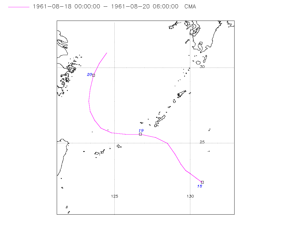
| Start |
Aug 18 00Z |
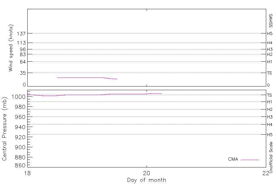
| Max Intensity |
23 kt (Aug 18 12Z) |
| End |
Aug 20 06Z |
| ATCF IDs |
|
| Track status |
Best track data. |
|
Storm track plot
|
Intensity plots
|
Radial wind information
No radial wind information for this storm
|
Position and Intensity Table
| BASIN |
ISO_TIME_________ |
NATURE |
LAT |
LON |
CMA WIND |
CMA PRES |
| |
|
|
degrees north |
degrees east |
kts |
mb |
| WP |
1961-08-18 00:00:00 |
DS |
22.40 |
130.80 |
|
1004 |
| WP |
03:00:00 |
DS |
22.70 |
130.40 |
|
1003 |
| WP |
06:00:00 |
DS |
23.00 |
130.00 |
|
1002 |
| WP |
09:00:00 |
DS |
23.20 |
129.70 |
|
1002 |
| WP |
12:00:00 |
TS |
23.60 |
129.40 |
23 |
1002 |
| WP |
15:00:00 |
TS |
24.30 |
129.00 |
23 |
1003 |
| WP |
18:00:00 |
TS |
25.00 |
128.50 |
23 |
1004 |
| WP |
21:00:00 |
TS |
25.40 |
127.70 |
23 |
1004 |
| WP |
1961-08-19 00:00:00 |
TS |
25.60 |
126.70 |
23 |
1004 |
| WP |
03:00:00 |
TS |
25.60 |
125.70 |
23 |
1004 |
| WP |
06:00:00 |
TS |
25.70 |
124.80 |
23 |
1004 |
| WP |
09:00:00 |
TS |
26.00 |
124.10 |
21 |
1005 |
| WP |
12:00:00 |
DS |
26.50 |
123.70 |
19 |
1006 |
| WP |
15:00:00 |
DS |
27.10 |
123.40 |
|
1006 |
| WP |
18:00:00 |
DS |
27.80 |
123.30 |
|
1006 |
| WP |
21:00:00 |
DS |
28.60 |
123.40 |
|
1006 |
| WP |
1961-08-20 00:00:00 |
DS |
29.50 |
123.60 |
|
1006 |
| WP |
03:00:00 |
DS |
30.30 |
124.00 |
|
1007 |
| WP |
06:00:00 |
DS |
31.00 |
124.50 |
|
1007 |
Source Information
| Agency |
Information |
| USA |
|
| TOKYO |
|
| CMA |
CH1961BST.txt:Storm=22:(nameless) |
| HKO |
|
| KMA |
|
| NEWDELHI |
|
| REUNION |
|
| BOM |
|
| NADI |
|
| WELLINGTON |
|
| DS824 |
|
| TD9636 |
|
| TD9635 |
|
| NEUMANN |
|
| MLC |
|
All available IBTrACS Data
| SEASON |
BASIN |
SUBBASIN |
ISO_TIME_________ |
NATURE |
LAT |
LON |
DIST2LAND |
LANDFALL |
IFLAG |
USA SSHS |
CMA LAT |
CMA LON |
CMA CAT |
CMA WIND |
CMA PRES |
STORM SPEED |
STORM DIR |
| Year |
|
|
|
|
degrees north |
degrees east |
km |
km |
|
1 |
degrees north |
degrees east |
1 |
kts |
mb |
kts |
degrees |
| 1961 |
WP |
MM |
1961-08-18 00:00:00 |
DS |
22.40 |
130.80 |
937 |
888 |
__O____________ |
-5 |
22.40 |
130.80 |
0 |
|
1004 |
10 |
310 |
| 1961 |
WP |
MM |
03:00:00 |
DS |
22.70 |
130.40 |
888 |
840 |
__P____________ |
-5 |
22.70 |
130.40 |
0 |
|
1003 |
10 |
310 |
| 1961 |
WP |
MM |
06:00:00 |
DS |
23.00 |
130.00 |
840 |
805 |
__O____________ |
-5 |
23.00 |
130.00 |
0 |
|
1002 |
8 |
310 |
| 1961 |
WP |
MM |
09:00:00 |
DS |
23.20 |
129.70 |
805 |
765 |
__P____________ |
-5 |
23.20 |
129.70 |
0 |
|
1002 |
8 |
315 |
| 1961 |
WP |
MM |
12:00:00 |
TS |
23.60 |
129.40 |
765 |
721 |
__O____________ |
-5 |
23.60 |
129.40 |
1 |
23 |
1002 |
12 |
330 |
| 1961 |
WP |
MM |
15:00:00 |
TS |
24.30 |
129.00 |
711 |
654 |
__P____________ |
-5 |
24.30 |
129.00 |
1 |
23 |
1003 |
16 |
330 |
| 1961 |
WP |
MM |
18:00:00 |
TS |
25.00 |
128.50 |
654 |
574 |
__O____________ |
-5 |
25.00 |
128.50 |
1 |
23 |
1004 |
17 |
310 |
| 1961 |
WP |
MM |
21:00:00 |
TS |
25.40 |
127.70 |
574 |
486 |
__P____________ |
-5 |
25.40 |
127.70 |
1 |
23 |
1004 |
17 |
290 |
| 1961 |
WP |
MM |
1961-08-19 00:00:00 |
TS |
25.60 |
126.70 |
476 |
377 |
__O____________ |
-5 |
25.60 |
126.70 |
1 |
23 |
1004 |
18 |
280 |
| 1961 |
WP |
MM |
03:00:00 |
TS |
25.60 |
125.70 |
377 |
291 |
__P____________ |
-5 |
25.60 |
125.70 |
1 |
23 |
1004 |
17 |
275 |
| 1961 |
WP |
MM |
06:00:00 |
TS |
25.70 |
124.80 |
291 |
242 |
__O____________ |
-5 |
25.70 |
124.80 |
1 |
23 |
1004 |
15 |
285 |
| 1961 |
WP |
MM |
09:00:00 |
TS |
26.00 |
124.10 |
238 |
231 |
__P____________ |
-5 |
26.00 |
124.10 |
1 |
21 |
1005 |
13 |
310 |
| 1961 |
WP |
MM |
12:00:00 |
DS |
26.50 |
123.70 |
238 |
228 |
__O____________ |
-5 |
26.50 |
123.70 |
0 |
19 |
1006 |
13 |
330 |
| 1961 |
WP |
MM |
15:00:00 |
DS |
27.10 |
123.40 |
222 |
175 |
__P____________ |
-5 |
27.10 |
123.40 |
0 |
|
1006 |
14 |
345 |
| 1961 |
WP |
MM |
18:00:00 |
DS |
27.80 |
123.30 |
175 |
143 |
__O____________ |
-5 |
27.80 |
123.30 |
0 |
|
1006 |
16 |
360 |
| 1961 |
WP |
MM |
21:00:00 |
DS |
28.60 |
123.40 |
151 |
136 |
__P____________ |
-5 |
28.60 |
123.40 |
0 |
|
1006 |
17 |
10 |
| 1961 |
WP |
MM |
1961-08-20 00:00:00 |
DS |
29.50 |
123.60 |
158 |
158 |
__O____________ |
-5 |
29.50 |
123.60 |
0 |
|
1006 |
17 |
20 |
| 1961 |
WP |
MM |
03:00:00 |
DS |
30.30 |
124.00 |
209 |
209 |
__P____________ |
-5 |
30.30 |
124.00 |
0 |
|
1007 |
17 |
25 |
| 1961 |
WP |
MM |
06:00:00 |
DS |
31.00 |
124.50 |
247 |
|
__O____________ |
-5 |
31.00 |
124.50 |
0 |
|
1007 |
17 |
30 |