1962
Tropical Cyclone (Gale) UNNAMED (1962048S17191)
IBTrACS version v04r01. Visit
IBTrACS website for data access.
Please direct all questions to the
IBTrACS Q and A forum
Storm track
-
Intensity
-
Wind Radii
-
Intensity Data
-
Source Data
-
All data
Summary Information
|
|
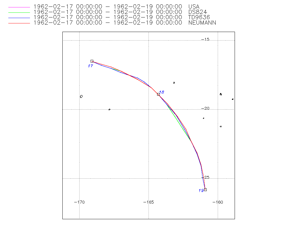
| Storm ID |
1962048S17191 |
| Start |
Feb 17 00Z |
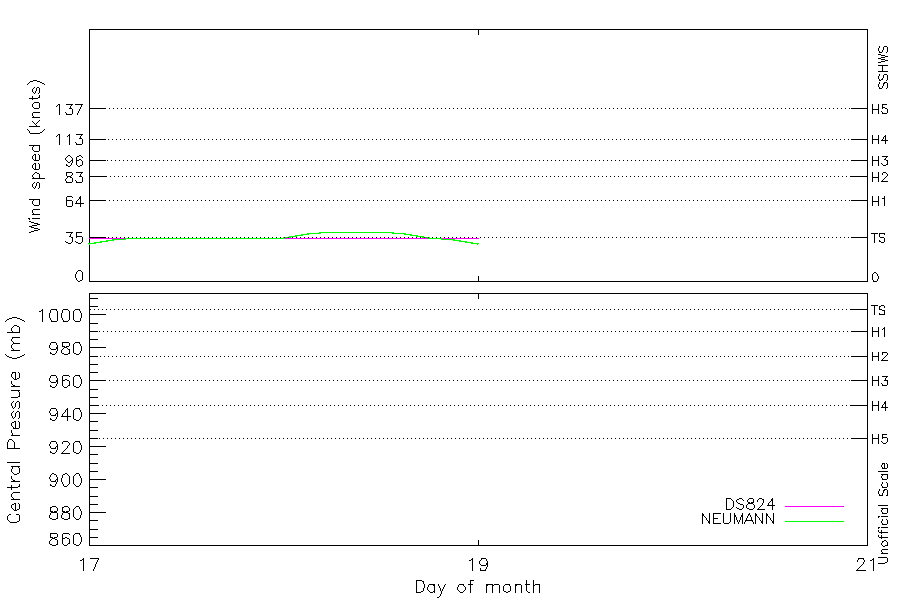
| Max Intensity |
40 kt (Feb 18 06Z) |
| End |
Feb 19 00Z |
| ATCF IDs |
SH181962 |
| Track status |
Best track data. |
|
Storm track plot
|
Intensity plots
|
Radial wind information
No radial wind information for this storm
|
Position and Intensity Table
| BASIN |
ISO_TIME_________ |
NATURE |
LAT |
LON |
DS824 WIND |
NEUMANN WIND |
| |
|
|
degrees north |
degrees east |
kts |
kts |
| SP |
1962-02-17 00:00:00 |
TS |
-16.50 |
-169.10 |
35 |
30 |
| SP |
03:00:00 |
TS |
-16.70 |
-168.40 |
35 |
33 |
| SP |
06:00:00 |
TS |
-17.00 |
-167.70 |
35 |
35 |
| SP |
09:00:00 |
TS |
-17.20 |
-167.00 |
35 |
35 |
| SP |
12:00:00 |
TS |
-17.50 |
-166.40 |
35 |
35 |
| SP |
15:00:00 |
TS |
-17.70 |
-165.80 |
35 |
35 |
| SP |
18:00:00 |
TS |
-18.00 |
-165.30 |
35 |
35 |
| SP |
21:00:00 |
TS |
-18.40 |
-164.80 |
35 |
35 |
| SP |
1962-02-18 00:00:00 |
TS |
-18.90 |
-164.30 |
35 |
35 |
| SP |
03:00:00 |
TS |
-19.60 |
-163.70 |
35 |
38 |
| SP |
06:00:00 |
TS |
-20.50 |
-163.00 |
35 |
40 |
| SP |
09:00:00 |
TS |
-21.40 |
-162.40 |
35 |
40 |
| SP |
12:00:00 |
TS |
-22.30 |
-161.90 |
35 |
40 |
| SP |
15:00:00 |
TS |
-23.20 |
-161.50 |
35 |
38 |
| SP |
18:00:00 |
TS |
-24.00 |
-161.20 |
35 |
35 |
| SP |
21:00:00 |
TS |
-24.90 |
-161.00 |
35 |
33 |
| SP |
1962-02-19 00:00:00 |
TS |
-25.80 |
-160.90 |
35 |
30 |
Source Information
| Agency |
Information |
| USA |
bsh181962.txt |
| TOKYO |
|
| CMA |
|
| HKO |
|
| KMA |
|
| NEWDELHI |
|
| REUNION |
|
| BOM |
|
| NADI |
|
| WELLINGTON |
|
| DS824 |
s_hem.dat:844:18P |
| TD9636 |
cons_worldwide_trop_cyclone_18710101-19891231-006:Line=6190 |
| TD9635 |
|
| NEUMANN |
tracks.sh:Storm=40:HSK1862:BSH1862:JTWC&NCDC |
| MLC |
|
All available IBTrACS Data
| SEASON |
BASIN |
SUBBASIN |
ISO_TIME_________ |
NATURE |
LAT |
LON |
DIST2LAND |
LANDFALL |
IFLAG |
USA AGENCY |
USA ATCF_ID |
USA LAT |
USA LON |
USA SSHS |
DS824 LAT |
DS824 LON |
DS824 STAGE |
DS824 WIND |
TD9636 LAT |
TD9636 LON |
TD9636 STAGE |
NEUMANN LAT |
NEUMANN LON |
NEUMANN CLASS |
NEUMANN WIND |
STORM SPEED |
STORM DIR |
| Year |
|
|
|
|
degrees north |
degrees east |
km |
km |
|
|
|
degrees north |
degrees east |
1 |
degrees north |
degrees east |
|
kts |
degrees north |
degrees east |
|
degrees north |
degrees east |
|
kts |
kts |
degrees |
| 1962 |
SP |
MM |
1962-02-17 00:00:00 |
TS |
-16.50 |
-169.10 |
449 |
449 |
O_________OO_O_ |
jtwc_sh |
SH181962 |
-16.50 |
-169.10 |
-5 |
-16.50 |
190.90 |
TC |
35 |
-16.50 |
-169.10 |
2 |
-16.50 |
-169.10 |
TC |
30 |
14 |
110 |
| 1962 |
SP |
MM |
03:00:00 |
TS |
-16.70 |
-168.40 |
521 |
521 |
P_________PP_P_ |
|
SH181962 |
-16.80 |
-168.40 |
-5 |
-16.80 |
-168.40 |
TC |
35 |
-16.80 |
-168.40 |
2 |
-16.70 |
-168.40 |
TC |
33 |
14 |
110 |
| 1962 |
SP |
MM |
06:00:00 |
TS |
-17.00 |
-167.70 |
600 |
600 |
O_________OP_O_ |
jtwc_sh |
SH181962 |
-17.00 |
-167.70 |
-5 |
-17.00 |
192.30 |
TC |
35 |
-17.00 |
-167.70 |
2 |
-16.90 |
-167.70 |
TC |
35 |
14 |
110 |
| 1962 |
SP |
MM |
09:00:00 |
TS |
-17.20 |
-167.00 |
674 |
674 |
P_________PP_P_ |
|
SH181962 |
-17.20 |
-167.00 |
-5 |
-17.20 |
-167.00 |
TC |
35 |
-17.30 |
-167.00 |
2 |
-17.20 |
-167.00 |
TC |
35 |
13 |
115 |
| 1962 |
SP |
MM |
12:00:00 |
TS |
-17.50 |
-166.40 |
746 |
746 |
O_________OO_O_ |
jtwc_sh |
SH181962 |
-17.50 |
-166.40 |
-5 |
-17.50 |
193.60 |
TC |
35 |
-17.50 |
-166.40 |
2 |
-17.50 |
-166.40 |
TC |
35 |
12 |
115 |
| 1962 |
SP |
MM |
15:00:00 |
TS |
-17.70 |
-165.80 |
812 |
812 |
P_________PP_P_ |
|
SH181962 |
-17.70 |
-165.80 |
-5 |
-17.70 |
-165.80 |
TC |
35 |
-17.70 |
-165.80 |
2 |
-17.80 |
-165.80 |
TC |
35 |
12 |
115 |
| 1962 |
SP |
MM |
18:00:00 |
TS |
-18.00 |
-165.30 |
874 |
874 |
O_________OP_O_ |
jtwc_sh |
SH181962 |
-18.00 |
-165.30 |
-5 |
-18.00 |
194.70 |
TC |
35 |
-18.00 |
-165.30 |
2 |
-18.10 |
-165.30 |
TC |
35 |
12 |
125 |
| 1962 |
SP |
MM |
21:00:00 |
TS |
-18.40 |
-164.80 |
943 |
943 |
P_________PP_P_ |
|
SH181962 |
-18.40 |
-164.80 |
-5 |
-18.40 |
-164.80 |
TC |
35 |
-18.40 |
-164.80 |
2 |
-18.40 |
-164.80 |
TC |
35 |
13 |
130 |
| 1962 |
SP |
MM |
1962-02-18 00:00:00 |
TS |
-18.90 |
-164.30 |
1017 |
1017 |
O_________OO_O_ |
jtwc_sh |
SH181962 |
-18.90 |
-164.30 |
-5 |
-18.90 |
195.70 |
TC |
35 |
-18.90 |
-164.30 |
2 |
-18.90 |
-164.30 |
TC |
35 |
16 |
140 |
| 1962 |
SP |
MM |
03:00:00 |
TS |
-19.60 |
-163.70 |
1113 |
1113 |
P_________PP_P_ |
|
SH181962 |
-19.60 |
-163.70 |
-5 |
-19.60 |
-163.70 |
TC |
35 |
-19.60 |
-163.70 |
2 |
-19.60 |
-163.60 |
TC |
38 |
20 |
145 |
| 1962 |
SP |
MM |
06:00:00 |
TS |
-20.50 |
-163.00 |
1231 |
1231 |
O_________OP_O_ |
jtwc_sh |
SH181962 |
-20.50 |
-163.10 |
-5 |
-20.50 |
196.90 |
TC |
35 |
-20.40 |
-163.00 |
2 |
-20.50 |
-162.90 |
TC |
40 |
21 |
145 |
| 1962 |
SP |
MM |
09:00:00 |
TS |
-21.40 |
-162.40 |
1341 |
1341 |
P_________PP_P_ |
|
SH181962 |
-21.40 |
-162.50 |
-5 |
-21.40 |
-162.50 |
TC |
35 |
-21.40 |
-162.40 |
2 |
-21.40 |
-162.30 |
TC |
40 |
21 |
150 |
| 1962 |
SP |
MM |
12:00:00 |
TS |
-22.30 |
-161.90 |
1444 |
1444 |
O_________OO_O_ |
jtwc_sh |
SH181962 |
-22.30 |
-161.90 |
-5 |
-22.30 |
198.10 |
TC |
35 |
-22.30 |
-161.90 |
2 |
-22.30 |
-161.90 |
TC |
40 |
20 |
155 |
| 1962 |
SP |
MM |
15:00:00 |
TS |
-23.20 |
-161.50 |
1541 |
1541 |
P_________PP_P_ |
|
SH181962 |
-23.10 |
-161.50 |
-5 |
-23.10 |
-161.50 |
TC |
35 |
-23.20 |
-161.50 |
2 |
-23.10 |
-161.50 |
TC |
38 |
18 |
160 |
| 1962 |
SP |
MM |
18:00:00 |
TS |
-24.00 |
-161.20 |
1623 |
1623 |
O_________OP_O_ |
jtwc_sh |
SH181962 |
-24.00 |
-161.20 |
-5 |
-24.00 |
198.80 |
TC |
35 |
-24.10 |
-161.20 |
2 |
-24.00 |
-161.20 |
TC |
35 |
18 |
165 |
| 1962 |
SP |
MM |
21:00:00 |
TS |
-24.90 |
-161.00 |
1707 |
1707 |
P_________PP_P_ |
|
SH181962 |
-24.90 |
-161.00 |
-5 |
-24.90 |
-161.00 |
TC |
35 |
-24.90 |
-161.10 |
2 |
-24.90 |
-161.00 |
TC |
33 |
18 |
170 |
| 1962 |
SP |
MM |
1962-02-19 00:00:00 |
TS |
-25.80 |
-160.90 |
1786 |
|
O_________OO_O_ |
jtwc_sh |
SH181962 |
-25.80 |
-160.90 |
-5 |
-25.80 |
199.10 |
TC |
35 |
-25.80 |
-160.90 |
2 |
-25.80 |
-160.90 |
TC |
30 |
18 |
175 |