1962
Moderate Tropical Storm ISABEL (1962053S26048)
IBTrACS version v04r01. Visit
IBTrACS website for data access.
Please direct all questions to the
IBTrACS Q and A forum
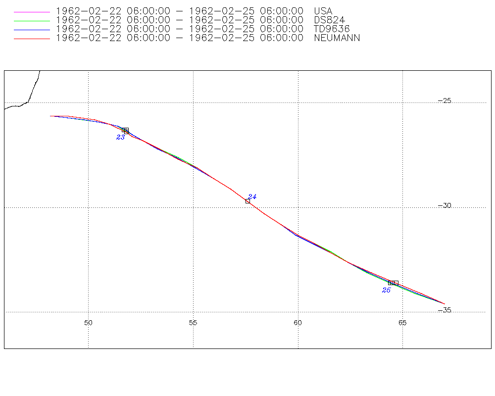
Storm track
-
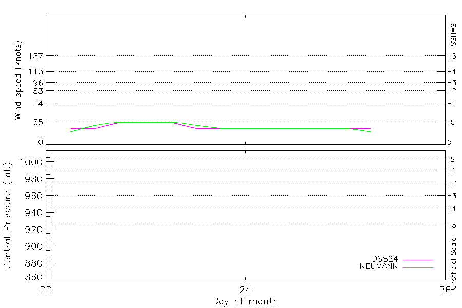
Intensity
-
Wind Radii
-
Intensity Data
-
Source Data
-
All data
Summary Information
|
|
| Storm ID |
1962053S26048 |
| Start |
Feb 22 06Z |
| Max Intensity |
35 kt (Feb 22 18Z) |
| End |
Feb 25 06Z |
| ATCF IDs |
SH201962 |
| Track status |
Best track data. |
|
Storm track plot
|
Intensity plots
|
Radial wind information
No radial wind information for this storm
|
Position and Intensity Table
| BASIN |
ISO_TIME_________ |
NATURE |
LAT |
LON |
DS824 WIND |
NEUMANN WIND |
| |
|
|
degrees north |
degrees east |
kts |
kts |
| SI |
1962-02-22 06:00:00 |
TS |
-25.60 |
48.20 |
25 |
20 |
| SI |
09:00:00 |
TS |
-25.70 |
48.90 |
25 |
25 |
| SI |
12:00:00 |
TS |
-25.80 |
49.70 |
25 |
30 |
| SI |
15:00:00 |
TS |
-25.90 |
50.40 |
30 |
33 |
| SI |
18:00:00 |
TS |
-26.00 |
51.00 |
35 |
35 |
| SI |
21:00:00 |
TS |
-26.10 |
51.40 |
35 |
35 |
| SI |
1962-02-23 00:00:00 |
TS |
-26.30 |
51.70 |
35 |
35 |
| SI |
03:00:00 |
TS |
-26.50 |
52.10 |
35 |
35 |
| SI |
06:00:00 |
TS |
-26.80 |
52.60 |
35 |
35 |
| SI |
09:00:00 |
TS |
-27.20 |
53.40 |
30 |
33 |
| SI |
12:00:00 |
TS |
-27.60 |
54.30 |
25 |
30 |
| SI |
15:00:00 |
TS |
-28.10 |
55.10 |
25 |
28 |
| SI |
18:00:00 |
TS |
-28.60 |
56.00 |
25 |
25 |
| SI |
21:00:00 |
TS |
-29.10 |
56.80 |
25 |
25 |
| SI |
1962-02-24 00:00:00 |
TS |
-29.70 |
57.60 |
25 |
25 |
| SI |
03:00:00 |
TS |
-30.30 |
58.40 |
25 |
25 |
| SI |
06:00:00 |
TS |
-30.80 |
59.20 |
25 |
25 |
| SI |
09:00:00 |
TS |
-31.30 |
60.00 |
25 |
25 |
| SI |
12:00:00 |
TS |
-31.70 |
60.80 |
25 |
25 |
| SI |
15:00:00 |
TS |
-32.10 |
61.50 |
25 |
25 |
| SI |
18:00:00 |
TS |
-32.60 |
62.40 |
25 |
25 |
| SI |
21:00:00 |
TS |
-33.10 |
63.40 |
25 |
25 |
| SI |
1962-02-25 00:00:00 |
TS |
-33.60 |
64.50 |
25 |
25 |
| SI |
03:00:00 |
TS |
-34.10 |
65.70 |
25 |
23 |
| SI |
06:00:00 |
TS |
-34.60 |
67.00 |
25 |
20 |
Source Information
| Agency |
Information |
| USA |
bsh201962.txt |
| TOKYO |
|
| CMA |
|
| HKO |
|
| KMA |
|
| NEWDELHI |
|
| REUNION |
|
| BOM |
|
| NADI |
|
| WELLINGTON |
|
| DS824 |
s_hem.dat:846:20S |
| TD9636 |
cons_worldwide_trop_cyclone_18710101-19891231-005:Line=8133 |
| TD9635 |
|
| NEUMANN |
tracks.sh:Storm=41:ISABEL:BSH2062:JTWC&NCDC |
| MLC |
|
All available IBTrACS Data
| SEASON |
BASIN |
SUBBASIN |
ISO_TIME_________ |
NATURE |
LAT |
LON |
DIST2LAND |
LANDFALL |
IFLAG |
USA AGENCY |
USA ATCF_ID |
USA LAT |
USA LON |
USA SSHS |
DS824 LAT |
DS824 LON |
DS824 STAGE |
DS824 WIND |
TD9636 LAT |
TD9636 LON |
TD9636 STAGE |
NEUMANN LAT |
NEUMANN LON |
NEUMANN CLASS |
NEUMANN WIND |
STORM SPEED |
STORM DIR |
| Year |
|
|
|
|
degrees north |
degrees east |
km |
km |
|
|
|
degrees north |
degrees east |
1 |
degrees north |
degrees east |
|
kts |
degrees north |
degrees east |
|
degrees north |
degrees east |
|
kts |
kts |
degrees |
| 1962 |
SI |
MM |
1962-02-22 06:00:00 |
TS |
-25.60 |
48.20 |
129 |
129 |
O_________OO_O_ |
jtwc_sh |
SH201962 |
-25.60 |
48.20 |
-5 |
-25.60 |
48.20 |
TC |
25 |
-25.60 |
48.20 |
7 |
-25.60 |
48.20 |
TC |
20 |
14 |
95 |
| 1962 |
SI |
MM |
09:00:00 |
TS |
-25.70 |
48.90 |
196 |
196 |
P_________PP_P_ |
|
SH201962 |
-25.70 |
49.00 |
-5 |
-25.70 |
49.00 |
TC |
25 |
-25.70 |
49.00 |
7 |
-25.60 |
48.90 |
TC |
25 |
14 |
95 |
| 1962 |
SI |
MM |
12:00:00 |
TS |
-25.80 |
49.70 |
275 |
275 |
O_________OP_O_ |
jtwc_sh |
SH201962 |
-25.80 |
49.70 |
-5 |
-25.80 |
49.70 |
TC |
25 |
-25.80 |
49.80 |
7 |
-25.70 |
49.60 |
TC |
30 |
13 |
100 |
| 1962 |
SI |
MM |
15:00:00 |
TS |
-25.90 |
50.40 |
346 |
346 |
P_________PP_P_ |
|
SH201962 |
-25.90 |
50.40 |
-5 |
-25.90 |
50.40 |
TC |
30 |
-25.90 |
50.40 |
7 |
-25.80 |
50.30 |
TC |
33 |
12 |
100 |
| 1962 |
SI |
MM |
18:00:00 |
TS |
-26.00 |
51.00 |
406 |
406 |
O_________OO_O_ |
jtwc_sh |
SH201962 |
-26.00 |
51.00 |
-5 |
-26.00 |
51.00 |
TC |
35 |
-26.00 |
51.00 |
2 |
-26.00 |
51.00 |
TC |
35 |
9 |
105 |
| 1962 |
SI |
MM |
21:00:00 |
TS |
-26.10 |
51.40 |
448 |
448 |
P_________PP_P_ |
|
SH201962 |
-26.10 |
51.40 |
-5 |
-26.10 |
51.40 |
TC |
35 |
-26.10 |
51.40 |
2 |
-26.20 |
51.40 |
TC |
35 |
7 |
115 |
| 1962 |
SI |
MM |
1962-02-23 00:00:00 |
TS |
-26.30 |
51.70 |
483 |
483 |
O_________OP_O_ |
jtwc_sh |
SH201962 |
-26.30 |
51.70 |
-5 |
-26.30 |
51.70 |
TC |
35 |
-26.30 |
51.80 |
2 |
-26.40 |
51.80 |
TC |
35 |
7 |
120 |
| 1962 |
SI |
MM |
03:00:00 |
TS |
-26.50 |
52.10 |
527 |
527 |
P_________PP_P_ |
|
SH201962 |
-26.50 |
52.10 |
-5 |
-26.50 |
52.10 |
TC |
35 |
-26.50 |
52.10 |
2 |
-26.60 |
52.10 |
TC |
35 |
9 |
120 |
| 1962 |
SI |
MM |
06:00:00 |
TS |
-26.80 |
52.60 |
585 |
585 |
O_________OO_O_ |
jtwc_sh |
SH201962 |
-26.80 |
52.60 |
-5 |
-26.80 |
52.60 |
TC |
35 |
-26.80 |
52.60 |
2 |
-26.80 |
52.60 |
TC |
35 |
13 |
120 |
| 1962 |
SI |
MM |
09:00:00 |
TS |
-27.20 |
53.40 |
674 |
674 |
P_________PP_P_ |
|
SH201962 |
-27.20 |
53.40 |
-5 |
-27.20 |
53.40 |
TC |
30 |
-27.20 |
53.30 |
2 |
-27.20 |
53.40 |
TC |
33 |
17 |
120 |
| 1962 |
SI |
MM |
12:00:00 |
TS |
-27.60 |
54.30 |
705 |
705 |
O_________OP_O_ |
jtwc_sh |
SH201962 |
-27.60 |
54.30 |
-5 |
-27.60 |
54.30 |
TC |
25 |
-27.60 |
54.20 |
2 |
-27.70 |
54.30 |
TC |
30 |
18 |
120 |
| 1962 |
SI |
MM |
15:00:00 |
TS |
-28.10 |
55.10 |
750 |
749 |
P_________PP_P_ |
|
SH201962 |
-28.10 |
55.20 |
-5 |
-28.10 |
55.20 |
TC |
25 |
-28.10 |
55.10 |
2 |
-28.10 |
55.20 |
TC |
28 |
18 |
125 |
| 1962 |
SI |
MM |
18:00:00 |
TS |
-28.60 |
56.00 |
805 |
805 |
O_________OO_O_ |
jtwc_sh |
SH201962 |
-28.60 |
56.00 |
-5 |
-28.60 |
56.00 |
TC |
25 |
-28.60 |
56.00 |
7 |
-28.60 |
56.00 |
TC |
25 |
18 |
125 |
| 1962 |
SI |
MM |
21:00:00 |
TS |
-29.10 |
56.80 |
868 |
868 |
P_________PP_P_ |
|
SH201962 |
-29.10 |
56.80 |
-5 |
-29.10 |
56.80 |
TC |
25 |
-29.10 |
56.80 |
7 |
-29.10 |
56.80 |
TC |
25 |
18 |
130 |
| 1962 |
SI |
MM |
1962-02-24 00:00:00 |
TS |
-29.70 |
57.60 |
948 |
948 |
O_________OP_O_ |
jtwc_sh |
SH201962 |
-29.70 |
57.60 |
-5 |
-29.70 |
57.60 |
TC |
25 |
-29.70 |
57.60 |
7 |
-29.70 |
57.60 |
TC |
25 |
18 |
130 |
| 1962 |
SI |
MM |
03:00:00 |
TS |
-30.30 |
58.40 |
1032 |
1032 |
P_________PP_P_ |
|
SH201962 |
-30.30 |
58.40 |
-5 |
-30.30 |
58.40 |
TC |
25 |
-30.30 |
58.40 |
7 |
-30.30 |
58.40 |
TC |
25 |
18 |
130 |
| 1962 |
SI |
MM |
06:00:00 |
TS |
-30.80 |
59.20 |
1109 |
1109 |
O_________OO_O_ |
jtwc_sh |
SH201962 |
-30.80 |
59.20 |
-5 |
-30.80 |
59.20 |
TC |
25 |
-30.80 |
59.20 |
7 |
-30.80 |
59.20 |
TC |
25 |
17 |
125 |
| 1962 |
SI |
MM |
09:00:00 |
TS |
-31.30 |
60.00 |
1189 |
1189 |
P_________PP_P_ |
|
SH201962 |
-31.30 |
60.00 |
-5 |
-31.30 |
60.00 |
TC |
25 |
-31.30 |
59.90 |
7 |
-31.30 |
60.00 |
TC |
25 |
16 |
125 |
| 1962 |
SI |
MM |
12:00:00 |
TS |
-31.70 |
60.80 |
1260 |
1260 |
O_________OP_O_ |
jtwc_sh |
SH201962 |
-31.70 |
60.80 |
-5 |
-31.70 |
60.80 |
TC |
25 |
-31.70 |
60.70 |
7 |
-31.70 |
60.80 |
TC |
25 |
16 |
125 |
| 1962 |
SI |
MM |
15:00:00 |
TS |
-32.10 |
61.50 |
1329 |
1329 |
P_________PP_P_ |
|
SH201962 |
-32.10 |
61.60 |
-5 |
-32.10 |
61.60 |
TC |
25 |
-32.10 |
61.50 |
7 |
-32.10 |
61.50 |
TC |
25 |
16 |
125 |
| 1962 |
SI |
MM |
18:00:00 |
TS |
-32.60 |
62.40 |
1419 |
1419 |
O_________OO_O_ |
jtwc_sh |
SH201962 |
-32.60 |
62.40 |
-5 |
-32.60 |
62.40 |
TC |
25 |
-32.60 |
62.40 |
7 |
-32.60 |
62.40 |
TC |
25 |
18 |
120 |
| 1962 |
SI |
MM |
21:00:00 |
TS |
-33.10 |
63.40 |
1515 |
1515 |
P_________PP_P_ |
|
SH201962 |
-33.10 |
63.30 |
-5 |
-33.10 |
63.30 |
TC |
25 |
-33.10 |
63.40 |
7 |
-33.10 |
63.50 |
TC |
25 |
20 |
120 |
| 1962 |
SI |
MM |
1962-02-25 00:00:00 |
TS |
-33.60 |
64.50 |
1609 |
1609 |
O_________OP_O_ |
jtwc_sh |
SH201962 |
-33.60 |
64.40 |
-5 |
-33.60 |
64.40 |
TC |
25 |
-33.60 |
64.50 |
7 |
-33.60 |
64.70 |
TC |
25 |
22 |
120 |
| 1962 |
SI |
MM |
03:00:00 |
TS |
-34.10 |
65.70 |
1656 |
1588 |
P_________PP_P_ |
|
SH201962 |
-34.10 |
65.60 |
-5 |
-34.10 |
65.60 |
TC |
25 |
-34.10 |
65.70 |
7 |
-34.10 |
65.90 |
TC |
23 |
23 |
115 |
| 1962 |
SI |
MM |
06:00:00 |
TS |
-34.60 |
67.00 |
1587 |
|
O_________OO_O_ |
jtwc_sh |
SH201962 |
-34.60 |
67.00 |
-5 |
-34.60 |
67.00 |
TC |
25 |
-34.60 |
67.00 |
7 |
-34.60 |
67.00 |
TC |
20 |
23 |
115 |