1962
Tropical Storm MARGE (1962209N13149)
IBTrACS version v04r01. Visit
IBTrACS website for data access.
Please direct all questions to the
IBTrACS Q and A forum
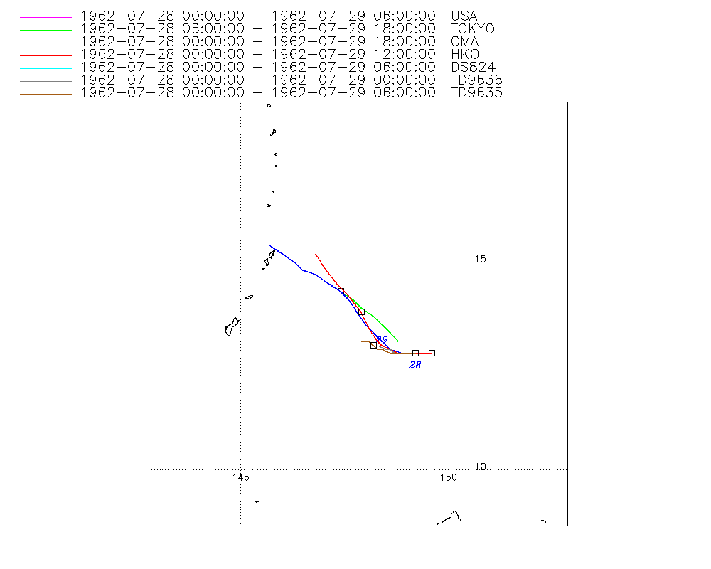
Storm track
-
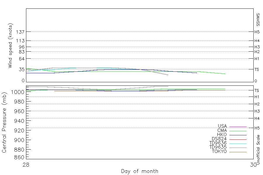
Intensity
-
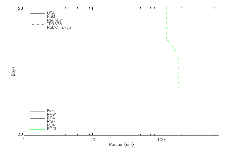
Wind Radii
-
Intensity Data
-
Source Data
-
All data
Summary Information
|
|
| Storm ID |
1962209N13149 |
| Start |
Jul 28 00Z |
| Max Intensity |
40 kt (Jul 28 06Z) |
| End |
Jul 29 18Z |
| ATCF IDs |
,WP091962 |
| Track status |
Best track data. |
|
Storm track plot
|
Intensity plots
|
Radial wind information
|
Position and Intensity Table
| BASIN |
ISO_TIME_________ |
NATURE |
LAT |
LON |
WMO PRES |
USA WIND |
TOKYO PRES |
CMA WIND |
CMA PRES |
HKO WIND |
HKO PRES |
DS824 WIND |
TD9636 WIND |
TD9635 WIND |
TD9635 PRES |
| |
|
|
degrees north |
degrees east |
mb |
kts |
mb |
kts |
mb |
kts |
mb |
kts |
kts |
kts |
mb |
| WP |
1962-07-28 00:00:00 |
TS |
12.80 |
149.30 |
|
30 |
|
38 |
1002 |
25 |
1005 |
30 |
30 |
30 |
1011 |
| WP |
03:00:00 |
TS |
12.80 |
149.10 |
|
35 |
|
34 |
1004 |
25 |
1005 |
35 |
33 |
35 |
1011 |
| WP |
06:00:00 |
TS |
12.80 |
148.90 |
1002 |
40 |
1002 |
29 |
1005 |
25 |
1005 |
40 |
35 |
40 |
1010 |
| WP |
09:00:00 |
TS |
12.90 |
148.70 |
|
40 |
1002 |
29 |
1005 |
28 |
1005 |
40 |
38 |
40 |
1009 |
| WP |
12:00:00 |
TS |
13.00 |
148.60 |
1002 |
40 |
1002 |
29 |
1005 |
30 |
1004 |
40 |
40 |
40 |
1007 |
| WP |
15:00:00 |
TS |
13.10 |
148.40 |
|
40 |
1002 |
29 |
1005 |
33 |
1003 |
40 |
39 |
40 |
1006 |
| WP |
18:00:00 |
TS |
13.20 |
148.20 |
1002 |
40 |
1002 |
29 |
1005 |
35 |
1002 |
40 |
38 |
40 |
1005 |
| WP |
21:00:00 |
TS |
13.40 |
148.10 |
|
38 |
1002 |
29 |
1005 |
35 |
1002 |
38 |
36 |
38 |
1007 |
| WP |
1962-07-29 00:00:00 |
TS |
13.60 |
147.90 |
1002 |
35 |
1002 |
29 |
1005 |
35 |
1002 |
35 |
35 |
35 |
1009 |
| WP |
03:00:00 |
TS |
13.90 |
147.50 |
|
28 |
1002 |
29 |
1006 |
33 |
1003 |
28 |
|
28 |
1011 |
| WP |
06:00:00 |
TS |
14.30 |
147.10 |
1002 |
20 |
1002 |
29 |
1007 |
30 |
1004 |
20 |
|
20 |
1012 |
| WP |
09:00:00 |
TS |
14.80 |
146.60 |
|
|
1003 |
29 |
1007 |
28 |
1005 |
|
|
|
|
| WP |
12:00:00 |
TS |
15.00 |
146.40 |
1004 |
|
1004 |
29 |
1007 |
25 |
1005 |
|
|
|
|
| WP |
15:00:00 |
TS |
15.20 |
146.00 |
|
|
1004 |
26 |
1007 |
|
|
|
|
|
|
| WP |
18:00:00 |
TS |
15.40 |
145.70 |
1004 |
|
1004 |
23 |
1007 |
|
|
|
|
|
|
Source Information
| Agency |
Information |
| USA |
bwp091962.txt |
| TOKYO |
bst_all.txt:Line=9854:MARGE:6208 |
| CMA |
CH1962BST.txt:Storm=11:Marge |
| HKO |
tc-besttrack-data-current.txt:Line=964:MARGE |
| KMA |
|
| NEWDELHI |
|
| REUNION |
|
| BOM |
|
| NADI |
|
| WELLINGTON |
|
| DS824 |
w_npac.dat:409:MARGE |
| TD9636 |
cons_worldwide_trop_cyclone_18710101-19891231-003:Line=19395 |
| TD9635 |
typhoons-analogs_19450101-19761231.corrected:Line=3926 |
| NEUMANN |
|
| MLC |
|
All available IBTrACS Data
| SEASON |
BASIN |
SUBBASIN |
ISO_TIME_________ |
NATURE |
LAT |
LON |
WMO PRES |
WMO AGENCY |
DIST2LAND |
LANDFALL |
IFLAG |
USA AGENCY |
USA ATCF_ID |
USA LAT |
USA LON |
USA WIND |
USA SSHS |
TOKYO LAT |
TOKYO LON |
TOKYO GRADE |
TOKYO PRES |
TOKYO R50_DIR |
TOKYO R30_DIR |
TOKYO LAND |
CMA LAT |
CMA LON |
CMA CAT |
CMA WIND |
CMA PRES |
HKO LAT |
HKO LON |
HKO CAT |
HKO WIND |
HKO PRES |
DS824 LAT |
DS824 LON |
DS824 STAGE |
DS824 WIND |
TD9636 LAT |
TD9636 LON |
TD9636 STAGE |
TD9636 WIND |
TD9635 LAT |
TD9635 LON |
TD9635 WIND |
TD9635 PRES |
TD9635 ROCI |
STORM SPEED |
STORM DIR |
| Year |
|
|
|
|
degrees north |
degrees east |
mb |
|
km |
km |
|
|
|
degrees north |
degrees east |
kts |
1 |
degrees north |
degrees east |
1 |
mb |
|
|
1 |
degrees north |
degrees east |
1 |
kts |
mb |
degrees north |
degrees east |
|
kts |
mb |
degrees north |
degrees east |
|
kts |
degrees north |
degrees east |
|
kts |
degrees north |
degrees east |
kts |
mb |
nmile |
kts |
degrees |
| 1962 |
WP |
MM |
1962-07-28 00:00:00 |
TS |
12.80 |
149.30 |
|
|
1682 |
1679 |
O_OO______OOO__ |
jtwc_wp |
WP091962 |
12.80 |
149.20 |
30 |
-1 |
|
|
|
|
|
|
|
12.80 |
149.20 |
2 |
38 |
1002 |
12.80 |
149.60 |
TD |
25 |
1005 |
12.80 |
149.20 |
TC |
30 |
12.80 |
149.20 |
1 |
30 |
12.80 |
149.20 |
30 |
1011 |
120 |
4 |
270 |
| 1962 |
WP |
MM |
03:00:00 |
TS |
12.80 |
149.10 |
|
|
1679 |
1677 |
P_PP______PPP__ |
|
WP091962 |
12.80 |
149.00 |
35 |
0 |
|
|
|
|
|
|
|
12.80 |
148.90 |
2 |
34 |
1004 |
12.80 |
149.30 |
TD |
25 |
1005 |
12.80 |
149.00 |
TC |
35 |
12.80 |
149.10 |
1 |
33 |
12.80 |
149.00 |
35 |
1011 |
120 |
4 |
275 |
| 1962 |
WP |
MM |
06:00:00 |
TS |
12.80 |
148.90 |
1002 |
tokyo |
1677 |
1676 |
OOOO______OPO__ |
jtwc_wp |
WP091962 |
12.80 |
148.90 |
40 |
0 |
13.10 |
148.80 |
9 |
1002 |
0 |
0 |
0 |
12.90 |
148.60 |
1 |
29 |
1005 |
12.80 |
149.00 |
TD |
25 |
1005 |
12.80 |
148.90 |
TC |
40 |
12.80 |
149.00 |
1 |
35 |
12.80 |
148.90 |
40 |
1010 |
120 |
3 |
285 |
| 1962 |
WP |
MM |
09:00:00 |
TS |
12.90 |
148.70 |
|
|
1686 |
1685 |
PPPP______PPP__ |
|
WP091962 |
12.80 |
148.80 |
40 |
0 |
13.30 |
148.60 |
9 |
1002 |
0 |
0 |
|
13.10 |
148.40 |
1 |
29 |
1005 |
12.80 |
148.80 |
TD |
28 |
1005 |
12.80 |
148.80 |
TC |
40 |
12.80 |
148.80 |
1 |
38 |
12.80 |
148.80 |
40 |
1009 |
120 |
3 |
295 |
| 1962 |
WP |
MM |
12:00:00 |
TS |
13.00 |
148.60 |
1002 |
tokyo |
1696 |
1696 |
OOOO______OOO__ |
jtwc_wp |
WP091962 |
12.80 |
148.70 |
40 |
0 |
13.50 |
148.40 |
9 |
1002 |
0 |
0 |
0 |
13.30 |
148.20 |
1 |
29 |
1005 |
12.90 |
148.60 |
TD |
30 |
1004 |
12.80 |
148.70 |
TC |
40 |
12.80 |
148.70 |
2 |
40 |
12.80 |
148.70 |
40 |
1007 |
120 |
4 |
305 |
| 1962 |
WP |
MM |
15:00:00 |
TS |
13.10 |
148.40 |
|
|
1706 |
1705 |
PPPP______PPP__ |
|
WP091962 |
12.80 |
148.60 |
40 |
0 |
13.70 |
148.20 |
9 |
1002 |
0 |
0 |
|
13.50 |
148.00 |
1 |
29 |
1005 |
13.00 |
148.40 |
TD |
33 |
1003 |
12.80 |
148.60 |
TC |
40 |
12.90 |
148.60 |
2 |
39 |
12.80 |
148.60 |
40 |
1006 |
150 |
4 |
305 |
| 1962 |
WP |
MM |
18:00:00 |
TS |
13.20 |
148.20 |
1002 |
tokyo |
1716 |
1716 |
OOOO______OPO__ |
jtwc_wp |
WP091962 |
12.90 |
148.40 |
40 |
0 |
13.90 |
147.90 |
9 |
1002 |
0 |
0 |
0 |
13.80 |
147.80 |
1 |
29 |
1005 |
13.10 |
148.30 |
TS |
35 |
1002 |
12.90 |
148.40 |
TC |
40 |
12.90 |
148.50 |
2 |
38 |
12.90 |
148.40 |
40 |
1005 |
180 |
4 |
310 |
| 1962 |
WP |
MM |
21:00:00 |
TS |
13.40 |
148.10 |
|
|
1738 |
1737 |
PPPP______PPP__ |
|
WP091962 |
12.90 |
148.30 |
38 |
0 |
14.10 |
147.70 |
9 |
1002 |
0 |
0 |
|
14.10 |
147.60 |
1 |
29 |
1005 |
13.40 |
148.10 |
TS |
35 |
1002 |
12.90 |
148.30 |
TC |
38 |
13.00 |
148.30 |
2 |
36 |
12.90 |
148.30 |
38 |
1007 |
180 |
5 |
320 |
| 1962 |
WP |
MM |
1962-07-29 00:00:00 |
TS |
13.60 |
147.90 |
1002 |
tokyo |
1759 |
1759 |
OOOO______OOO__ |
jtwc_wp |
WP091962 |
13.00 |
148.20 |
35 |
0 |
14.30 |
147.40 |
9 |
1002 |
0 |
0 |
0 |
14.30 |
147.40 |
1 |
29 |
1005 |
13.80 |
147.90 |
TS |
35 |
1002 |
13.00 |
148.20 |
TC |
35 |
13.00 |
148.20 |
2 |
35 |
13.00 |
148.20 |
35 |
1009 |
180 |
8 |
320 |
| 1962 |
WP |
MM |
03:00:00 |
TS |
13.90 |
147.50 |
|
|
1792 |
1792 |
PPPP______P_P__ |
|
WP091962 |
13.10 |
148.10 |
28 |
-1 |
14.50 |
147.10 |
9 |
1002 |
0 |
0 |
|
14.50 |
147.10 |
1 |
29 |
1006 |
14.20 |
147.60 |
TS |
33 |
1003 |
13.10 |
148.10 |
TC |
28 |
|
|
|
|
13.10 |
148.10 |
28 |
1011 |
180 |
10 |
315 |
| 1962 |
WP |
MM |
06:00:00 |
TS |
14.30 |
147.10 |
1002 |
tokyo |
1837 |
1837 |
OOOO______O_O__ |
jtwc_wp |
WP091962 |
13.10 |
147.90 |
20 |
-1 |
14.70 |
146.80 |
2 |
1002 |
0 |
0 |
0 |
14.70 |
146.80 |
1 |
29 |
1007 |
14.50 |
147.30 |
TD |
30 |
1004 |
13.10 |
147.90 |
TC |
20 |
|
|
|
|
13.10 |
147.90 |
20 |
1012 |
180 |
13 |
315 |
| 1962 |
WP |
MM |
09:00:00 |
TS |
14.80 |
146.60 |
|
|
1893 |
1893 |
_PPP___________ |
|
WP091962 |
|
|
|
-5 |
14.80 |
146.50 |
2 |
1003 |
0 |
0 |
|
14.80 |
146.50 |
1 |
29 |
1007 |
14.90 |
147.00 |
TD |
28 |
1005 |
|
|
|
|
|
|
|
|
|
|
|
|
|
10 |
315 |
| 1962 |
WP |
MM |
12:00:00 |
TS |
15.00 |
146.40 |
1004 |
tokyo |
1915 |
1915 |
_OOO___________ |
|
|
|
|
|
-5 |
15.00 |
146.30 |
2 |
1004 |
0 |
0 |
0 |
15.00 |
146.30 |
1 |
29 |
1007 |
15.20 |
146.80 |
TD |
25 |
1005 |
|
|
|
|
|
|
|
|
|
|
|
|
|
7 |
300 |
| 1962 |
WP |
MM |
15:00:00 |
TS |
15.20 |
146.00 |
|
|
1939 |
1939 |
_PP____________ |
|
|
|
|
|
-5 |
15.20 |
146.00 |
2 |
1004 |
0 |
0 |
|
15.20 |
146.00 |
1 |
26 |
1007 |
|
|
|
|
|
|
|
|
|
|
|
|
|
|
|
|
|
|
7 |
300 |
| 1962 |
WP |
MM |
18:00:00 |
TS |
15.40 |
145.70 |
1004 |
tokyo |
1962 |
|
_OO____________ |
|
|
|
|
|
-5 |
15.40 |
145.70 |
2 |
1004 |
0 |
0 |
0 |
15.40 |
145.70 |
1 |
23 |
1007 |
|
|
|
|
|
|
|
|
|
|
|
|
|
|
|
|
|
|
7 |
305 |