1962
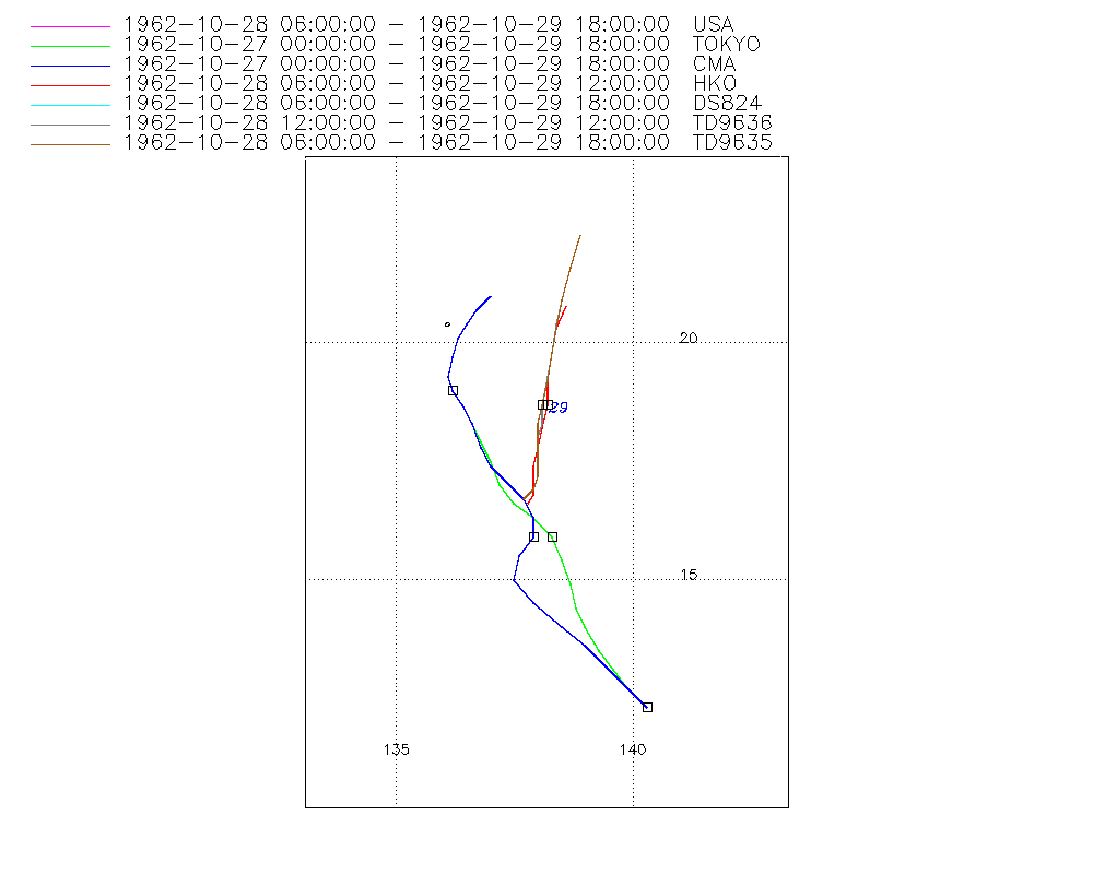
Typhoon IVY (1962300N12140)
IBTrACS version v04r01. Visit
IBTrACS website for data access.
Please direct all questions to the
IBTrACS Q and A forum
Storm track
-
Intensity
-
Wind Radii
-
Intensity Data
-
Source Data
-
All data
Summary Information
|
|
| Storm ID |
1962300N12140 |
| Start |
Oct 27 00Z |
| Max Intensity |
100 kt (Oct 28 06Z), 945 mb (Oct 28 06Z) |
| End |
Oct 29 18Z |
| ATCF IDs |
,WP251962 |
| Track status |
Best track data. |
|
Storm track plot
|
Intensity plots
|
Radial wind information

|
Position and Intensity Table
| BASIN |
ISO_TIME_________ |
NATURE |
LAT |
LON |
WMO PRES |
USA WIND |
TOKYO PRES |
CMA WIND |
CMA PRES |
HKO WIND |
HKO PRES |
DS824 WIND |
TD9636 WIND |
TD9635 WIND |
TD9635 PRES |
| |
|
|
degrees north |
degrees east |
mb |
kts |
mb |
kts |
mb |
kts |
mb |
kts |
kts |
kts |
mb |
| WP |
1962-10-27 00:00:00 |
MX |
12.30 |
140.30 |
1010 |
|
1010 |
|
1010 |
|
|
|
|
|
|
| WP |
03:00:00 |
MX |
12.70 |
139.90 |
|
|
1009 |
|
1009 |
|
|
|
|
|
|
| WP |
06:00:00 |
MX |
13.20 |
139.50 |
1008 |
|
1008 |
|
1008 |
|
|
|
|
|
|
| WP |
09:00:00 |
MX |
13.60 |
139.10 |
|
|
1008 |
|
1007 |
|
|
|
|
|
|
| WP |
12:00:00 |
TS |
14.00 |
138.80 |
1008 |
|
1008 |
29 |
1006 |
|
|
|
|
|
|
| WP |
15:00:00 |
TS |
14.50 |
138.40 |
|
|
1007 |
34 |
1004 |
|
|
|
|
|
|
| WP |
18:00:00 |
TS |
15.00 |
138.10 |
1006 |
|
1006 |
38 |
1002 |
|
|
|
|
|
|
| WP |
21:00:00 |
TS |
15.40 |
138.10 |
|
|
1003 |
48 |
1000 |
|
|
|
|
|
|
| WP |
1962-10-28 00:00:00 |
TS |
15.90 |
138.10 |
1000 |
|
1000 |
58 |
998 |
|
|
|
|
|
|
| WP |
03:00:00 |
TS |
16.30 |
137.90 |
|
|
998 |
68 |
994 |
|
|
|
|
|
|
| WP |
06:00:00 |
TS |
16.70 |
137.60 |
996 |
100 |
996 |
77 |
990 |
90 |
945 |
100 |
|
100 |
997 |
| WP |
09:00:00 |
TS |
17.00 |
137.60 |
|
100 |
996 |
77 |
990 |
90 |
945 |
100 |
|
100 |
994 |
| WP |
12:00:00 |
TS |
17.30 |
137.60 |
996 |
100 |
996 |
77 |
990 |
90 |
945 |
100 |
100 |
100 |
990 |
| WP |
15:00:00 |
TS |
17.60 |
137.60 |
|
100 |
997 |
73 |
993 |
85 |
950 |
100 |
95 |
100 |
990 |
| WP |
18:00:00 |
TS |
18.00 |
137.60 |
998 |
100 |
998 |
68 |
995 |
80 |
955 |
100 |
90 |
100 |
990 |
| WP |
21:00:00 |
TS |
18.40 |
137.60 |
|
90 |
999 |
58 |
998 |
70 |
965 |
90 |
85 |
90 |
991 |
| WP |
1962-10-29 00:00:00 |
TS |
18.80 |
137.60 |
1000 |
80 |
1000 |
48 |
1000 |
60 |
975 |
80 |
80 |
80 |
992 |
| WP |
03:00:00 |
TS |
19.30 |
137.60 |
|
70 |
1000 |
43 |
1000 |
53 |
982 |
70 |
71 |
70 |
993 |
| WP |
06:00:00 |
TS |
19.80 |
137.70 |
1000 |
60 |
1000 |
38 |
1000 |
45 |
988 |
60 |
61 |
60 |
994 |
| WP |
09:00:00 |
TS |
20.20 |
137.70 |
|
50 |
1001 |
34 |
1003 |
38 |
993 |
50 |
52 |
51 |
996 |
| WP |
12:00:00 |
TS |
20.70 |
137.80 |
1002 |
40 |
1002 |
29 |
1005 |
30 |
997 |
40 |
42 |
42 |
998 |
| WP |
15:00:00 |
TS |
21.20 |
137.90 |
|
38 |
1002 |
29 |
1006 |
|
|
38 |
|
39 |
1000 |
| WP |
18:00:00 |
TS |
21.80 |
138.10 |
1002 |
35 |
1002 |
29 |
1006 |
|
|
35 |
|
35 |
1002 |
Source Information
| Agency |
Information |
| USA |
bwp251962.txt |
| TOKYO |
bst_all.txt:Line=10573:IVY:6226 |
| CMA |
CH1962BST.txt:Storm=32:Ivy |
| HKO |
tc-besttrack-data-current.txt:Line=1455:IVY |
| KMA |
|
| NEWDELHI |
|
| REUNION |
|
| BOM |
|
| NADI |
|
| WELLINGTON |
|
| DS824 |
w_npac.dat:430:UNKNOWN |
| TD9636 |
cons_worldwide_trop_cyclone_18710101-19891231-003:Line=19627 |
| TD9635 |
typhoons-analogs_19450101-19761231.corrected:Line=11810 |
| NEUMANN |
|
| MLC |
|
All available IBTrACS Data
| SEASON |
BASIN |
SUBBASIN |
ISO_TIME_________ |
NATURE |
LAT |
LON |
WMO PRES |
WMO AGENCY |
DIST2LAND |
LANDFALL |
IFLAG |
USA AGENCY |
USA ATCF_ID |
USA LAT |
USA LON |
USA WIND |
USA SSHS |
TOKYO LAT |
TOKYO LON |
TOKYO GRADE |
TOKYO PRES |
TOKYO R50_DIR |
TOKYO R30_DIR |
TOKYO LAND |
CMA LAT |
CMA LON |
CMA CAT |
CMA WIND |
CMA PRES |
HKO LAT |
HKO LON |
HKO CAT |
HKO WIND |
HKO PRES |
DS824 LAT |
DS824 LON |
DS824 STAGE |
DS824 WIND |
TD9636 LAT |
TD9636 LON |
TD9636 STAGE |
TD9636 WIND |
TD9635 LAT |
TD9635 LON |
TD9635 WIND |
TD9635 PRES |
TD9635 ROCI |
STORM SPEED |
STORM DIR |
| Year |
|
|
|
|
degrees north |
degrees east |
mb |
|
km |
km |
|
|
|
degrees north |
degrees east |
kts |
1 |
degrees north |
degrees east |
1 |
mb |
|
|
1 |
degrees north |
degrees east |
1 |
kts |
mb |
degrees north |
degrees east |
|
kts |
mb |
degrees north |
degrees east |
|
kts |
degrees north |
degrees east |
|
kts |
degrees north |
degrees east |
kts |
mb |
nmile |
kts |
degrees |
| 1962 |
WP |
MM |
1962-10-27 00:00:00 |
MX |
12.30 |
140.30 |
1010 |
tokyo |
1546 |
1546 |
_OO____________ |
|
|
|
|
|
-5 |
12.30 |
140.30 |
2 |
1010 |
0 |
0 |
0 |
12.30 |
140.30 |
0 |
|
1010 |
|
|
|
|
|
|
|
|
|
|
|
|
|
|
|
|
|
|
12 |
315 |
| 1962 |
WP |
MM |
03:00:00 |
MX |
12.70 |
139.90 |
|
|
1546 |
1509 |
_PP____________ |
|
|
|
|
|
-5 |
12.70 |
139.90 |
2 |
1009 |
0 |
0 |
|
12.80 |
139.80 |
0 |
|
1009 |
|
|
|
|
|
|
|
|
|
|
|
|
|
|
|
|
|
|
12 |
315 |
| 1962 |
WP |
MM |
06:00:00 |
MX |
13.20 |
139.50 |
1008 |
tokyo |
1510 |
1472 |
_OO____________ |
|
|
|
|
|
-5 |
13.10 |
139.60 |
2 |
1008 |
0 |
0 |
0 |
13.20 |
139.40 |
0 |
|
1008 |
|
|
|
|
|
|
|
|
|
|
|
|
|
|
|
|
|
|
11 |
320 |
| 1962 |
WP |
MM |
09:00:00 |
MX |
13.60 |
139.10 |
|
|
1474 |
1448 |
_PP____________ |
|
|
|
|
|
-5 |
13.50 |
139.30 |
2 |
1008 |
0 |
0 |
|
13.60 |
139.00 |
0 |
|
1007 |
|
|
|
|
|
|
|
|
|
|
|
|
|
|
|
|
|
|
11 |
320 |
| 1962 |
WP |
MM |
12:00:00 |
TS |
14.00 |
138.80 |
1008 |
tokyo |
1451 |
1418 |
_OO____________ |
|
|
|
|
|
-5 |
14.00 |
139.00 |
2 |
1008 |
0 |
0 |
0 |
14.00 |
138.50 |
1 |
29 |
1006 |
|
|
|
|
|
|
|
|
|
|
|
|
|
|
|
|
|
|
12 |
320 |
| 1962 |
WP |
MM |
15:00:00 |
TS |
14.50 |
138.40 |
|
|
1419 |
1393 |
_PP____________ |
|
|
|
|
|
-5 |
14.40 |
138.80 |
2 |
1007 |
0 |
0 |
|
14.50 |
137.90 |
1 |
34 |
1004 |
|
|
|
|
|
|
|
|
|
|
|
|
|
|
|
|
|
|
11 |
325 |
| 1962 |
WP |
MM |
18:00:00 |
TS |
15.00 |
138.10 |
1006 |
tokyo |
1397 |
1397 |
_OO____________ |
|
|
|
|
|
-5 |
14.90 |
138.70 |
2 |
1006 |
0 |
0 |
0 |
15.00 |
137.50 |
2 |
38 |
1002 |
|
|
|
|
|
|
|
|
|
|
|
|
|
|
|
|
|
|
10 |
345 |
| 1962 |
WP |
MM |
21:00:00 |
TS |
15.40 |
138.10 |
|
|
1407 |
1407 |
_PP____________ |
|
|
|
|
|
-5 |
15.40 |
138.50 |
2 |
1003 |
0 |
0 |
|
15.50 |
137.60 |
2 |
48 |
1000 |
|
|
|
|
|
|
|
|
|
|
|
|
|
|
|
|
|
|
10 |
0 |
| 1962 |
WP |
MM |
1962-10-28 00:00:00 |
TS |
15.90 |
138.10 |
1000 |
tokyo |
1421 |
1409 |
_OO____________ |
|
|
|
|
|
-5 |
15.90 |
138.30 |
9 |
1000 |
0 |
0 |
0 |
15.90 |
137.90 |
3 |
58 |
998 |
|
|
|
|
|
|
|
|
|
|
|
|
|
|
|
|
|
|
9 |
350 |
| 1962 |
WP |
MM |
03:00:00 |
TS |
16.30 |
137.90 |
|
|
1413 |
1399 |
_PP____________ |
|
|
|
|
|
-5 |
16.30 |
137.90 |
9 |
998 |
0 |
0 |
|
16.30 |
137.90 |
3 |
68 |
994 |
|
|
|
|
|
|
|
|
|
|
|
|
|
|
|
|
|
|
9 |
330 |
| 1962 |
WP |
MM |
06:00:00 |
TS |
16.70 |
137.60 |
996 |
tokyo |
1396 |
1396 |
OOOO______O_O__ |
jtwc_wp |
WP251962 |
16.70 |
137.70 |
100 |
3 |
16.60 |
137.50 |
9 |
996 |
0 |
0 |
0 |
16.70 |
137.70 |
4 |
77 |
990 |
16.60 |
137.80 |
ST |
90 |
945 |
16.70 |
137.70 |
TC |
100 |
|
|
|
|
16.70 |
137.70 |
100 |
997 |
120 |
8 |
335 |
| 1962 |
WP |
MM |
09:00:00 |
TS |
17.00 |
137.60 |
|
|
1408 |
1408 |
PPPP______P_P__ |
|
WP251962 |
16.90 |
137.90 |
100 |
3 |
17.00 |
137.20 |
9 |
996 |
0 |
0 |
|
17.00 |
137.40 |
4 |
77 |
990 |
16.80 |
137.90 |
ST |
90 |
945 |
16.90 |
137.90 |
TC |
100 |
|
|
|
|
16.90 |
137.90 |
100 |
994 |
120 |
6 |
355 |
| 1962 |
WP |
MM |
12:00:00 |
TS |
17.30 |
137.60 |
996 |
tokyo |
1420 |
1420 |
OOOO______OOO__ |
jtwc_wp |
WP251962 |
17.20 |
138.00 |
100 |
3 |
17.50 |
137.00 |
9 |
996 |
0 |
0 |
0 |
17.40 |
137.00 |
4 |
77 |
990 |
17.10 |
137.90 |
ST |
90 |
945 |
17.20 |
138.00 |
TC |
100 |
17.20 |
138.00 |
3 |
100 |
17.20 |
138.00 |
100 |
990 |
120 |
7 |
5 |
| 1962 |
WP |
MM |
15:00:00 |
TS |
17.60 |
137.60 |
|
|
1433 |
1433 |
PPPP______PPP__ |
|
WP251962 |
17.50 |
138.00 |
100 |
3 |
17.90 |
136.80 |
9 |
997 |
0 |
0 |
|
17.80 |
136.80 |
4 |
73 |
993 |
17.40 |
137.90 |
ST |
85 |
950 |
17.50 |
138.00 |
TC |
100 |
17.60 |
138.00 |
3 |
95 |
17.50 |
138.00 |
100 |
990 |
120 |
7 |
360 |
| 1962 |
WP |
MM |
18:00:00 |
TS |
18.00 |
137.60 |
998 |
tokyo |
1451 |
1451 |
OOOO______OPO__ |
jtwc_wp |
WP251962 |
17.90 |
138.00 |
100 |
3 |
18.30 |
136.60 |
9 |
998 |
0 |
0 |
0 |
18.30 |
136.60 |
4 |
68 |
995 |
17.80 |
138.00 |
T |
80 |
955 |
17.90 |
138.00 |
TC |
100 |
18.00 |
138.00 |
3 |
90 |
17.90 |
138.00 |
100 |
990 |
120 |
8 |
355 |
| 1962 |
WP |
MM |
21:00:00 |
TS |
18.40 |
137.60 |
|
|
1471 |
1471 |
PPPP______PPP__ |
|
WP251962 |
18.30 |
138.00 |
90 |
2 |
18.70 |
136.40 |
9 |
999 |
0 |
0 |
|
18.70 |
136.40 |
4 |
58 |
998 |
18.20 |
138.10 |
T |
70 |
965 |
18.30 |
138.00 |
TC |
90 |
18.30 |
138.10 |
3 |
85 |
18.30 |
138.00 |
90 |
991 |
120 |
8 |
0 |
| 1962 |
WP |
MM |
1962-10-29 00:00:00 |
TS |
18.80 |
137.60 |
1000 |
tokyo |
1491 |
1488 |
OOOO______OOO__ |
jtwc_wp |
WP251962 |
18.70 |
138.10 |
80 |
1 |
19.00 |
136.20 |
9 |
1000 |
0 |
0 |
0 |
19.00 |
136.20 |
3 |
48 |
1000 |
18.70 |
138.20 |
STS |
60 |
975 |
18.70 |
138.10 |
TC |
80 |
18.70 |
138.10 |
4 |
80 |
18.70 |
138.10 |
80 |
992 |
120 |
9 |
5 |
| 1962 |
WP |
MM |
03:00:00 |
TS |
19.30 |
137.60 |
|
|
1478 |
1439 |
PPPP______PPP__ |
|
WP251962 |
19.20 |
138.20 |
70 |
1 |
19.30 |
136.10 |
9 |
1000 |
0 |
0 |
|
19.30 |
136.10 |
3 |
43 |
1000 |
19.20 |
138.20 |
STS |
53 |
982 |
19.20 |
138.20 |
TC |
70 |
19.30 |
138.20 |
4 |
71 |
19.20 |
138.20 |
70 |
993 |
120 |
10 |
5 |
| 1962 |
WP |
MM |
06:00:00 |
TS |
19.80 |
137.70 |
1000 |
tokyo |
1434 |
1394 |
OOOO______OPO__ |
jtwc_wp |
WP251962 |
19.80 |
138.30 |
60 |
0 |
19.70 |
136.20 |
2 |
1000 |
0 |
0 |
0 |
19.70 |
136.20 |
2 |
38 |
1000 |
19.80 |
138.30 |
TS |
45 |
988 |
19.80 |
138.30 |
TC |
60 |
19.80 |
138.30 |
4 |
61 |
19.80 |
138.30 |
60 |
994 |
120 |
10 |
5 |
| 1962 |
WP |
MM |
09:00:00 |
TS |
20.20 |
137.70 |
|
|
1394 |
1351 |
PPPP______PPP__ |
|
WP251962 |
20.30 |
138.40 |
50 |
0 |
20.10 |
136.30 |
2 |
1001 |
0 |
0 |
|
20.10 |
136.30 |
2 |
34 |
1003 |
20.30 |
138.40 |
TS |
38 |
993 |
20.30 |
138.40 |
TC |
50 |
20.40 |
138.40 |
4 |
52 |
20.30 |
138.40 |
51 |
996 |
90 |
10 |
10 |
| 1962 |
WP |
MM |
12:00:00 |
TS |
20.70 |
137.80 |
1002 |
tokyo |
1351 |
1308 |
OOOO______OOO__ |
jtwc_wp |
WP251962 |
20.90 |
138.50 |
40 |
0 |
20.40 |
136.50 |
2 |
1002 |
0 |
0 |
0 |
20.40 |
136.50 |
1 |
29 |
1005 |
20.80 |
138.60 |
TD |
30 |
997 |
20.90 |
138.50 |
TC |
40 |
20.90 |
138.50 |
2 |
42 |
20.90 |
138.50 |
42 |
998 |
60 |
10 |
10 |
| 1962 |
WP |
MM |
15:00:00 |
TS |
21.20 |
137.90 |
|
|
1308 |
1270 |
PPP_______P_P__ |
|
WP251962 |
21.60 |
138.70 |
38 |
0 |
20.70 |
136.70 |
2 |
1002 |
0 |
0 |
|
20.70 |
136.70 |
1 |
29 |
1006 |
|
|
|
|
|
21.60 |
138.70 |
TC |
38 |
|
|
|
|
21.60 |
138.70 |
39 |
1000 |
60 |
11 |
15 |
| 1962 |
WP |
MM |
18:00:00 |
TS |
21.80 |
138.10 |
1002 |
tokyo |
1261 |
|
OOO_______O_O__ |
jtwc_wp |
WP251962 |
22.30 |
138.90 |
35 |
0 |
21.00 |
137.00 |
2 |
1002 |
0 |
0 |
0 |
21.00 |
137.00 |
1 |
29 |
1006 |
|
|
|
|
|
22.30 |
138.90 |
TC |
35 |
|
|
|
|
22.30 |
138.90 |
35 |
1002 |
60 |
12 |
20 |