1962
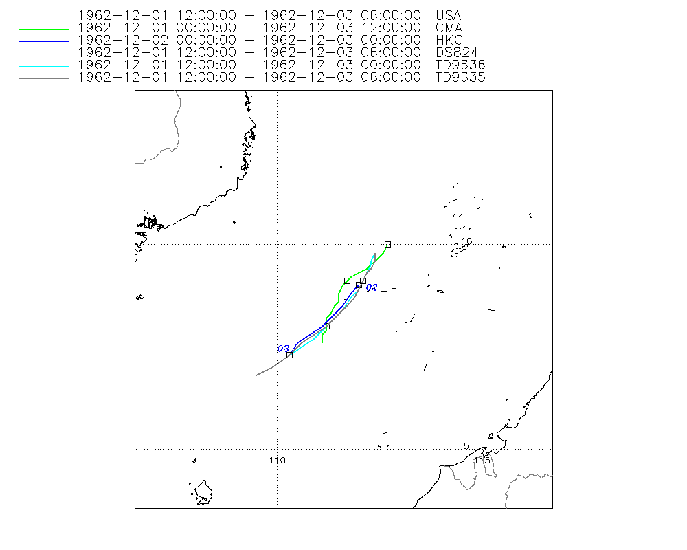
Severe Tropical Storm MARY (1962335N10113)
IBTrACS version v04r01. Visit
IBTrACS website for data access.
Please direct all questions to the
IBTrACS Q and A forum
Storm track
-
Intensity
-
Wind Radii
-
Intensity Data
-
Source Data
-
All data
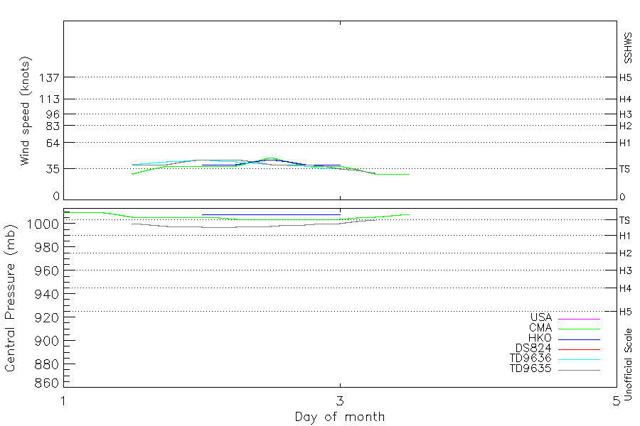
Summary Information
|
|
| Storm ID |
1962335N10113 |
| Start |
Dec 1 00Z |
| Max Intensity |
48 kt (Dec 2 12Z), 997 mb (Dec 2 00Z) |
| End |
Dec 3 12Z |
| ATCF IDs |
,WP291962 |
| Track status |
Best track data. |
|
Storm track plot
|
Intensity plots
|
Radial wind information
|
Position and Intensity Table
| BASIN |
ISO_TIME_________ |
NATURE |
LAT |
LON |
USA WIND |
CMA WIND |
CMA PRES |
HKO WIND |
HKO PRES |
DS824 WIND |
TD9636 WIND |
TD9635 WIND |
TD9635 PRES |
| |
|
|
degrees north |
degrees east |
kts |
kts |
mb |
kts |
mb |
kts |
kts |
kts |
mb |
| WP |
1962-12-01 00:00:00 |
DS |
10.00 |
112.70 |
|
|
1010 |
|
|
|
|
|
|
| WP |
03:00:00 |
DS |
9.80 |
112.60 |
|
|
1010 |
|
|
|
|
|
|
| WP |
06:00:00 |
DS |
9.70 |
112.50 |
|
|
1010 |
|
|
|
|
|
|
| WP |
09:00:00 |
DS |
9.60 |
112.40 |
|
|
1008 |
|
|
|
|
|
|
| WP |
12:00:00 |
TS |
9.70 |
112.40 |
40 |
29 |
1006 |
|
|
40 |
40 |
40 |
1000 |
| WP |
15:00:00 |
TS |
9.50 |
112.30 |
40 |
34 |
1006 |
|
|
40 |
41 |
40 |
999 |
| WP |
18:00:00 |
TS |
9.40 |
112.20 |
40 |
38 |
1006 |
|
|
40 |
43 |
40 |
998 |
| WP |
21:00:00 |
TS |
9.30 |
112.10 |
43 |
38 |
1006 |
|
|
43 |
44 |
43 |
998 |
| WP |
1962-12-02 00:00:00 |
TS |
9.10 |
112.00 |
45 |
38 |
1006 |
40 |
1008 |
45 |
45 |
45 |
997 |
| WP |
03:00:00 |
TS |
8.90 |
111.90 |
45 |
38 |
1005 |
40 |
1008 |
45 |
44 |
45 |
997 |
| WP |
06:00:00 |
TS |
8.70 |
111.80 |
45 |
38 |
1004 |
40 |
1008 |
45 |
43 |
45 |
997 |
| WP |
09:00:00 |
TS |
8.50 |
111.60 |
43 |
43 |
1004 |
43 |
1008 |
43 |
41 |
43 |
998 |
| WP |
12:00:00 |
TS |
8.30 |
111.40 |
40 |
48 |
1004 |
45 |
1008 |
40 |
40 |
40 |
998 |
| WP |
15:00:00 |
TS |
8.10 |
111.20 |
40 |
43 |
1004 |
43 |
1008 |
40 |
39 |
40 |
999 |
| WP |
18:00:00 |
TS |
7.90 |
110.90 |
40 |
38 |
1004 |
40 |
1008 |
40 |
38 |
40 |
999 |
| WP |
21:00:00 |
TS |
7.70 |
110.70 |
38 |
38 |
1004 |
40 |
1008 |
38 |
36 |
38 |
1000 |
| WP |
1962-12-03 00:00:00 |
TS |
7.50 |
110.50 |
35 |
38 |
1004 |
40 |
1008 |
35 |
35 |
35 |
1000 |
| WP |
03:00:00 |
TS |
7.40 |
110.40 |
33 |
34 |
1005 |
|
|
33 |
|
33 |
1002 |
| WP |
06:00:00 |
TS |
7.30 |
110.30 |
30 |
29 |
1006 |
|
|
30 |
|
30 |
1003 |
| WP |
09:00:00 |
TS |
7.70 |
111.10 |
|
29 |
1007 |
|
|
|
|
|
|
| WP |
12:00:00 |
TS |
7.60 |
111.10 |
|
29 |
1008 |
|
|
|
|
|
|
Source Information
| Agency |
Information |
| USA |
bwp291962.txt |
| TOKYO |
|
| CMA |
CH1962BST.txt:Storm=36:Mary |
| HKO |
tc-besttrack-data-current.txt:Line=1562:MARY |
| KMA |
|
| NEWDELHI |
|
| REUNION |
|
| BOM |
|
| NADI |
|
| WELLINGTON |
|
| DS824 |
w_npac.dat:435:MARY |
| TD9636 |
cons_worldwide_trop_cyclone_18710101-19891231-003:Line=19681 |
| TD9635 |
typhoons-analogs_19450101-19761231.corrected:Line=14788 |
| NEUMANN |
|
| MLC |
|
All available IBTrACS Data
| SEASON |
BASIN |
SUBBASIN |
ISO_TIME_________ |
NATURE |
LAT |
LON |
DIST2LAND |
LANDFALL |
IFLAG |
USA AGENCY |
USA ATCF_ID |
USA LAT |
USA LON |
USA WIND |
USA SSHS |
CMA LAT |
CMA LON |
CMA CAT |
CMA WIND |
CMA PRES |
HKO LAT |
HKO LON |
HKO CAT |
HKO WIND |
HKO PRES |
DS824 LAT |
DS824 LON |
DS824 STAGE |
DS824 WIND |
TD9636 LAT |
TD9636 LON |
TD9636 STAGE |
TD9636 WIND |
TD9635 LAT |
TD9635 LON |
TD9635 WIND |
TD9635 PRES |
TD9635 ROCI |
STORM SPEED |
STORM DIR |
| Year |
|
|
|
|
degrees north |
degrees east |
km |
km |
|
|
|
degrees north |
degrees east |
kts |
1 |
degrees north |
degrees east |
1 |
kts |
mb |
degrees north |
degrees east |
|
kts |
mb |
degrees north |
degrees east |
|
kts |
degrees north |
degrees east |
|
kts |
degrees north |
degrees east |
kts |
mb |
nmile |
kts |
degrees |
| 1962 |
WP |
MM |
1962-12-01 00:00:00 |
DS |
10.00 |
112.70 |
427 |
422 |
__O____________ |
|
|
|
|
|
-5 |
10.00 |
112.70 |
0 |
|
1010 |
|
|
|
|
|
|
|
|
|
|
|
|
|
|
|
|
|
|
4 |
215 |
| 1962 |
WP |
MM |
03:00:00 |
DS |
9.80 |
112.60 |
428 |
418 |
__P____________ |
|
|
|
|
|
-5 |
9.80 |
112.60 |
0 |
|
1010 |
|
|
|
|
|
|
|
|
|
|
|
|
|
|
|
|
|
|
4 |
215 |
| 1962 |
WP |
MM |
06:00:00 |
DS |
9.70 |
112.50 |
424 |
421 |
__O____________ |
|
|
|
|
|
-5 |
9.70 |
112.50 |
0 |
|
1010 |
|
|
|
|
|
|
|
|
|
|
|
|
|
|
|
|
|
|
3 |
215 |
| 1962 |
WP |
MM |
09:00:00 |
DS |
9.60 |
112.40 |
421 |
421 |
__P____________ |
|
|
|
|
|
-5 |
9.60 |
112.40 |
0 |
|
1008 |
|
|
|
|
|
|
|
|
|
|
|
|
|
|
|
|
|
|
2 |
250 |
| 1962 |
WP |
MM |
12:00:00 |
TS |
9.70 |
112.40 |
415 |
412 |
O_O_______OOO__ |
jtwc_wp |
WP291962 |
9.80 |
112.40 |
40 |
0 |
9.50 |
112.30 |
1 |
29 |
1006 |
|
|
|
|
|
9.80 |
112.40 |
TC |
40 |
9.80 |
112.40 |
2 |
40 |
9.80 |
112.40 |
40 |
1000 |
120 |
1 |
245 |
| 1962 |
WP |
MM |
15:00:00 |
TS |
9.50 |
112.30 |
419 |
415 |
P_P_______PPP__ |
|
WP291962 |
9.60 |
112.40 |
40 |
0 |
9.40 |
112.20 |
1 |
34 |
1006 |
|
|
|
|
|
9.60 |
112.40 |
TC |
40 |
9.60 |
112.30 |
2 |
41 |
9.60 |
112.40 |
40 |
999 |
120 |
3 |
205 |
| 1962 |
WP |
MM |
18:00:00 |
TS |
9.40 |
112.20 |
415 |
412 |
O_O_______OPO__ |
jtwc_wp |
WP291962 |
9.40 |
112.30 |
40 |
0 |
9.30 |
112.00 |
2 |
38 |
1006 |
|
|
|
|
|
9.40 |
112.30 |
TC |
40 |
9.50 |
112.30 |
2 |
43 |
9.40 |
112.30 |
40 |
998 |
120 |
3 |
210 |
| 1962 |
WP |
MM |
21:00:00 |
TS |
9.30 |
112.10 |
412 |
412 |
P_P_______PPP__ |
|
WP291962 |
9.30 |
112.20 |
43 |
0 |
9.20 |
111.80 |
2 |
38 |
1006 |
|
|
|
|
|
9.30 |
112.20 |
TC |
43 |
9.30 |
112.20 |
2 |
44 |
9.30 |
112.20 |
43 |
998 |
120 |
4 |
215 |
| 1962 |
WP |
MM |
1962-12-02 00:00:00 |
TS |
9.10 |
112.00 |
417 |
416 |
O_OO______OOO__ |
jtwc_wp |
WP291962 |
9.10 |
112.10 |
45 |
0 |
9.10 |
111.70 |
2 |
38 |
1006 |
9.00 |
112.00 |
TS |
40 |
1008 |
9.10 |
112.10 |
TC |
45 |
9.10 |
112.10 |
2 |
45 |
9.10 |
112.10 |
45 |
997 |
120 |
4 |
210 |
| 1962 |
WP |
MM |
03:00:00 |
TS |
8.90 |
111.90 |
423 |
422 |
P_PP______PPP__ |
|
WP291962 |
8.90 |
112.00 |
45 |
0 |
9.00 |
111.60 |
2 |
38 |
1005 |
8.90 |
111.90 |
TS |
40 |
1008 |
8.90 |
112.00 |
TC |
45 |
8.90 |
112.00 |
2 |
44 |
8.90 |
112.00 |
45 |
997 |
120 |
4 |
210 |
| 1962 |
WP |
MM |
06:00:00 |
TS |
8.70 |
111.80 |
430 |
423 |
O_OO______OPO__ |
jtwc_wp |
WP291962 |
8.70 |
111.90 |
45 |
0 |
8.80 |
111.50 |
2 |
38 |
1004 |
8.80 |
111.80 |
TS |
40 |
1008 |
8.70 |
111.90 |
TC |
45 |
8.70 |
111.80 |
2 |
43 |
8.70 |
111.90 |
45 |
997 |
120 |
5 |
215 |
| 1962 |
WP |
MM |
09:00:00 |
TS |
8.50 |
111.60 |
432 |
432 |
P_PP______PPP__ |
|
WP291962 |
8.50 |
111.70 |
43 |
0 |
8.60 |
111.50 |
2 |
43 |
1004 |
8.50 |
111.60 |
TS |
43 |
1008 |
8.50 |
111.70 |
TC |
43 |
8.40 |
111.60 |
2 |
41 |
8.50 |
111.70 |
43 |
998 |
120 |
6 |
220 |
| 1962 |
WP |
MM |
12:00:00 |
TS |
8.30 |
111.40 |
435 |
435 |
O_OO______OOO__ |
jtwc_wp |
WP291962 |
8.20 |
111.40 |
40 |
0 |
8.50 |
111.40 |
3 |
48 |
1004 |
8.20 |
111.30 |
TS |
45 |
1008 |
8.20 |
111.40 |
TC |
40 |
8.20 |
111.40 |
2 |
40 |
8.20 |
111.40 |
40 |
998 |
120 |
6 |
225 |
| 1962 |
WP |
MM |
15:00:00 |
TS |
8.10 |
111.20 |
441 |
438 |
P_PP______PPP__ |
|
WP291962 |
8.00 |
111.20 |
40 |
0 |
8.30 |
111.30 |
3 |
43 |
1004 |
8.00 |
111.10 |
TS |
43 |
1008 |
8.00 |
111.20 |
TC |
40 |
8.00 |
111.20 |
2 |
39 |
8.00 |
111.20 |
40 |
999 |
120 |
6 |
230 |
| 1962 |
WP |
MM |
18:00:00 |
TS |
7.90 |
110.90 |
440 |
440 |
O_OO______OPO__ |
jtwc_wp |
WP291962 |
7.80 |
110.90 |
40 |
0 |
8.20 |
111.20 |
2 |
38 |
1004 |
7.80 |
110.80 |
TS |
40 |
1008 |
7.80 |
110.90 |
TC |
40 |
7.70 |
110.90 |
2 |
38 |
7.80 |
110.90 |
40 |
999 |
120 |
6 |
230 |
| 1962 |
WP |
MM |
21:00:00 |
TS |
7.70 |
110.70 |
444 |
444 |
P_PP______PPP__ |
|
WP291962 |
7.60 |
110.60 |
38 |
0 |
8.10 |
111.20 |
2 |
38 |
1004 |
7.60 |
110.50 |
TS |
40 |
1008 |
7.60 |
110.60 |
TC |
38 |
7.50 |
110.60 |
2 |
36 |
7.60 |
110.60 |
38 |
1000 |
120 |
5 |
225 |
| 1962 |
WP |
MM |
1962-12-03 00:00:00 |
TS |
7.50 |
110.50 |
451 |
436 |
O_OO______OOO__ |
jtwc_wp |
WP291962 |
7.30 |
110.30 |
35 |
0 |
8.00 |
111.20 |
2 |
38 |
1004 |
7.30 |
110.30 |
TS |
40 |
1008 |
7.30 |
110.30 |
TC |
35 |
7.30 |
110.30 |
2 |
35 |
7.30 |
110.30 |
35 |
1000 |
120 |
4 |
230 |
| 1962 |
WP |
MM |
03:00:00 |
TS |
7.40 |
110.40 |
436 |
421 |
P_P_______P_P__ |
|
WP291962 |
7.00 |
109.90 |
33 |
-1 |
7.90 |
111.20 |
2 |
34 |
1005 |
|
|
|
|
|
7.00 |
109.90 |
TC |
33 |
|
|
|
|
7.00 |
109.90 |
33 |
1002 |
120 |
3 |
230 |
| 1962 |
WP |
MM |
06:00:00 |
TS |
7.30 |
110.30 |
421 |
421 |
O_O_______O_O__ |
jtwc_wp |
WP291962 |
6.80 |
109.50 |
30 |
-1 |
7.80 |
111.10 |
1 |
29 |
1006 |
|
|
|
|
|
6.80 |
109.50 |
TC |
30 |
|
|
|
|
6.80 |
109.50 |
30 |
1003 |
120 |
7 |
65 |
| 1962 |
WP |
MM |
09:00:00 |
TS |
7.70 |
111.10 |
472 |
464 |
__P____________ |
|
WP291962 |
|
|
|
-5 |
7.70 |
111.10 |
1 |
29 |
1007 |
|
|
|
|
|
|
|
|
|
|
|
|
|
|
|
|
|
|
8 |
70 |
| 1962 |
WP |
MM |
12:00:00 |
TS |
7.60 |
111.10 |
464 |
|
__O____________ |
|
|
|
|
|
-5 |
7.60 |
111.10 |
1 |
29 |
1008 |
|
|
|
|
|
|
|
|
|
|
|
|
|
|
|
|
|
|
2 |
0 |