1963
Tropical Cyclone (Gale) UNNAMED (1963350S12163)
IBTrACS version v04r01. Visit
IBTrACS website for data access.
Please direct all questions to the
IBTrACS Q and A forum
Storm track
-
Intensity
-
Wind Radii
-
Intensity Data
-
Source Data
-
All data
Summary Information
|
|
| Storm ID |
1963350S12163 |
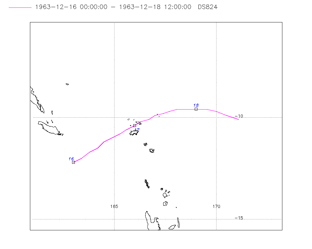
| Start |
Dec 16 00Z |
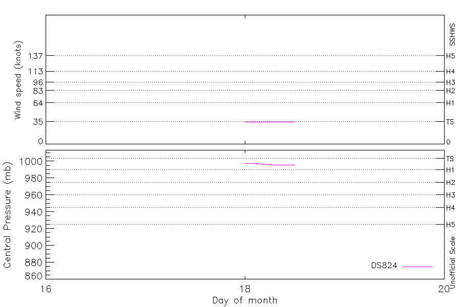
| Max Intensity |
35 kt (Dec 18 00Z), 996 mb (Dec 18 06Z) |
| End |
Dec 18 12Z |
| ATCF IDs |
|
| Track status |
Best track data. |
|
Storm track plot
|
Intensity plots
|
Radial wind information
No radial wind information for this storm
|
Position and Intensity Table
| BASIN |
ISO_TIME_________ |
NATURE |
LAT |
LON |
DS824 WIND |
DS824 PRES |
| |
|
|
degrees north |
degrees east |
kts |
mb |
| SP |
1963-12-16 00:00:00 |
TS |
-12.20 |
163.00 |
25 |
1003 |
| SP |
03:00:00 |
TS |
-12.00 |
163.40 |
|
|
| SP |
06:00:00 |
TS |
-11.70 |
163.80 |
|
|
| SP |
09:00:00 |
TS |
-11.50 |
164.20 |
|
|
| SP |
12:00:00 |
TS |
-11.20 |
164.50 |
|
|
| SP |
15:00:00 |
TS |
-11.00 |
164.90 |
|
|
| SP |
18:00:00 |
TS |
-10.80 |
165.30 |
|
|
| SP |
21:00:00 |
TS |
-10.60 |
165.60 |
|
|
| SP |
1963-12-17 00:00:00 |
TS |
-10.40 |
166.00 |
25 |
1002 |
| SP |
03:00:00 |
TS |
-10.20 |
166.30 |
|
|
| SP |
06:00:00 |
TS |
-10.10 |
166.70 |
|
|
| SP |
09:00:00 |
TS |
-9.90 |
167.00 |
|
|
| SP |
12:00:00 |
TS |
-9.80 |
167.40 |
|
|
| SP |
15:00:00 |
TS |
-9.70 |
167.70 |
|
|
| SP |
18:00:00 |
TS |
-9.60 |
168.10 |
|
|
| SP |
21:00:00 |
TS |
-9.60 |
168.50 |
|
|
| SP |
1963-12-18 00:00:00 |
TS |
-9.60 |
169.00 |
35 |
998 |
| SP |
03:00:00 |
TS |
-9.60 |
169.50 |
35 |
997 |
| SP |
06:00:00 |
TS |
-9.70 |
170.00 |
35 |
996 |
| SP |
09:00:00 |
TS |
-9.80 |
170.60 |
35 |
996 |
| SP |
12:00:00 |
TS |
-10.10 |
171.10 |
35 |
996 |
Source Information
| Agency |
Information |
| USA |
|
| TOKYO |
|
| CMA |
|
| HKO |
|
| KMA |
|
| NEWDELHI |
|
| REUNION |
|
| BOM |
|
| NADI |
|
| WELLINGTON |
|
| DS824 |
aus_area.dat:351:NOT NAMED |
| TD9636 |
|
| TD9635 |
|
| NEUMANN |
|
| MLC |
|
All available IBTrACS Data
| SEASON |
BASIN |
SUBBASIN |
ISO_TIME_________ |
NATURE |
LAT |
LON |
DIST2LAND |
LANDFALL |
IFLAG |
USA SSHS |
DS824 LAT |
DS824 LON |
DS824 STAGE |
DS824 WIND |
DS824 PRES |
STORM SPEED |
STORM DIR |
| Year |
|
|
|
|
degrees north |
degrees east |
km |
km |
|
1 |
degrees north |
degrees east |
|
kts |
mb |
kts |
degrees |
| 1964 |
SP |
MM |
1963-12-16 00:00:00 |
TS |
-12.20 |
163.00 |
174 |
169 |
__________O____ |
-5 |
-12.20 |
163.00 |
TC |
25 |
1003 |
9 |
60 |
| 1964 |
SP |
MM |
03:00:00 |
TS |
-12.00 |
163.40 |
180 |
171 |
__________P____ |
-5 |
-12.00 |
163.40 |
TC |
|
|
9 |
60 |
| 1964 |
SP |
MM |
06:00:00 |
TS |
-11.70 |
163.80 |
192 |
192 |
__________P____ |
-5 |
-11.70 |
163.80 |
TC |
|
|
9 |
60 |
| 1964 |
SP |
MM |
09:00:00 |
TS |
-11.50 |
164.20 |
221 |
218 |
__________P____ |
-5 |
-11.50 |
164.20 |
TC |
|
|
9 |
60 |
| 1964 |
SP |
MM |
12:00:00 |
TS |
-11.20 |
164.50 |
244 |
244 |
__________P____ |
-5 |
-11.20 |
164.50 |
TC |
|
|
9 |
60 |
| 1964 |
SP |
MM |
15:00:00 |
TS |
-11.00 |
164.90 |
284 |
284 |
__________P____ |
-5 |
-11.00 |
164.90 |
TC |
|
|
9 |
60 |
| 1964 |
SP |
MM |
18:00:00 |
TS |
-10.80 |
165.30 |
327 |
327 |
__________P____ |
-5 |
-10.80 |
165.30 |
TC |
|
|
8 |
60 |
| 1964 |
SP |
MM |
21:00:00 |
TS |
-10.60 |
165.60 |
361 |
361 |
__________P____ |
-5 |
-10.60 |
165.60 |
TC |
|
|
8 |
60 |
| 1964 |
SP |
MM |
1963-12-17 00:00:00 |
TS |
-10.40 |
166.00 |
406 |
406 |
__________O____ |
-5 |
-10.40 |
166.00 |
TC |
25 |
1002 |
8 |
60 |
| 1964 |
SP |
MM |
03:00:00 |
TS |
-10.20 |
166.30 |
441 |
441 |
__________P____ |
-5 |
-10.20 |
166.30 |
TC |
|
|
8 |
65 |
| 1964 |
SP |
MM |
06:00:00 |
TS |
-10.10 |
166.70 |
486 |
486 |
__________P____ |
-5 |
-10.10 |
166.70 |
TC |
|
|
7 |
65 |
| 1964 |
SP |
MM |
09:00:00 |
TS |
-9.90 |
167.00 |
522 |
522 |
__________P____ |
-5 |
-9.90 |
167.00 |
TC |
|
|
7 |
70 |
| 1964 |
SP |
MM |
12:00:00 |
TS |
-9.80 |
167.40 |
555 |
555 |
__________P____ |
-5 |
-9.80 |
167.40 |
TC |
|
|
7 |
75 |
| 1964 |
SP |
MM |
15:00:00 |
TS |
-9.70 |
167.70 |
572 |
572 |
__________P____ |
-5 |
-9.70 |
167.70 |
TC |
|
|
8 |
80 |
| 1964 |
SP |
MM |
18:00:00 |
TS |
-9.60 |
168.10 |
593 |
593 |
__________P____ |
-5 |
-9.60 |
168.10 |
TC |
|
|
8 |
85 |
| 1964 |
SP |
MM |
21:00:00 |
TS |
-9.60 |
168.50 |
607 |
607 |
__________P____ |
-5 |
-9.60 |
168.50 |
TC |
|
|
9 |
90 |
| 1964 |
SP |
MM |
1963-12-18 00:00:00 |
TS |
-9.60 |
169.00 |
627 |
627 |
__________O____ |
-5 |
-9.60 |
169.00 |
TC |
35 |
998 |
9 |
90 |
| 1964 |
SP |
MM |
03:00:00 |
TS |
-9.60 |
169.50 |
652 |
652 |
__________P____ |
-5 |
-9.60 |
169.50 |
TC |
35 |
997 |
10 |
95 |
| 1964 |
SP |
MM |
06:00:00 |
TS |
-9.70 |
170.00 |
670 |
670 |
__________O____ |
-5 |
-9.70 |
170.00 |
TC |
35 |
996 |
11 |
100 |
| 1964 |
SP |
MM |
09:00:00 |
TS |
-9.80 |
170.60 |
695 |
686 |
__________P____ |
-5 |
-9.90 |
170.50 |
TC |
35 |
996 |
12 |
110 |
| 1964 |
SP |
MM |
12:00:00 |
TS |
-10.10 |
171.10 |
699 |
|
__________O____ |
-5 |
-10.10 |
171.10 |
TC |
35 |
996 |
12 |
115 |