1965
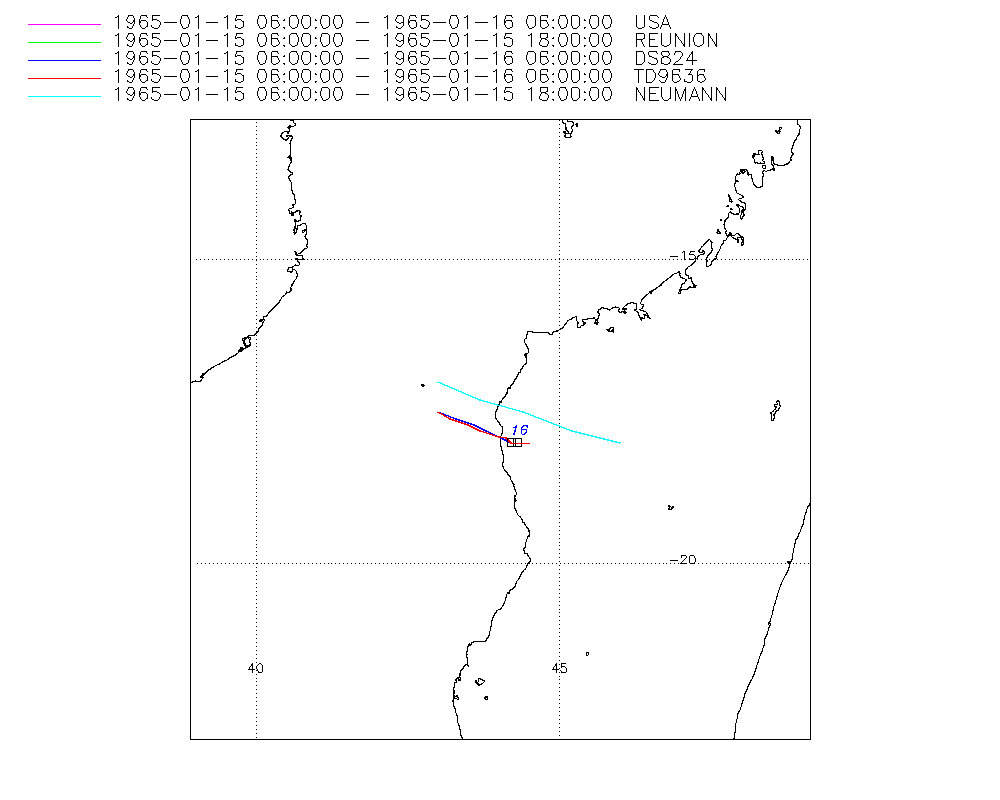
Moderate Tropical Storm HAZEL (1965015S17043)
IBTrACS version v04r01. Visit
IBTrACS website for data access.
Please direct all questions to the
IBTrACS Q and A forum
Storm track
-
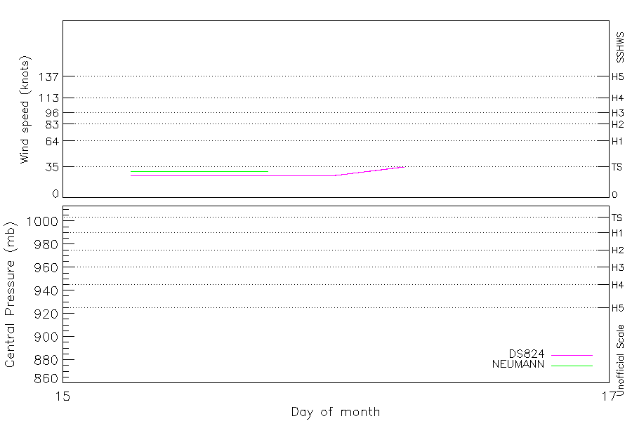
Intensity
-
Wind Radii
-
Intensity Data
-
Source Data
-
All data
Summary Information
|
|
| Storm ID |
1965015S17043 |
| Start |
Jan 15 06Z |
| Landfall |
Jan 15 15Z |
| Max Intensity |
35 kt (Jan 16 06Z) |
| End |
Jan 16 06Z |
| ATCF IDs |
SH181965 |
| Track status |
Best track data. |
|
Storm track plot
|
Intensity plots
|
Radial wind information
No radial wind information for this storm
|
Position and Intensity Table
| BASIN |
ISO_TIME_________ |
NATURE |
LAT |
LON |
DS824 WIND |
NEUMANN WIND |
| |
|
|
degrees north |
degrees east |
kts |
kts |
| SI |
1965-01-15 06:00:00 |
TS |
-17.30 |
43.00 |
25 |
30 |
| SI |
09:00:00 |
TS |
-17.50 |
43.50 |
25 |
30 |
| SI |
12:00:00 |
MX |
-17.60 |
43.90 |
25 |
30 |
| SI |
15:00:00 |
MX |
-17.80 |
44.10 |
25 |
30 |
| SI |
18:00:00 |
MX |
-17.90 |
44.30 |
25 |
30 |
| SI |
21:00:00 |
TS |
-18.00 |
44.20 |
25 |
|
| SI |
1965-01-16 00:00:00 |
TS |
-18.00 |
44.30 |
25 |
|
| SI |
03:00:00 |
TS |
-18.00 |
44.40 |
30 |
|
| SI |
06:00:00 |
TS |
-18.00 |
44.50 |
35 |
|
Source Information
| Agency |
Information |
| USA |
bsh181965.txt |
| TOKYO |
|
| CMA |
|
| HKO |
|
| KMA |
|
| NEWDELHI |
|
| REUNION |
WMO-Best-Tracks.txt:Line=6235:hazel |
| BOM |
|
| NADI |
|
| WELLINGTON |
|
| DS824 |
s_hem.dat:955:18S |
| TD9636 |
cons_worldwide_trop_cyclone_18710101-19891231-005:Line=8650 |
| TD9635 |
|
| NEUMANN |
tracks.sh:Storm=132:HAZEL:BSH1865:Reunion |
| MLC |
|
All available IBTrACS Data
| SEASON |
BASIN |
SUBBASIN |
ISO_TIME_________ |
NATURE |
LAT |
LON |
WMO AGENCY |
DIST2LAND |
LANDFALL |
IFLAG |
USA AGENCY |
USA ATCF_ID |
USA LAT |
USA LON |
USA SSHS |
REUNION LAT |
REUNION LON |
REUNION TYPE |
REUNION TNUM |
DS824 LAT |
DS824 LON |
DS824 STAGE |
DS824 WIND |
TD9636 LAT |
TD9636 LON |
TD9636 STAGE |
NEUMANN LAT |
NEUMANN LON |
NEUMANN CLASS |
NEUMANN WIND |
STORM SPEED |
STORM DIR |
| Year |
|
|
|
|
degrees north |
degrees east |
|
km |
km |
|
|
|
degrees north |
degrees east |
1 |
degrees north |
degrees east |
|
1 |
degrees north |
degrees east |
|
kts |
degrees north |
degrees east |
|
degrees north |
degrees east |
|
kts |
kts |
degrees |
| 1965 |
SI |
MM |
1965-01-15 06:00:00 |
TS |
-17.30 |
43.00 |
reunion |
98 |
53 |
O_____O___OO_O_ |
jtwc_sh |
SH181965 |
-17.50 |
43.00 |
-5 |
-17.00 |
43.00 |
2 |
9.90 |
-17.50 |
43.00 |
TC |
25 |
-17.50 |
43.00 |
7 |
-17.00 |
43.00 |
TC |
30 |
9 |
110 |
| 1965 |
SI |
MM |
09:00:00 |
TS |
-17.50 |
43.50 |
|
42 |
10 |
P_____P___PP_P_ |
|
SH181965 |
-17.60 |
43.30 |
-5 |
-17.30 |
43.70 |
2 |
|
-17.60 |
43.30 |
TC |
25 |
-17.60 |
43.20 |
7 |
-17.30 |
43.70 |
TC |
30 |
9 |
110 |
| 1965 |
SI |
MM |
12:00:00 |
MX |
-17.60 |
43.90 |
reunion |
10 |
0 |
O_____O___OP_O_ |
jtwc_sh |
SH181965 |
-17.70 |
43.60 |
-5 |
-17.50 |
44.40 |
6 |
9.90 |
-17.70 |
43.60 |
TC |
25 |
-17.70 |
43.50 |
7 |
-17.50 |
44.40 |
TC |
30 |
7 |
115 |
| 1965 |
SI |
MM |
15:00:00 |
MX |
-17.80 |
44.10 |
|
0 |
0 |
P_____P___PP_P_ |
|
SH181965 |
-17.80 |
43.80 |
-5 |
-17.80 |
45.20 |
6 |
|
-17.80 |
43.80 |
TC |
25 |
-17.80 |
43.70 |
7 |
-17.80 |
45.20 |
TC |
30 |
5 |
130 |
| 1965 |
SI |
MM |
18:00:00 |
MX |
-17.90 |
44.30 |
reunion |
0 |
0 |
O_____O___OO_O_ |
jtwc_sh |
SH181965 |
-17.90 |
44.00 |
-5 |
-18.00 |
46.00 |
6 |
9.90 |
-17.90 |
44.00 |
TC |
25 |
-17.90 |
44.00 |
1 |
-18.00 |
46.00 |
TC |
30 |
2 |
0 |
| 1965 |
SI |
MM |
21:00:00 |
TS |
-18.00 |
44.20 |
|
0 |
0 |
P_________PP___ |
|
SH181965 |
-18.00 |
44.20 |
-5 |
|
|
|
|
-18.00 |
44.20 |
TC |
25 |
-17.90 |
44.10 |
1 |
|
|
|
|
1 |
0 |
| 1965 |
SI |
MM |
1965-01-16 00:00:00 |
TS |
-18.00 |
44.30 |
|
0 |
0 |
O_________OP___ |
jtwc_sh |
SH181965 |
-18.00 |
44.30 |
-5 |
|
|
|
|
-18.00 |
44.30 |
TC |
25 |
-18.00 |
44.20 |
1 |
|
|
|
|
2 |
100 |
| 1965 |
SI |
MM |
03:00:00 |
TS |
-18.00 |
44.40 |
|
0 |
0 |
P_________PP___ |
|
SH181965 |
-18.00 |
44.40 |
-5 |
|
|
|
|
-18.00 |
44.40 |
TC |
30 |
-18.00 |
44.40 |
1 |
|
|
|
|
2 |
95 |
| 1965 |
SI |
MM |
06:00:00 |
TS |
-18.00 |
44.50 |
|
0 |
|
O_________OO___ |
jtwc_sh |
SH181965 |
-18.00 |
44.50 |
-5 |
|
|
|
|
-18.00 |
44.50 |
TC |
35 |
-18.00 |
44.50 |
2 |
|
|
|
|
2 |
90 |