1965
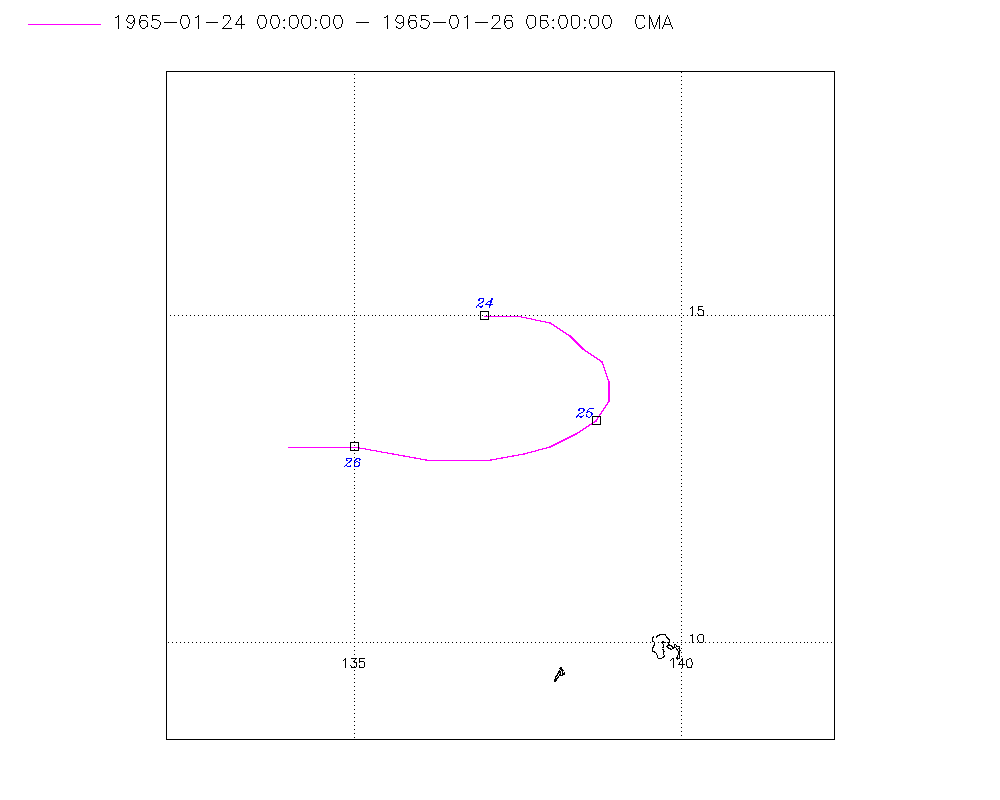
Tropical Depression UNNAMED (1965024N15137)
IBTrACS version v04r01. Visit
IBTrACS website for data access.
Please direct all questions to the
IBTrACS Q and A forum
Storm track
-
Intensity
-
Wind Radii
-
Intensity Data
-
Source Data
-
All data
Summary Information
|
|
| Storm ID |
1965024N15137 |
| Start |
Jan 24 00Z |
| Max Intensity |
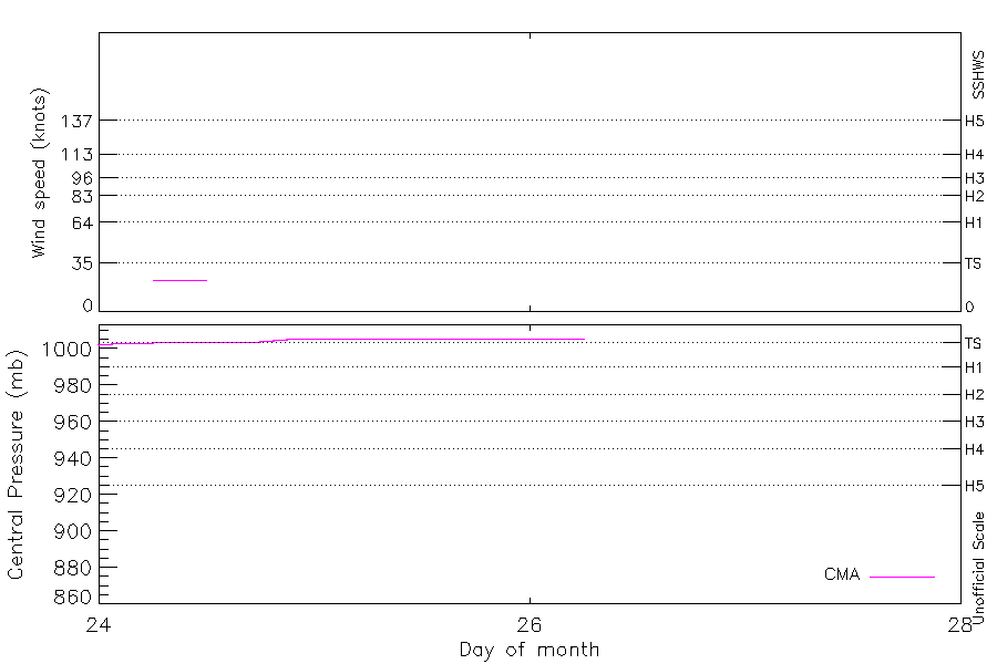
23 kt (Jan 24 06Z) |
| End |
Jan 26 06Z |
| ATCF IDs |
|
| Track status |
Best track data. |
|
Storm track plot
|
Intensity plots
|
Radial wind information
No radial wind information for this storm
|
Position and Intensity Table
| BASIN |
ISO_TIME_________ |
NATURE |
LAT |
LON |
CMA WIND |
CMA PRES |
| |
|
|
degrees north |
degrees east |
kts |
mb |
| WP |
1965-01-24 00:00:00 |
DS |
15.00 |
137.00 |
|
1002 |
| WP |
03:00:00 |
DS |
15.00 |
137.50 |
|
1003 |
| WP |
06:00:00 |
TS |
14.90 |
138.00 |
23 |
1003 |
| WP |
09:00:00 |
TS |
14.70 |
138.30 |
23 |
1004 |
| WP |
12:00:00 |
TS |
14.50 |
138.50 |
23 |
1004 |
| WP |
15:00:00 |
TS |
14.30 |
138.80 |
|
1004 |
| WP |
18:00:00 |
DS |
14.00 |
138.90 |
|
1004 |
| WP |
21:00:00 |
DS |
13.70 |
138.90 |
|
1005 |
| WP |
1965-01-25 00:00:00 |
DS |
13.40 |
138.70 |
|
1006 |
| WP |
03:00:00 |
DS |
13.20 |
138.40 |
|
1006 |
| WP |
06:00:00 |
DS |
13.00 |
138.00 |
|
1006 |
| WP |
09:00:00 |
DS |
12.90 |
137.60 |
|
1006 |
| WP |
12:00:00 |
DS |
12.80 |
137.10 |
|
1006 |
| WP |
15:00:00 |
DS |
12.80 |
136.60 |
|
1006 |
| WP |
18:00:00 |
DS |
12.80 |
136.10 |
|
1006 |
| WP |
21:00:00 |
DS |
12.90 |
135.60 |
|
1006 |
| WP |
1965-01-26 00:00:00 |
DS |
13.00 |
135.00 |
|
1006 |
| WP |
03:00:00 |
DS |
13.00 |
134.50 |
|
1006 |
| WP |
06:00:00 |
DS |
13.00 |
134.00 |
|
1006 |
Source Information
| Agency |
Information |
| USA |
|
| TOKYO |
|
| CMA |
CH1965BST.txt:Storm=4:(nameless) |
| HKO |
|
| KMA |
|
| NEWDELHI |
|
| REUNION |
|
| BOM |
|
| NADI |
|
| WELLINGTON |
|
| DS824 |
|
| TD9636 |
|
| TD9635 |
|
| NEUMANN |
|
| MLC |
|
All available IBTrACS Data
| SEASON |
BASIN |
SUBBASIN |
ISO_TIME_________ |
NATURE |
LAT |
LON |
DIST2LAND |
LANDFALL |
IFLAG |
USA SSHS |
CMA LAT |
CMA LON |
CMA CAT |
CMA WIND |
CMA PRES |
STORM SPEED |
STORM DIR |
| Year |
|
|
|
|
degrees north |
degrees east |
km |
km |
|
1 |
degrees north |
degrees east |
1 |
kts |
mb |
kts |
degrees |
| 1965 |
WP |
MM |
1965-01-24 00:00:00 |
DS |
15.00 |
137.00 |
1282 |
1282 |
__O____________ |
-5 |
15.00 |
137.00 |
0 |
|
1002 |
11 |
90 |
| 1965 |
WP |
MM |
03:00:00 |
DS |
15.00 |
137.50 |
1334 |
1334 |
__P____________ |
-5 |
15.00 |
137.50 |
0 |
|
1003 |
10 |
95 |
| 1965 |
WP |
MM |
06:00:00 |
TS |
14.90 |
138.00 |
1385 |
1385 |
__O____________ |
-5 |
14.90 |
138.00 |
1 |
23 |
1003 |
8 |
110 |
| 1965 |
WP |
MM |
09:00:00 |
TS |
14.70 |
138.30 |
1412 |
1412 |
__P____________ |
-5 |
14.70 |
138.30 |
1 |
23 |
1004 |
6 |
130 |
| 1965 |
WP |
MM |
12:00:00 |
TS |
14.50 |
138.50 |
1430 |
1430 |
__O____________ |
-5 |
14.50 |
138.50 |
1 |
23 |
1004 |
6 |
135 |
| 1965 |
WP |
MM |
15:00:00 |
TS |
14.30 |
138.80 |
1458 |
1453 |
__P____________ |
-5 |
14.30 |
138.80 |
1 |
|
1004 |
6 |
140 |
| 1965 |
WP |
MM |
18:00:00 |
DS |
14.00 |
138.90 |
1461 |
1455 |
__O____________ |
-5 |
14.00 |
138.90 |
0 |
|
1004 |
6 |
170 |
| 1965 |
WP |
MM |
21:00:00 |
DS |
13.70 |
138.90 |
1455 |
1428 |
__P____________ |
-5 |
13.70 |
138.90 |
0 |
|
1005 |
6 |
200 |
| 1965 |
WP |
MM |
1965-01-25 00:00:00 |
DS |
13.40 |
138.70 |
1428 |
1392 |
__O____________ |
-5 |
13.40 |
138.70 |
0 |
|
1006 |
7 |
220 |
| 1965 |
WP |
MM |
03:00:00 |
DS |
13.20 |
138.40 |
1392 |
1346 |
__P____________ |
-5 |
13.20 |
138.40 |
0 |
|
1006 |
8 |
240 |
| 1965 |
WP |
MM |
06:00:00 |
DS |
13.00 |
138.00 |
1346 |
1301 |
__O____________ |
-5 |
13.00 |
138.00 |
0 |
|
1006 |
9 |
250 |
| 1965 |
WP |
MM |
09:00:00 |
DS |
12.90 |
137.60 |
1301 |
1246 |
__P____________ |
-5 |
12.90 |
137.60 |
0 |
|
1006 |
9 |
255 |
| 1965 |
WP |
MM |
12:00:00 |
DS |
12.80 |
137.10 |
1246 |
1192 |
__O____________ |
-5 |
12.80 |
137.10 |
0 |
|
1006 |
9 |
265 |
| 1965 |
WP |
MM |
15:00:00 |
DS |
12.80 |
136.60 |
1192 |
1139 |
__P____________ |
-5 |
12.80 |
136.60 |
0 |
|
1006 |
10 |
270 |
| 1965 |
WP |
MM |
18:00:00 |
DS |
12.80 |
136.10 |
1139 |
1087 |
__O____________ |
-5 |
12.80 |
136.10 |
0 |
|
1006 |
10 |
275 |
| 1965 |
WP |
MM |
21:00:00 |
DS |
12.90 |
135.60 |
1087 |
1025 |
__P____________ |
-5 |
12.90 |
135.60 |
0 |
|
1006 |
11 |
280 |
| 1965 |
WP |
MM |
1965-01-26 00:00:00 |
DS |
13.00 |
135.00 |
1025 |
972 |
__O____________ |
-5 |
13.00 |
135.00 |
0 |
|
1006 |
10 |
275 |
| 1965 |
WP |
MM |
03:00:00 |
DS |
13.00 |
134.50 |
972 |
920 |
__P____________ |
-5 |
13.00 |
134.50 |
0 |
|
1006 |
10 |
270 |
| 1965 |
WP |
MM |
06:00:00 |
DS |
13.00 |
134.00 |
920 |
|
__O____________ |
-5 |
13.00 |
134.00 |
0 |
|
1006 |
10 |
265 |