1966
Tropical Depression UNNAMED (1966243N12112)
IBTrACS version v04r01. Visit
IBTrACS website for data access.
Please direct all questions to the
IBTrACS Q and A forum
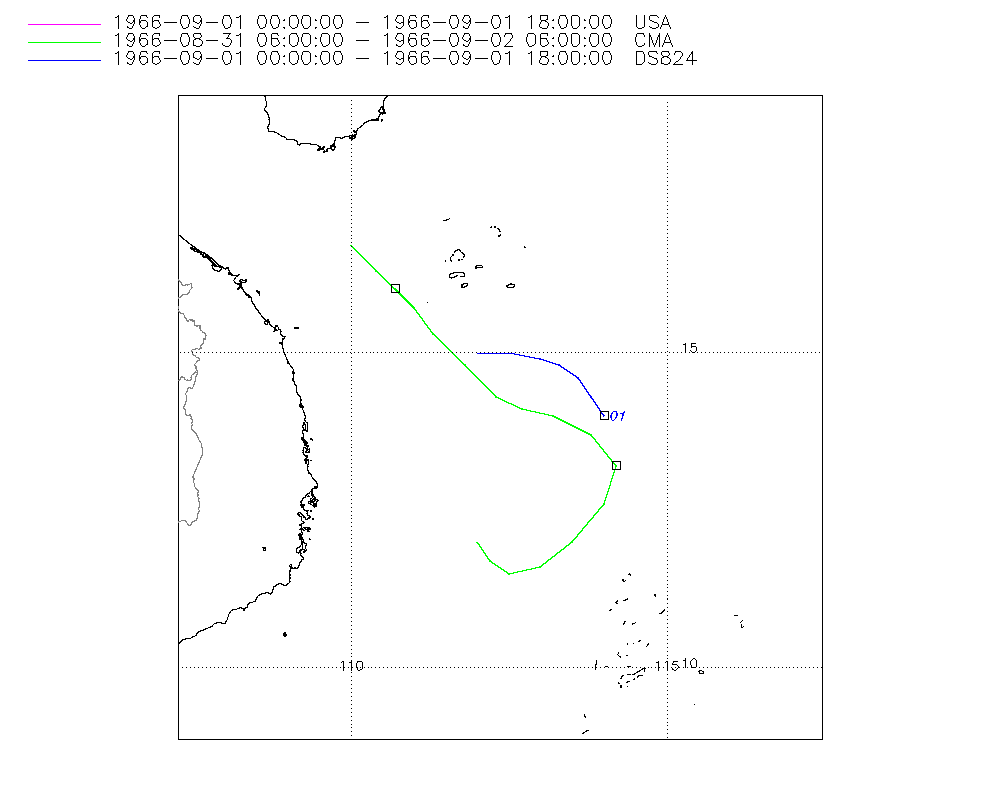
Storm track
-
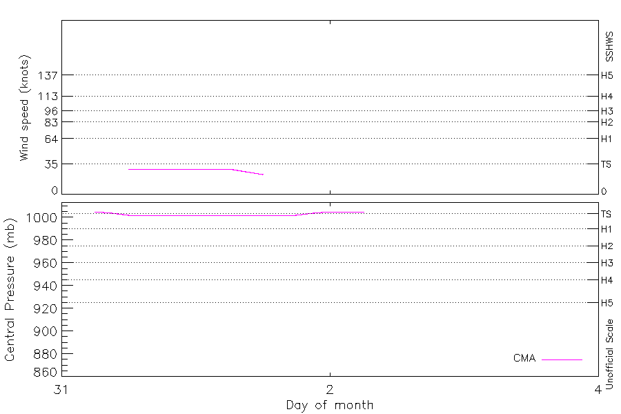
Intensity
-
Wind Radii
-
Intensity Data
-
Source Data
-
All data
Summary Information
|
|
| Storm ID |
1966243N12112 |
| Start |
Aug 31 06Z |
| Max Intensity |
29 kt (Aug 31 12Z) |
| End |
Sep 2 06Z |
| ATCF IDs |
,WP321966 |
| Track status |
Best track data. |
|
Storm track plot
|
Intensity plots
|
Radial wind information
No radial wind information for this storm
|
Position and Intensity Table
| BASIN |
ISO_TIME_________ |
NATURE |
LAT |
LON |
CMA WIND |
CMA PRES |
| |
|
|
degrees north |
degrees east |
kts |
mb |
| WP |
1966-08-31 06:00:00 |
DS |
12.00 |
112.00 |
|
1005 |
| WP |
09:00:00 |
DS |
11.70 |
112.20 |
|
1004 |
| WP |
12:00:00 |
TS |
11.50 |
112.50 |
29 |
1002 |
| WP |
15:00:00 |
TS |
11.60 |
113.00 |
29 |
1002 |
| WP |
18:00:00 |
TS |
12.00 |
113.50 |
29 |
1002 |
| WP |
21:00:00 |
TS |
12.60 |
114.00 |
29 |
1002 |
| WP |
1966-09-01 00:00:00 |
TS |
13.50 |
114.10 |
29 |
1002 |
| WP |
03:00:00 |
TS |
14.00 |
113.80 |
29 |
1002 |
| WP |
06:00:00 |
TS |
14.40 |
113.40 |
29 |
1002 |
| WP |
09:00:00 |
TS |
14.60 |
113.10 |
26 |
1002 |
| WP |
12:00:00 |
TS |
14.70 |
112.70 |
23 |
1002 |
| WP |
15:00:00 |
TS |
14.90 |
112.20 |
|
1002 |
| WP |
18:00:00 |
MX |
15.20 |
111.50 |
|
1002 |
| WP |
21:00:00 |
DS |
15.70 |
111.00 |
|
1004 |
| WP |
1966-09-02 00:00:00 |
DS |
16.00 |
110.70 |
|
1005 |
| WP |
03:00:00 |
DS |
16.30 |
110.40 |
|
1005 |
| WP |
06:00:00 |
DS |
16.70 |
110.00 |
|
1005 |
Source Information
| Agency |
Information |
| USA |
bwp321966.txt |
| TOKYO |
|
| CMA |
CH1966BST.txt:Storm=22:(nameless) |
| HKO |
|
| KMA |
|
| NEWDELHI |
|
| REUNION |
|
| BOM |
|
| NADI |
|
| WELLINGTON |
|
| DS824 |
w_npac.dat:568:19W |
| TD9636 |
|
| TD9635 |
|
| NEUMANN |
|
| MLC |
|
All available IBTrACS Data
| SEASON |
BASIN |
SUBBASIN |
ISO_TIME_________ |
NATURE |
LAT |
LON |
DIST2LAND |
LANDFALL |
IFLAG |
USA AGENCY |
USA ATCF_ID |
USA LAT |
USA LON |
USA STATUS |
USA SSHS |
CMA LAT |
CMA LON |
CMA CAT |
CMA WIND |
CMA PRES |
DS824 LAT |
DS824 LON |
DS824 STAGE |
STORM SPEED |
STORM DIR |
| Year |
|
|
|
|
degrees north |
degrees east |
km |
km |
|
|
|
degrees north |
degrees east |
|
1 |
degrees north |
degrees east |
1 |
kts |
mb |
degrees north |
degrees east |
|
kts |
degrees |
| 1966 |
WP |
MM |
1966-08-31 06:00:00 |
DS |
12.00 |
112.00 |
279 |
279 |
__O____________ |
|
|
|
|
|
-5 |
12.00 |
112.00 |
0 |
|
1005 |
|
|
|
8 |
150 |
| 1966 |
WP |
MM |
09:00:00 |
DS |
11.70 |
112.20 |
310 |
310 |
__P____________ |
|
|
|
|
|
-5 |
11.70 |
112.20 |
0 |
|
1004 |
|
|
|
7 |
135 |
| 1966 |
WP |
MM |
12:00:00 |
TS |
11.50 |
112.50 |
348 |
348 |
__O____________ |
|
|
|
|
|
-5 |
11.50 |
112.50 |
1 |
29 |
1002 |
|
|
|
8 |
95 |
| 1966 |
WP |
MM |
15:00:00 |
TS |
11.60 |
113.00 |
396 |
393 |
__P____________ |
|
|
|
|
|
-5 |
11.60 |
113.00 |
1 |
29 |
1002 |
|
|
|
11 |
65 |
| 1966 |
WP |
MM |
18:00:00 |
TS |
12.00 |
113.50 |
440 |
440 |
__O____________ |
|
|
|
|
|
-5 |
12.00 |
113.50 |
1 |
29 |
1002 |
|
|
|
14 |
45 |
| 1966 |
WP |
MM |
21:00:00 |
TS |
12.60 |
114.00 |
488 |
488 |
__P____________ |
|
|
|
|
|
-5 |
12.60 |
114.00 |
1 |
29 |
1002 |
|
|
|
16 |
25 |
| 1966 |
WP |
MM |
1966-09-01 00:00:00 |
TS |
13.50 |
114.10 |
502 |
481 |
O_O_______O____ |
jtwc_wp |
WP321966 |
14.00 |
114.00 |
TD |
-5 |
13.20 |
114.20 |
1 |
29 |
1002 |
14.00 |
114.00 |
TC |
14 |
355 |
| 1966 |
WP |
MM |
03:00:00 |
TS |
14.00 |
113.80 |
481 |
455 |
P_P_______P____ |
|
WP321966 |
14.30 |
113.80 |
TD |
-5 |
13.70 |
113.80 |
1 |
29 |
1002 |
14.30 |
113.80 |
TC |
11 |
325 |
| 1966 |
WP |
MM |
06:00:00 |
TS |
14.40 |
113.40 |
445 |
425 |
O_O_______O____ |
jtwc_wp |
WP321966 |
14.60 |
113.60 |
TD |
-5 |
14.00 |
113.20 |
1 |
29 |
1002 |
14.60 |
113.60 |
TC |
9 |
310 |
| 1966 |
WP |
MM |
09:00:00 |
TS |
14.60 |
113.10 |
417 |
377 |
P_P_______P____ |
|
WP321966 |
14.80 |
113.30 |
TD |
-5 |
14.10 |
112.70 |
1 |
26 |
1002 |
14.80 |
113.30 |
TC |
8 |
295 |
| 1966 |
WP |
MM |
12:00:00 |
TS |
14.70 |
112.70 |
377 |
328 |
O_O_______O____ |
jtwc_wp |
WP321966 |
14.90 |
113.00 |
TD |
-5 |
14.30 |
112.30 |
1 |
23 |
1002 |
14.90 |
113.00 |
TC |
10 |
285 |
| 1966 |
WP |
MM |
15:00:00 |
TS |
14.90 |
112.20 |
331 |
272 |
P_P_______P____ |
|
WP321966 |
15.00 |
112.50 |
TD |
-5 |
14.80 |
111.80 |
1 |
|
1002 |
15.00 |
112.50 |
TC |
13 |
295 |
| 1966 |
WP |
MM |
18:00:00 |
MX |
15.20 |
111.50 |
263 |
227 |
O_O_______O____ |
jtwc_wp |
WP321966 |
15.00 |
112.00 |
TD |
-5 |
15.30 |
111.30 |
0 |
|
1002 |
15.00 |
112.00 |
TC |
14 |
305 |
| 1966 |
WP |
MM |
21:00:00 |
DS |
15.70 |
111.00 |
232 |
208 |
__P____________ |
|
WP321966 |
|
|
TD |
-5 |
15.70 |
111.00 |
0 |
|
1004 |
|
|
|
11 |
315 |
| 1966 |
WP |
MM |
1966-09-02 00:00:00 |
DS |
16.00 |
110.70 |
212 |
202 |
__O____________ |
|
|
|
|
|
-5 |
16.00 |
110.70 |
0 |
|
1005 |
|
|
|
9 |
320 |
| 1966 |
WP |
MM |
03:00:00 |
DS |
16.30 |
110.40 |
202 |
170 |
__P____________ |
|
|
|
|
|
-5 |
16.30 |
110.40 |
0 |
|
1005 |
|
|
|
10 |
315 |
| 1966 |
WP |
MM |
06:00:00 |
DS |
16.70 |
110.00 |
170 |
|
__O____________ |
|
|
|
|
|
-5 |
16.70 |
110.00 |
0 |
|
1005 |
|
|
|
10 |
315 |