1969
Tropical Depression UNNAMED (1969052N05155)
IBTrACS version v04r01. Visit
IBTrACS website for data access.
Please direct all questions to the
IBTrACS Q and A forum
Storm track
-
Intensity
-
Wind Radii
-
Intensity Data
-
Source Data
-
All data
Summary Information
|
|
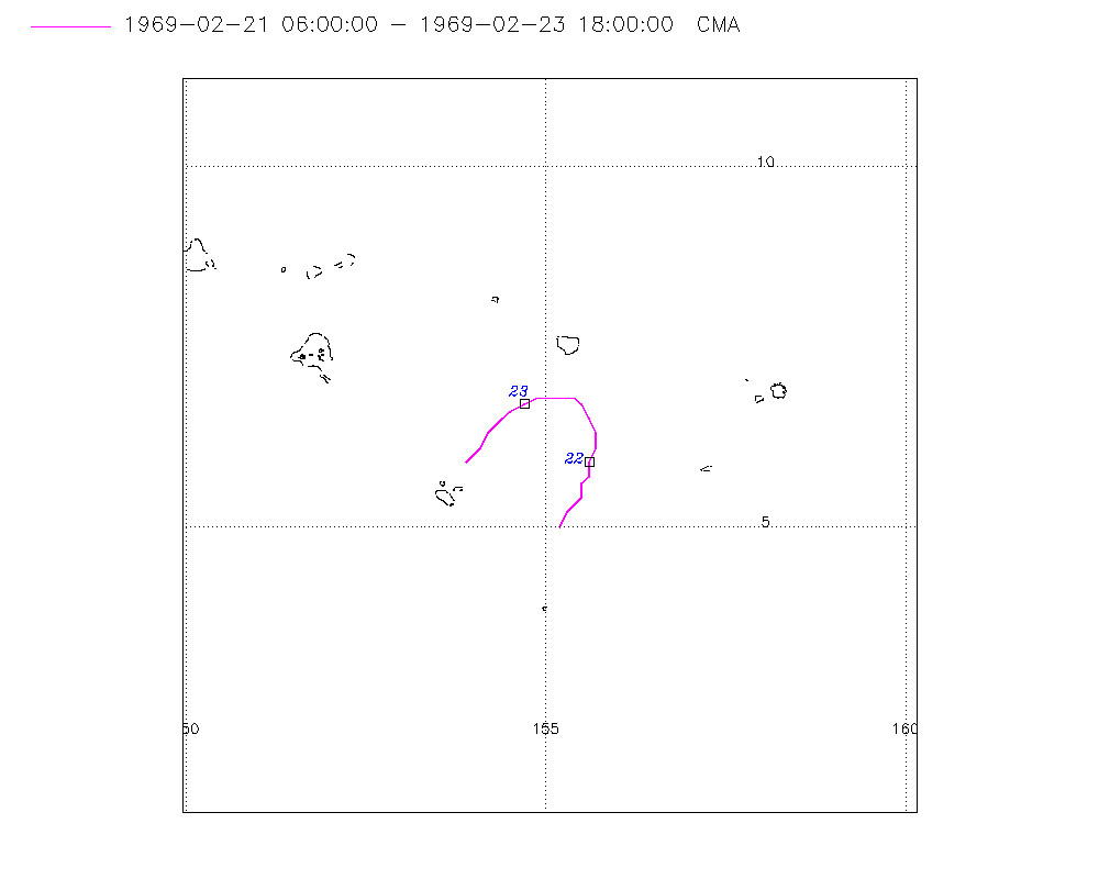
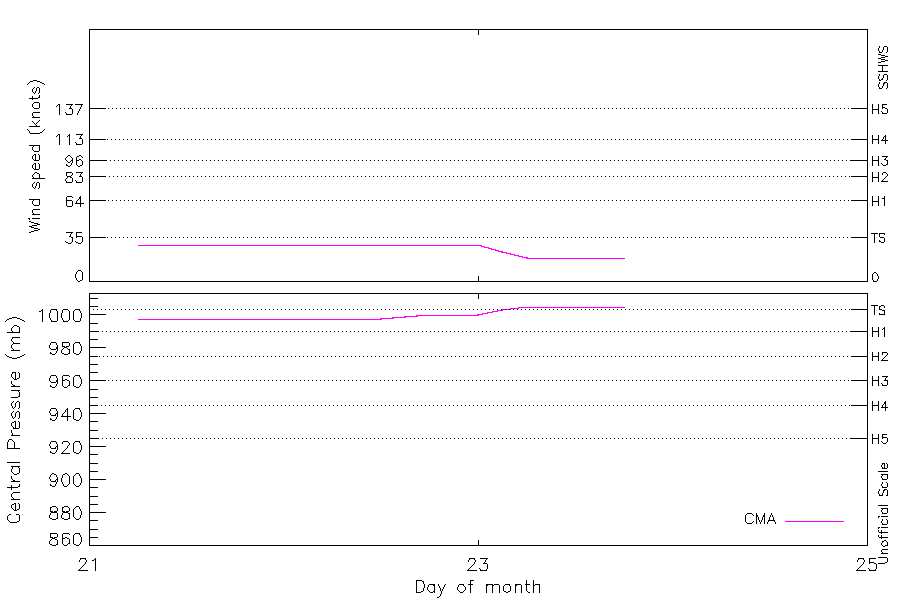
| Storm ID |
1969052N05155 |
| Start |
Feb 21 06Z |
| Max Intensity |
29 kt (Feb 21 09Z), 998 mb (Feb 21 09Z) |
| End |
Feb 23 18Z |
| ATCF IDs |
|
| Track status |
Best track data. |
|
Storm track plot
|
Intensity plots
|
Radial wind information
No radial wind information for this storm
|
Position and Intensity Table
| BASIN |
ISO_TIME_________ |
NATURE |
LAT |
LON |
CMA WIND |
CMA PRES |
| |
|
|
degrees north |
degrees east |
kts |
mb |
| WP |
1969-02-21 06:00:00 |
TS |
5.00 |
155.20 |
29 |
998 |
| WP |
09:00:00 |
TS |
5.20 |
155.30 |
29 |
998 |
| WP |
12:00:00 |
TS |
5.30 |
155.40 |
29 |
998 |
| WP |
15:00:00 |
TS |
5.40 |
155.50 |
29 |
998 |
| WP |
18:00:00 |
TS |
5.60 |
155.50 |
29 |
998 |
| WP |
21:00:00 |
TS |
5.70 |
155.60 |
29 |
998 |
| WP |
1969-02-22 00:00:00 |
TS |
5.90 |
155.60 |
29 |
998 |
| WP |
03:00:00 |
TS |
6.10 |
155.70 |
29 |
998 |
| WP |
06:00:00 |
TS |
6.30 |
155.70 |
29 |
998 |
| WP |
09:00:00 |
TS |
6.50 |
155.60 |
29 |
998 |
| WP |
12:00:00 |
TS |
6.70 |
155.50 |
29 |
998 |
| WP |
15:00:00 |
TS |
6.80 |
155.40 |
29 |
999 |
| WP |
18:00:00 |
TS |
6.80 |
155.20 |
29 |
1000 |
| WP |
21:00:00 |
TS |
6.80 |
154.90 |
29 |
1000 |
| WP |
1969-02-23 00:00:00 |
TS |
6.70 |
154.70 |
29 |
1000 |
| WP |
03:00:00 |
TS |
6.60 |
154.50 |
24 |
1003 |
| WP |
06:00:00 |
DS |
6.50 |
154.40 |
19 |
1005 |
| WP |
09:00:00 |
DS |
6.40 |
154.30 |
19 |
1005 |
| WP |
12:00:00 |
DS |
6.30 |
154.20 |
19 |
1005 |
| WP |
15:00:00 |
DS |
6.10 |
154.10 |
19 |
1005 |
| WP |
18:00:00 |
DS |
5.90 |
153.90 |
19 |
1005 |
Source Information
| Agency |
Information |
| USA |
|
| TOKYO |
|
| CMA |
CH1969BST.txt:Storm=2:(nameless) |
| HKO |
|
| KMA |
|
| NEWDELHI |
|
| REUNION |
|
| BOM |
|
| NADI |
|
| WELLINGTON |
|
| DS824 |
|
| TD9636 |
|
| TD9635 |
|
| NEUMANN |
|
| MLC |
|
All available IBTrACS Data
| SEASON |
BASIN |
SUBBASIN |
ISO_TIME_________ |
NATURE |
LAT |
LON |
DIST2LAND |
LANDFALL |
IFLAG |
USA SSHS |
CMA LAT |
CMA LON |
CMA CAT |
CMA WIND |
CMA PRES |
STORM SPEED |
STORM DIR |
| Year |
|
|
|
|
degrees north |
degrees east |
km |
km |
|
1 |
degrees north |
degrees east |
1 |
kts |
mb |
kts |
degrees |
| 1969 |
WP |
MM |
1969-02-21 06:00:00 |
TS |
5.00 |
155.20 |
986 |
986 |
__O____________ |
-5 |
5.00 |
155.20 |
1 |
29 |
998 |
4 |
35 |
| 1969 |
WP |
MM |
09:00:00 |
TS |
5.20 |
155.30 |
1011 |
1011 |
__P____________ |
-5 |
5.20 |
155.30 |
1 |
29 |
998 |
4 |
35 |
| 1969 |
WP |
MM |
12:00:00 |
TS |
5.30 |
155.40 |
1026 |
1026 |
__O____________ |
-5 |
5.30 |
155.40 |
1 |
29 |
998 |
3 |
25 |
| 1969 |
WP |
MM |
15:00:00 |
TS |
5.40 |
155.50 |
1051 |
1051 |
__P____________ |
-5 |
5.40 |
155.50 |
1 |
29 |
998 |
3 |
15 |
| 1969 |
WP |
MM |
18:00:00 |
TS |
5.60 |
155.50 |
1061 |
1061 |
__O____________ |
-5 |
5.60 |
155.50 |
1 |
29 |
998 |
3 |
15 |
| 1969 |
WP |
MM |
21:00:00 |
TS |
5.70 |
155.60 |
1076 |
1076 |
__P____________ |
-5 |
5.70 |
155.60 |
1 |
29 |
998 |
3 |
15 |
| 1969 |
WP |
MM |
1969-02-22 00:00:00 |
TS |
5.90 |
155.60 |
1096 |
1096 |
__O____________ |
-5 |
5.90 |
155.60 |
1 |
29 |
998 |
4 |
20 |
| 1969 |
WP |
MM |
03:00:00 |
TS |
6.10 |
155.70 |
1121 |
1121 |
__P____________ |
-5 |
6.10 |
155.70 |
1 |
29 |
998 |
4 |
15 |
| 1969 |
WP |
MM |
06:00:00 |
TS |
6.30 |
155.70 |
1140 |
1140 |
__O____________ |
-5 |
6.30 |
155.70 |
1 |
29 |
998 |
4 |
355 |
| 1969 |
WP |
MM |
09:00:00 |
TS |
6.50 |
155.60 |
1155 |
1155 |
__P____________ |
-5 |
6.50 |
155.60 |
1 |
29 |
998 |
4 |
335 |
| 1969 |
WP |
MM |
12:00:00 |
TS |
6.70 |
155.50 |
1170 |
1170 |
__O____________ |
-5 |
6.70 |
155.50 |
1 |
29 |
998 |
4 |
315 |
| 1969 |
WP |
MM |
15:00:00 |
TS |
6.80 |
155.40 |
1176 |
1166 |
__P____________ |
-5 |
6.80 |
155.40 |
1 |
29 |
999 |
3 |
290 |
| 1969 |
WP |
MM |
18:00:00 |
TS |
6.80 |
155.20 |
1166 |
1157 |
__O____________ |
-5 |
6.80 |
155.20 |
1 |
29 |
1000 |
4 |
270 |
| 1969 |
WP |
MM |
21:00:00 |
TS |
6.80 |
154.90 |
1153 |
1134 |
__P____________ |
-5 |
6.80 |
154.90 |
1 |
29 |
1000 |
5 |
260 |
| 1969 |
WP |
MM |
1969-02-23 00:00:00 |
TS |
6.70 |
154.70 |
1134 |
1116 |
__O____________ |
-5 |
6.70 |
154.70 |
1 |
29 |
1000 |
5 |
250 |
| 1969 |
WP |
MM |
03:00:00 |
TS |
6.60 |
154.50 |
1116 |
1101 |
__P____________ |
-5 |
6.60 |
154.50 |
1 |
24 |
1003 |
4 |
235 |
| 1969 |
WP |
MM |
06:00:00 |
DS |
6.50 |
154.40 |
1101 |
1087 |
__O____________ |
-5 |
6.50 |
154.40 |
0 |
19 |
1005 |
3 |
230 |
| 1969 |
WP |
MM |
09:00:00 |
DS |
6.40 |
154.30 |
1087 |
1073 |
__P____________ |
-5 |
6.40 |
154.30 |
0 |
19 |
1005 |
3 |
225 |
| 1969 |
WP |
MM |
12:00:00 |
DS |
6.30 |
154.20 |
1073 |
1048 |
__O____________ |
-5 |
6.30 |
154.20 |
0 |
19 |
1005 |
4 |
220 |
| 1969 |
WP |
MM |
15:00:00 |
DS |
6.10 |
154.10 |
1048 |
1019 |
__P____________ |
-5 |
6.10 |
154.10 |
0 |
19 |
1005 |
5 |
215 |
| 1969 |
WP |
MM |
18:00:00 |
DS |
5.90 |
153.90 |
1019 |
|
__O____________ |
-5 |
5.90 |
153.90 |
0 |
19 |
1005 |
5 |
215 |