1975
Tropical Depression UNNAMED (1975217N20126)
IBTrACS version v04r01. Visit
IBTrACS website for data access.
Please direct all questions to the
IBTrACS Q and A forum
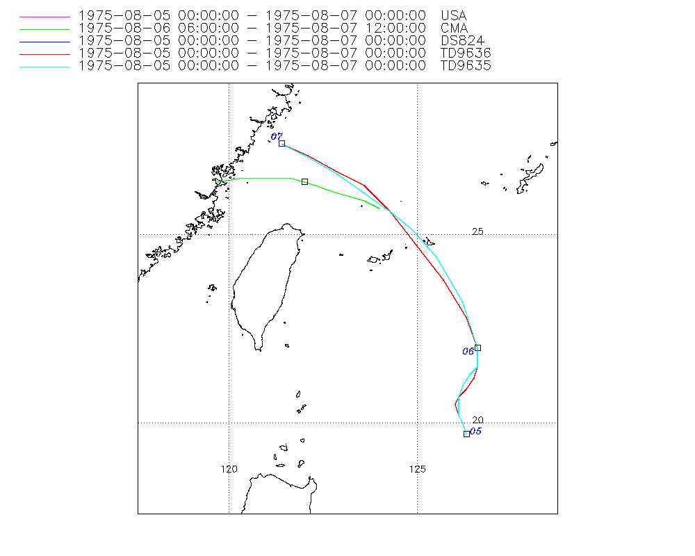
Storm track
-
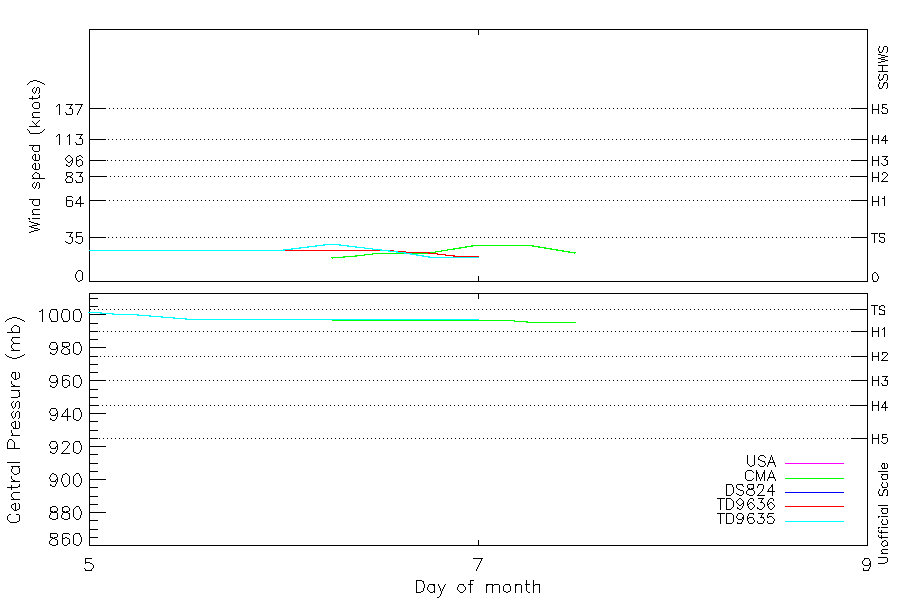
Intensity
-
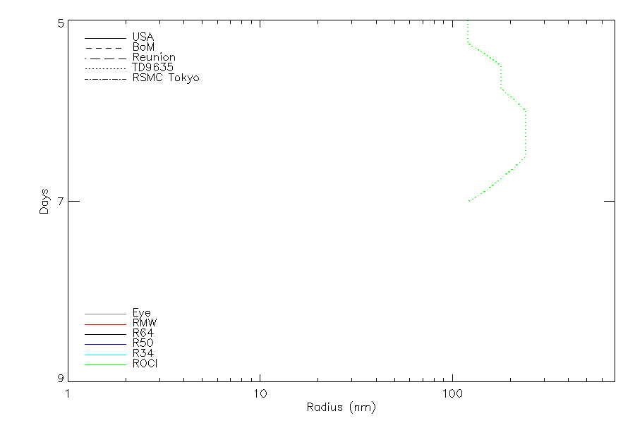
Wind Radii
-
Intensity Data
-
Source Data
-
All data
Summary Information
|
|
| Storm ID |
1975217N20126 |
| Start |
Aug 5 00Z |
| Max Intensity |
30 kt (Aug 6 06Z), 996 mb (Aug 7 06Z) |
| End |
Aug 7 12Z |
| ATCF IDs |
,WP051975 |
| Track status |
Best track data. |
|
Storm track plot
|
Intensity plots
|
Radial wind information
|
Position and Intensity Table
| BASIN |
ISO_TIME_________ |
NATURE |
LAT |
LON |
USA WIND |
CMA WIND |
CMA PRES |
DS824 WIND |
TD9636 WIND |
TD9635 WIND |
TD9635 PRES |
| |
|
|
degrees north |
degrees east |
kts |
kts |
mb |
kts |
kts |
kts |
mb |
| WP |
1975-08-05 00:00:00 |
TS |
19.70 |
126.30 |
25 |
|
|
25 |
25 |
25 |
1002 |
| WP |
03:00:00 |
TS |
20.00 |
126.20 |
25 |
|
|
25 |
25 |
25 |
1001 |
| WP |
06:00:00 |
TS |
20.20 |
126.10 |
25 |
|
|
25 |
25 |
25 |
1000 |
| WP |
09:00:00 |
TS |
20.50 |
126.10 |
25 |
|
|
25 |
25 |
25 |
999 |
| WP |
12:00:00 |
TS |
20.70 |
126.10 |
25 |
|
|
25 |
25 |
25 |
998 |
| WP |
15:00:00 |
TS |
21.00 |
126.20 |
25 |
|
|
25 |
25 |
25 |
998 |
| WP |
18:00:00 |
TS |
21.30 |
126.40 |
25 |
|
|
25 |
25 |
25 |
998 |
| WP |
21:00:00 |
TS |
21.50 |
126.60 |
25 |
|
|
25 |
25 |
25 |
998 |
| WP |
1975-08-06 00:00:00 |
TS |
22.00 |
126.60 |
25 |
|
|
25 |
25 |
25 |
998 |
| WP |
03:00:00 |
TS |
23.10 |
126.20 |
28 |
|
|
28 |
25 |
28 |
998 |
| WP |
06:00:00 |
MX |
24.30 |
125.50 |
30 |
19 |
997 |
30 |
25 |
30 |
998 |
| WP |
09:00:00 |
MX |
25.10 |
124.80 |
28 |
21 |
997 |
28 |
25 |
28 |
998 |
| WP |
12:00:00 |
TS |
25.70 |
124.10 |
25 |
23 |
997 |
25 |
25 |
25 |
998 |
| WP |
15:00:00 |
TS |
26.20 |
123.50 |
23 |
23 |
997 |
23 |
24 |
23 |
998 |
| WP |
18:00:00 |
TS |
26.50 |
122.80 |
20 |
23 |
997 |
20 |
23 |
20 |
998 |
| WP |
21:00:00 |
TS |
26.80 |
122.20 |
20 |
26 |
997 |
20 |
21 |
20 |
998 |
| WP |
1975-08-07 00:00:00 |
TS |
26.90 |
121.70 |
20 |
29 |
997 |
20 |
20 |
20 |
998 |
| WP |
03:00:00 |
TS |
26.50 |
121.60 |
|
29 |
997 |
|
|
|
|
| WP |
06:00:00 |
TS |
26.50 |
121.00 |
|
29 |
996 |
|
|
|
|
| WP |
09:00:00 |
TS |
26.50 |
120.40 |
|
26 |
996 |
|
|
|
|
| WP |
12:00:00 |
TS |
26.40 |
119.70 |
|
23 |
996 |
|
|
|
|
Source Information
| Agency |
Information |
| USA |
bwp051975.txt |
| TOKYO |
|
| CMA |
CH1975BST.txt:Storm=8:(nameless) |
| HKO |
|
| KMA |
|
| NEWDELHI |
|
| REUNION |
|
| BOM |
|
| NADI |
|
| WELLINGTON |
|
| DS824 |
w_npac.dat:842:05W |
| TD9636 |
cons_worldwide_trop_cyclone_18710101-19891231-003:Line=24720 |
| TD9635 |
typhoons-analogs_19450101-19761231.corrected:Line=19219 |
| NEUMANN |
|
| MLC |
|
All available IBTrACS Data
| SEASON |
BASIN |
SUBBASIN |
ISO_TIME_________ |
NATURE |
LAT |
LON |
DIST2LAND |
LANDFALL |
IFLAG |
USA AGENCY |
USA ATCF_ID |
USA LAT |
USA LON |
USA WIND |
USA SSHS |
CMA LAT |
CMA LON |
CMA CAT |
CMA WIND |
CMA PRES |
DS824 LAT |
DS824 LON |
DS824 STAGE |
DS824 WIND |
TD9636 LAT |
TD9636 LON |
TD9636 STAGE |
TD9636 WIND |
TD9635 LAT |
TD9635 LON |
TD9635 WIND |
TD9635 PRES |
TD9635 ROCI |
STORM SPEED |
STORM DIR |
| Year |
|
|
|
|
degrees north |
degrees east |
km |
km |
|
|
|
degrees north |
degrees east |
kts |
1 |
degrees north |
degrees east |
1 |
kts |
mb |
degrees north |
degrees east |
|
kts |
degrees north |
degrees east |
|
kts |
degrees north |
degrees east |
kts |
mb |
nmile |
kts |
degrees |
| 1975 |
WP |
MM |
1975-08-05 00:00:00 |
TS |
19.70 |
126.30 |
444 |
438 |
O_________OOO__ |
jtwc_wp |
WP051975 |
19.70 |
126.30 |
25 |
-1 |
|
|
|
|
|
19.70 |
126.30 |
TC |
25 |
19.70 |
126.30 |
1 |
25 |
19.70 |
126.30 |
25 |
1002 |
120 |
6 |
335 |
| 1975 |
WP |
MM |
03:00:00 |
TS |
20.00 |
126.20 |
446 |
437 |
P_________PPP__ |
|
WP051975 |
20.00 |
126.20 |
25 |
-1 |
|
|
|
|
|
20.00 |
126.20 |
TC |
25 |
20.00 |
126.20 |
1 |
25 |
20.00 |
126.20 |
25 |
1001 |
120 |
5 |
340 |
| 1975 |
WP |
MM |
06:00:00 |
TS |
20.20 |
126.10 |
446 |
446 |
O_________OPO__ |
jtwc_wp |
WP051975 |
20.20 |
126.10 |
25 |
-1 |
|
|
|
|
|
20.20 |
126.10 |
TC |
25 |
20.20 |
126.10 |
1 |
25 |
20.20 |
126.10 |
25 |
1000 |
120 |
5 |
345 |
| 1975 |
WP |
MM |
09:00:00 |
TS |
20.50 |
126.10 |
462 |
462 |
P_________PPP__ |
|
WP051975 |
20.40 |
126.10 |
25 |
-1 |
|
|
|
|
|
20.40 |
126.10 |
TC |
25 |
20.50 |
126.00 |
1 |
25 |
20.40 |
126.10 |
25 |
999 |
150 |
5 |
0 |
| 1975 |
WP |
MM |
12:00:00 |
TS |
20.70 |
126.10 |
474 |
474 |
O_________OOO__ |
jtwc_wp |
WP051975 |
20.70 |
126.10 |
25 |
-1 |
|
|
|
|
|
20.70 |
126.10 |
TC |
25 |
20.70 |
126.10 |
1 |
25 |
20.70 |
126.10 |
25 |
998 |
180 |
5 |
20 |
| 1975 |
WP |
MM |
15:00:00 |
TS |
21.00 |
126.20 |
501 |
501 |
P_________PPP__ |
|
WP051975 |
21.00 |
126.20 |
25 |
-1 |
|
|
|
|
|
21.00 |
126.20 |
TC |
25 |
20.90 |
126.30 |
1 |
25 |
21.00 |
126.20 |
25 |
998 |
180 |
6 |
30 |
| 1975 |
WP |
MM |
18:00:00 |
TS |
21.30 |
126.40 |
537 |
537 |
O_________OPO__ |
jtwc_wp |
WP051975 |
21.30 |
126.40 |
25 |
-1 |
|
|
|
|
|
21.30 |
126.40 |
TC |
25 |
21.20 |
126.50 |
1 |
25 |
21.30 |
126.40 |
25 |
998 |
180 |
6 |
30 |
| 1975 |
WP |
MM |
21:00:00 |
TS |
21.50 |
126.60 |
563 |
547 |
P_________PPP__ |
|
WP051975 |
21.50 |
126.60 |
25 |
-1 |
|
|
|
|
|
21.50 |
126.60 |
TC |
25 |
21.50 |
126.60 |
1 |
25 |
21.50 |
126.60 |
25 |
998 |
210 |
8 |
10 |
| 1975 |
WP |
MM |
1975-08-06 00:00:00 |
TS |
22.00 |
126.60 |
547 |
468 |
O_________OOO__ |
jtwc_wp |
WP051975 |
22.00 |
126.60 |
25 |
-1 |
|
|
|
|
|
22.00 |
126.60 |
TC |
25 |
22.00 |
126.60 |
1 |
25 |
22.00 |
126.60 |
25 |
998 |
240 |
16 |
345 |
| 1975 |
WP |
MM |
03:00:00 |
TS |
23.10 |
126.20 |
464 |
362 |
P_________PPP__ |
|
WP051975 |
23.20 |
126.20 |
28 |
-1 |
|
|
|
|
|
23.20 |
126.20 |
TC |
28 |
22.80 |
126.30 |
1 |
25 |
23.20 |
126.20 |
28 |
998 |
240 |
26 |
335 |
| 1975 |
WP |
MM |
06:00:00 |
MX |
24.30 |
125.50 |
362 |
282 |
O_O_______OPO__ |
jtwc_wp |
WP051975 |
24.40 |
125.50 |
30 |
-1 |
25.70 |
124.00 |
0 |
19 |
997 |
24.40 |
125.50 |
TC |
30 |
23.80 |
125.70 |
1 |
25 |
24.40 |
125.50 |
30 |
998 |
240 |
24 |
330 |
| 1975 |
WP |
MM |
09:00:00 |
MX |
25.10 |
124.80 |
282 |
230 |
P_P_______PPP__ |
|
WP051975 |
25.10 |
124.90 |
28 |
-1 |
25.90 |
123.60 |
0 |
21 |
997 |
25.10 |
124.90 |
TC |
28 |
24.70 |
125.00 |
1 |
25 |
25.10 |
124.90 |
28 |
998 |
240 |
18 |
320 |
| 1975 |
WP |
MM |
12:00:00 |
TS |
25.70 |
124.10 |
224 |
194 |
O_O_______OOO__ |
jtwc_wp |
WP051975 |
25.60 |
124.30 |
25 |
-1 |
26.00 |
123.20 |
1 |
23 |
997 |
25.60 |
124.30 |
TC |
25 |
25.60 |
124.30 |
1 |
25 |
25.60 |
124.30 |
25 |
998 |
240 |
16 |
310 |
| 1975 |
WP |
MM |
15:00:00 |
TS |
26.20 |
123.50 |
201 |
185 |
P_P_______PPP__ |
|
WP051975 |
26.10 |
123.60 |
23 |
-1 |
26.10 |
122.90 |
1 |
23 |
997 |
26.10 |
123.60 |
TC |
23 |
26.30 |
123.60 |
1 |
24 |
26.10 |
123.60 |
23 |
998 |
210 |
15 |
305 |
| 1975 |
WP |
MM |
18:00:00 |
TS |
26.50 |
122.80 |
185 |
167 |
O_O_______OPO__ |
jtwc_wp |
WP051975 |
26.60 |
122.90 |
20 |
-1 |
26.20 |
122.60 |
1 |
23 |
997 |
26.60 |
122.90 |
TC |
20 |
26.70 |
122.80 |
1 |
23 |
26.60 |
122.90 |
20 |
998 |
180 |
13 |
300 |
| 1975 |
WP |
MM |
21:00:00 |
TS |
26.80 |
122.20 |
167 |
119 |
P_P_______PPP__ |
|
WP051975 |
27.00 |
122.20 |
20 |
-1 |
26.30 |
122.30 |
1 |
26 |
997 |
27.00 |
122.20 |
TC |
20 |
27.10 |
122.10 |
1 |
21 |
27.00 |
122.20 |
20 |
998 |
150 |
11 |
290 |
| 1975 |
WP |
MM |
1975-08-07 00:00:00 |
TS |
26.90 |
121.70 |
119 |
117 |
O_O_______OOO__ |
jtwc_wp |
WP051975 |
27.40 |
121.40 |
20 |
-1 |
26.40 |
122.00 |
1 |
29 |
997 |
27.40 |
121.40 |
TC |
20 |
27.40 |
121.40 |
1 |
20 |
27.40 |
121.40 |
20 |
998 |
120 |
7 |
240 |
| 1975 |
WP |
MM |
03:00:00 |
TS |
26.50 |
121.60 |
134 |
89 |
__P____________ |
|
WP051975 |
|
|
|
-5 |
26.50 |
121.60 |
1 |
29 |
997 |
|
|
|
|
|
|
|
|
|
|
|
|
|
7 |
235 |
| 1975 |
WP |
MM |
06:00:00 |
TS |
26.50 |
121.00 |
89 |
31 |
__O____________ |
|
|
|
|
|
-5 |
26.50 |
121.00 |
1 |
29 |
996 |
|
|
|
|
|
|
|
|
|
|
|
|
|
11 |
270 |
| 1975 |
WP |
MM |
09:00:00 |
TS |
26.50 |
120.40 |
31 |
0 |
__P____________ |
|
|
|
|
|
-5 |
26.50 |
120.40 |
1 |
26 |
996 |
|
|
|
|
|
|
|
|
|
|
|
|
|
12 |
265 |
| 1975 |
WP |
MM |
12:00:00 |
TS |
26.40 |
119.70 |
9 |
|
__O____________ |
|
|
|
|
|
-5 |
26.40 |
119.70 |
1 |
23 |
996 |
|
|
|
|
|
|
|
|
|
|
|
|
|
12 |
265 |