1990
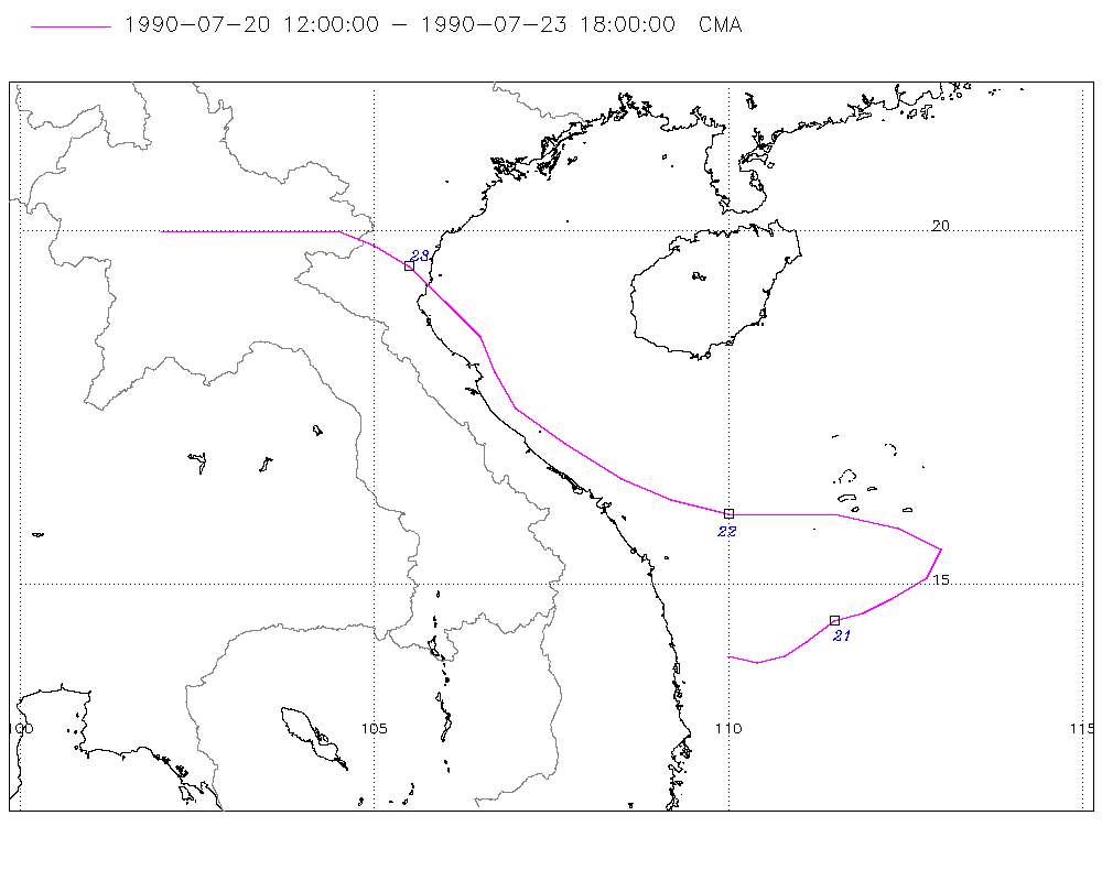
Tropical Depression UNNAMED (1990202N14110)
IBTrACS version v04r01. Visit
IBTrACS website for data access.
Please direct all questions to the
IBTrACS Q and A forum
Storm track
-
Intensity
-
Wind Radii
-
Intensity Data
-
Source Data
-
All data
Summary Information
|
|
| Storm ID |
1990202N14110 |
| Start |
Jul 20 12Z |
| Landfall |
Jul 23 00Z |
| Max Intensity |
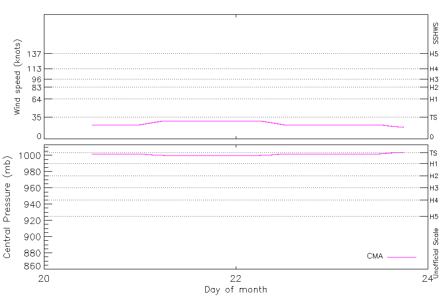
29 kt (Jul 21 06Z) |
| End |
Jul 23 18Z |
| ATCF IDs |
|
| Track status |
Best track data. |
|
Storm track plot
|
Intensity plots
|
Radial wind information
No radial wind information for this storm
|
Position and Intensity Table
Source Information
| Agency |
Information |
| USA |
|
| TOKYO |
|
| CMA |
CH1990BST.txt:Storm=11:(nameless) |
| HKO |
|
| KMA |
|
| NEWDELHI |
|
| REUNION |
|
| BOM |
|
| NADI |
|
| WELLINGTON |
|
| DS824 |
|
| TD9636 |
|
| TD9635 |
|
| NEUMANN |
|
| MLC |
|
All available IBTrACS Data
| SEASON |
BASIN |
SUBBASIN |
ISO_TIME_________ |
NATURE |
LAT |
LON |
DIST2LAND |
LANDFALL |
IFLAG |
USA SSHS |
CMA LAT |
CMA LON |
CMA CAT |
CMA WIND |
CMA PRES |
STORM SPEED |
STORM DIR |
| Year |
|
|
|
|
degrees north |
degrees east |
km |
km |
|
1 |
degrees north |
degrees east |
1 |
kts |
mb |
kts |
degrees |
| 1990 |
WP |
MM |
1990-07-20 12:00:00 |
TS |
14.00 |
110.00 |
76 |
76 |
__O____________ |
-5 |
14.00 |
110.00 |
1 |
23 |
1002 |
8 |
100 |
| 1990 |
WP |
MM |
15:00:00 |
TS |
13.90 |
110.40 |
118 |
118 |
__P____________ |
-5 |
13.90 |
110.40 |
1 |
23 |
1002 |
8 |
90 |
| 1990 |
WP |
MM |
18:00:00 |
TS |
14.00 |
110.80 |
162 |
162 |
__O____________ |
-5 |
14.00 |
110.80 |
1 |
23 |
1002 |
8 |
70 |
| 1990 |
WP |
MM |
21:00:00 |
TS |
14.20 |
111.10 |
197 |
197 |
__P____________ |
-5 |
14.20 |
111.10 |
1 |
23 |
1002 |
8 |
55 |
| 1990 |
WP |
MM |
1990-07-21 00:00:00 |
TS |
14.50 |
111.50 |
246 |
246 |
__O____________ |
-5 |
14.50 |
111.50 |
1 |
23 |
1002 |
8 |
60 |
| 1990 |
WP |
MM |
03:00:00 |
TS |
14.60 |
111.90 |
291 |
291 |
__P____________ |
-5 |
14.60 |
111.90 |
1 |
26 |
1001 |
8 |
70 |
| 1990 |
WP |
MM |
06:00:00 |
TS |
14.80 |
112.30 |
338 |
338 |
__O____________ |
-5 |
14.80 |
112.30 |
1 |
29 |
1000 |
10 |
60 |
| 1990 |
WP |
MM |
09:00:00 |
TS |
15.10 |
112.80 |
400 |
400 |
__P____________ |
-5 |
15.10 |
112.80 |
1 |
29 |
1000 |
10 |
45 |
| 1990 |
WP |
MM |
12:00:00 |
TS |
15.50 |
113.00 |
428 |
385 |
__O____________ |
-5 |
15.50 |
113.00 |
1 |
29 |
1000 |
8 |
330 |
| 1990 |
WP |
MM |
15:00:00 |
TS |
15.80 |
112.40 |
374 |
292 |
__P____________ |
-5 |
15.80 |
112.40 |
1 |
29 |
1000 |
15 |
290 |
| 1990 |
WP |
MM |
18:00:00 |
TS |
16.00 |
111.50 |
292 |
222 |
__O____________ |
-5 |
16.00 |
111.50 |
1 |
29 |
1000 |
16 |
275 |
| 1990 |
WP |
MM |
21:00:00 |
TS |
16.00 |
110.70 |
212 |
148 |
__P____________ |
-5 |
16.00 |
110.70 |
1 |
29 |
1000 |
14 |
270 |
| 1990 |
WP |
MM |
1990-07-22 00:00:00 |
TS |
16.00 |
110.00 |
148 |
100 |
__O____________ |
-5 |
16.00 |
110.00 |
1 |
29 |
1000 |
15 |
275 |
| 1990 |
WP |
MM |
03:00:00 |
TS |
16.20 |
109.20 |
96 |
54 |
__P____________ |
-5 |
16.20 |
109.20 |
1 |
29 |
1000 |
15 |
290 |
| 1990 |
WP |
MM |
06:00:00 |
TS |
16.50 |
108.50 |
54 |
35 |
__O____________ |
-5 |
16.50 |
108.50 |
1 |
29 |
1000 |
17 |
300 |
| 1990 |
WP |
MM |
09:00:00 |
TS |
17.00 |
107.70 |
46 |
24 |
__P____________ |
-5 |
17.00 |
107.70 |
1 |
26 |
1001 |
18 |
305 |
| 1990 |
WP |
MM |
12:00:00 |
TS |
17.50 |
107.00 |
30 |
21 |
__O____________ |
-5 |
17.50 |
107.00 |
1 |
23 |
1002 |
14 |
320 |
| 1990 |
WP |
MM |
15:00:00 |
TS |
18.00 |
106.70 |
23 |
23 |
__P____________ |
-5 |
18.00 |
106.70 |
1 |
23 |
1002 |
11 |
335 |
| 1990 |
WP |
MM |
18:00:00 |
TS |
18.50 |
106.50 |
39 |
39 |
__O____________ |
-5 |
18.50 |
106.50 |
1 |
23 |
1002 |
12 |
330 |
| 1990 |
WP |
MM |
21:00:00 |
TS |
19.00 |
106.00 |
33 |
0 |
__P____________ |
-5 |
19.00 |
106.00 |
1 |
23 |
1002 |
14 |
315 |
| 1990 |
WP |
MM |
1990-07-23 00:00:00 |
TS |
19.50 |
105.50 |
0 |
0 |
__O____________ |
-5 |
19.50 |
105.50 |
1 |
23 |
1002 |
12 |
310 |
| 1990 |
WP |
MM |
03:00:00 |
TS |
19.80 |
105.00 |
0 |
0 |
__P____________ |
-5 |
19.80 |
105.00 |
1 |
23 |
1002 |
11 |
300 |
| 1990 |
WP |
MM |
06:00:00 |
TS |
20.00 |
104.50 |
0 |
0 |
__O____________ |
-5 |
20.00 |
104.50 |
1 |
23 |
1002 |
12 |
280 |
| 1990 |
WP |
MM |
09:00:00 |
TS |
20.00 |
103.70 |
0 |
0 |
__P____________ |
-5 |
20.00 |
103.70 |
1 |
23 |
1002 |
14 |
270 |
| 1990 |
WP |
MM |
12:00:00 |
TS |
20.00 |
103.00 |
0 |
0 |
__O____________ |
-5 |
20.00 |
103.00 |
1 |
23 |
1002 |
12 |
270 |
| 1990 |
WP |
MM |
15:00:00 |
TS |
20.00 |
102.40 |
0 |
0 |
__P____________ |
-5 |
20.00 |
102.40 |
1 |
21 |
1003 |
9 |
270 |
| 1990 |
WP |
MM |
18:00:00 |
DS |
20.00 |
102.00 |
0 |
|
__O____________ |
-5 |
20.00 |
102.00 |
0 |
19 |
1004 |
8 |
270 |