2002
Tropical Cyclone (Gale) UNNAMED (2002015S20159)
IBTrACS version v04r01. Visit
IBTrACS website for data access.
Please direct all questions to the
IBTrACS Q and A forum
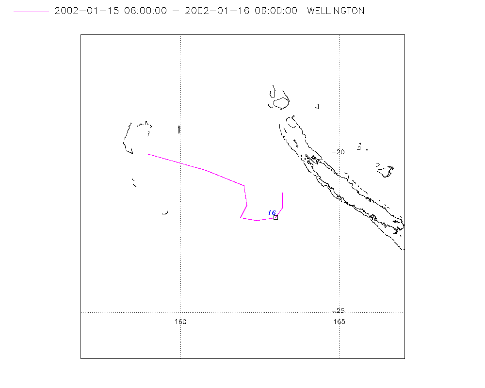
Storm track
-
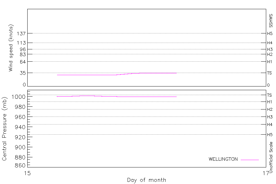
Intensity
-
Wind Radii
-
Intensity Data
-
Source Data
-
All data
Summary Information
|
| Storm ID |
2002015S20159 |
| Start |
Jan 15 06Z |
| Max Intensity |
35 kt (Jan 16 00Z) |
| End |
Jan 16 06Z |
| ATCF IDs |
|
| Track status |
Best track data. |
|
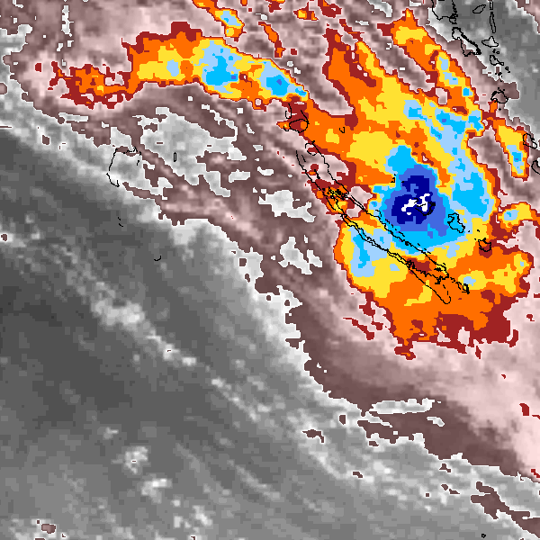
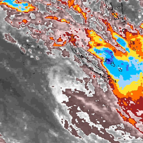
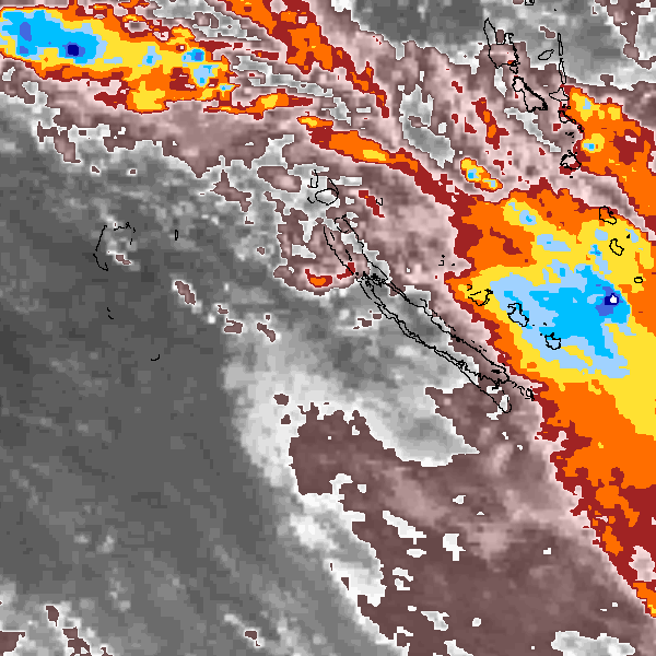
Storm track plot
|
Intensity plots
|
Radial wind information
No radial wind information for this storm
|
Position and Intensity Table
Source Information
| Agency |
Information |
| USA |
|
| TOKYO |
|
| CMA |
|
| HKO |
|
| KMA |
|
| NEWDELHI |
|
| REUNION |
|
| BOM |
|
| NADI |
|
| WELLINGTON |
TC_BT_1967_2006.csv:Line=7050:06F |
| DS824 |
|
| TD9636 |
|
| TD9635 |
|
| NEUMANN |
|
| MLC |
|
All available IBTrACS Data
| SEASON |
BASIN |
SUBBASIN |
ISO_TIME_________ |
NATURE |
LAT |
LON |
DIST2LAND |
LANDFALL |
IFLAG |
USA SSHS |
WELLINGTON LAT |
WELLINGTON LON |
WELLINGTON WIND |
WELLINGTON PRES |
STORM SPEED |
STORM DIR |
| Year |
|
|
|
|
degrees north |
degrees east |
km |
km |
|
1 |
degrees north |
degrees east |
kts |
mb |
kts |
degrees |
| 2002 |
SP |
EA |
2002-01-15 06:00:00 |
NR |
-20.00 |
159.00 |
522 |
344 |
_________O_____ |
-5 |
-20.00 |
159.00 |
30 |
1000 |
36 |
105 |
| 2002 |
SP |
MM |
09:00:00 |
NR |
-20.50 |
160.80 |
334 |
222 |
_________P_____ |
-5 |
-20.50 |
160.80 |
30 |
1001 |
30 |
110 |
| 2002 |
SP |
MM |
12:00:00 |
NR |
-21.00 |
162.00 |
222 |
216 |
_________O_____ |
-5 |
-21.00 |
162.00 |
30 |
1002 |
16 |
135 |
| 2002 |
SP |
MM |
15:00:00 |
NR |
-21.60 |
162.10 |
245 |
245 |
_________P_____ |
-5 |
-21.60 |
162.10 |
30 |
1001 |
10 |
185 |
| 2002 |
SP |
MM |
18:00:00 |
NR |
-22.00 |
161.90 |
289 |
252 |
_________O_____ |
-5 |
-22.00 |
161.90 |
30 |
1000 |
6 |
150 |
| 2002 |
SP |
MM |
21:00:00 |
NR |
-22.10 |
162.40 |
252 |
197 |
_________P_____ |
-5 |
-22.10 |
162.40 |
33 |
1000 |
10 |
90 |
| 2002 |
SP |
MM |
2002-01-16 00:00:00 |
NR |
-22.00 |
163.00 |
197 |
159 |
_________O_____ |
-5 |
-22.00 |
163.00 |
35 |
1000 |
9 |
55 |
| 2002 |
SP |
MM |
03:00:00 |
NR |
-21.70 |
163.20 |
159 |
129 |
_________P_____ |
-5 |
-21.70 |
163.20 |
35 |
1000 |
8 |
15 |
| 2002 |
SP |
MM |
06:00:00 |
NR |
-21.20 |
163.20 |
129 |
|
_________O_____ |
-5 |
-21.20 |
163.20 |
35 |
1000 |
9 |
360 |