2002
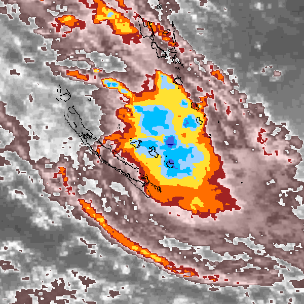
Tropical Cyclone (Gale) UNNAMED (2002073S16161)
IBTrACS version v04r01. Visit
IBTrACS website for data access.
Please direct all questions to the
IBTrACS Q and A forum
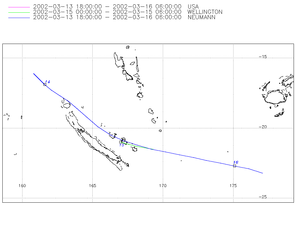
Storm track
-
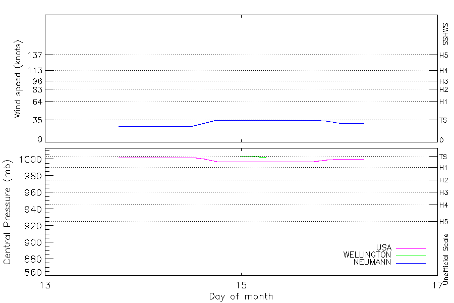
Intensity
-
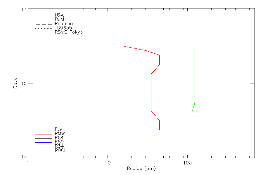
Wind Radii
-
Intensity Data
-
Source Data
-
All data
Summary Information
|
| Storm ID |
2002073S16161 |
| Start |
Mar 13 18Z |
| Max Intensity |
35 kt (Mar 14 18Z), 997 mb (Mar 14 18Z) |
| End |
Mar 16 06Z |
| ATCF IDs |
SH192002 |
| Track status |
Best track data. |
|
Storm track plot
|
Intensity plots
|
Radial wind information
|
Position and Intensity Table
Source Information
| Agency |
Information |
| USA |
bsh192002.txt |
| TOKYO |
|
| CMA |
|
| HKO |
|
| KMA |
|
| NEWDELHI |
|
| REUNION |
|
| BOM |
|
| NADI |
|
| WELLINGTON |
TC_BT_1967_2006.csv:Line=7101:13F |
| DS824 |
|
| TD9636 |
|
| TD9635 |
|
| NEUMANN |
tracks.sh:Storm=1244:TC 19P:BSH192002:JTWC |
| MLC |
|
All available IBTrACS Data
| SEASON |
BASIN |
SUBBASIN |
ISO_TIME_________ |
NATURE |
LAT |
LON |
DIST2LAND |
LANDFALL |
IFLAG |
USA AGENCY |
USA ATCF_ID |
USA LAT |
USA LON |
USA STATUS |
USA WIND |
USA PRES |
USA SSHS |
USA POCI |
USA ROCI |
USA RMW |
WELLINGTON LAT |
WELLINGTON LON |
WELLINGTON WIND |
WELLINGTON PRES |
NEUMANN LAT |
NEUMANN LON |
NEUMANN CLASS |
NEUMANN WIND |
STORM SPEED |
STORM DIR |
| Year |
|
|
|
|
degrees north |
degrees east |
km |
km |
|
|
|
degrees north |
degrees east |
|
kts |
mb |
1 |
mb |
nmile |
nmile |
degrees north |
degrees east |
kts |
mb |
degrees north |
degrees east |
|
kts |
kts |
degrees |
| 2002 |
SP |
MM |
2002-03-13 18:00:00 |
TS |
-16.10 |
160.80 |
576 |
514 |
O____________O_ |
jtwc_sh |
SH192002 |
-16.10 |
160.80 |
TD |
25 |
1002 |
-1 |
|
|
|
|
|
|
|
-16.10 |
160.80 |
TC |
25 |
11 |
140 |
| 2002 |
SP |
MM |
21:00:00 |
TS |
-16.50 |
161.20 |
514 |
453 |
P____________P_ |
|
SH192002 |
-16.50 |
161.20 |
TD |
25 |
1002 |
-1 |
|
|
|
|
|
|
|
-16.50 |
161.20 |
TC |
25 |
11 |
135 |
| 2002 |
SP |
MM |
2002-03-14 00:00:00 |
TS |
-16.90 |
161.60 |
453 |
386 |
O____________O_ |
jtwc_sh |
SH192002 |
-16.90 |
161.60 |
TD |
25 |
1002 |
-1 |
1008 |
125 |
15 |
|
|
|
|
-16.90 |
161.60 |
TC |
25 |
12 |
130 |
| 2002 |
SP |
MM |
03:00:00 |
TS |
-17.30 |
162.10 |
386 |
316 |
P____________P_ |
|
SH192002 |
-17.30 |
162.10 |
TD |
25 |
1002 |
-1 |
1008 |
125 |
30 |
|
|
|
|
-17.30 |
162.10 |
TC |
25 |
13 |
125 |
| 2002 |
SP |
MM |
06:00:00 |
TS |
-17.70 |
162.70 |
316 |
253 |
O____________O_ |
jtwc_sh |
SH192002 |
-17.70 |
162.70 |
TD |
25 |
1002 |
-1 |
1007 |
125 |
45 |
|
|
|
|
-17.70 |
162.70 |
TC |
25 |
14 |
125 |
| 2002 |
SP |
MM |
09:00:00 |
TS |
-18.10 |
163.30 |
249 |
180 |
P____________P_ |
|
SH192002 |
-18.10 |
163.30 |
TD |
25 |
1002 |
-1 |
1007 |
125 |
45 |
|
|
|
|
-18.10 |
163.30 |
TC |
25 |
15 |
130 |
| 2002 |
SP |
MM |
12:00:00 |
TS |
-18.60 |
163.90 |
180 |
119 |
O____________O_ |
jtwc_sh |
SH192002 |
-18.60 |
163.90 |
TD |
25 |
1002 |
-1 |
1007 |
125 |
45 |
|
|
|
|
-18.60 |
163.90 |
TC |
25 |
17 |
130 |
| 2002 |
SP |
MM |
15:00:00 |
TS |
-19.20 |
164.60 |
123 |
91 |
P____________P_ |
|
SH192002 |
-19.20 |
164.60 |
TD |
30 |
1000 |
-1 |
1007 |
125 |
40 |
|
|
|
|
-19.20 |
164.60 |
TC |
30 |
19 |
135 |
| 2002 |
SP |
MM |
18:00:00 |
TS |
-19.90 |
165.40 |
99 |
88 |
O____________O_ |
jtwc_sh |
SH192002 |
-19.90 |
165.40 |
TS |
35 |
997 |
0 |
1007 |
125 |
35 |
|
|
|
|
-19.90 |
165.40 |
TC |
35 |
20 |
130 |
| 2002 |
SP |
MM |
21:00:00 |
TS |
-20.50 |
166.30 |
106 |
106 |
P____________P_ |
|
SH192002 |
-20.50 |
166.30 |
TS |
35 |
997 |
0 |
|
|
|
|
|
|
|
-20.50 |
166.30 |
TC |
35 |
20 |
120 |
| 2002 |
SP |
MM |
2002-03-15 00:00:00 |
TS |
-20.90 |
167.20 |
121 |
121 |
O________O___O_ |
jtwc_sh |
SH192002 |
-20.90 |
167.20 |
TS |
35 |
997 |
0 |
|
|
|
-21.00 |
167.00 |
35 |
1004 |
-20.90 |
167.20 |
TC |
35 |
20 |
115 |
| 2002 |
SP |
MM |
03:00:00 |
TS |
-21.20 |
168.20 |
166 |
159 |
P________P___P_ |
|
SH192002 |
-21.20 |
168.20 |
TS |
35 |
997 |
0 |
|
|
|
-21.30 |
168.10 |
35 |
1003 |
-21.20 |
168.20 |
TC |
35 |
20 |
105 |
| 2002 |
SP |
MM |
06:00:00 |
TS |
-21.50 |
169.20 |
240 |
240 |
O________O___O_ |
jtwc_sh |
SH192002 |
-21.50 |
169.20 |
TS |
35 |
997 |
0 |
1007 |
125 |
35 |
-21.50 |
169.30 |
35 |
1002 |
-21.50 |
169.20 |
TC |
35 |
19 |
105 |
| 2002 |
SP |
MM |
09:00:00 |
TS |
-21.70 |
170.20 |
334 |
334 |
P____________P_ |
|
SH192002 |
-21.70 |
170.20 |
TS |
35 |
997 |
0 |
1007 |
125 |
35 |
|
|
|
|
-21.70 |
170.20 |
TC |
35 |
19 |
100 |
| 2002 |
SP |
MM |
12:00:00 |
TS |
-21.90 |
171.20 |
434 |
434 |
O____________O_ |
jtwc_sh |
SH192002 |
-21.90 |
171.20 |
TS |
35 |
997 |
0 |
1007 |
125 |
35 |
|
|
|
|
-21.90 |
171.20 |
TC |
35 |
18 |
100 |
| 2002 |
SP |
MM |
15:00:00 |
TS |
-22.10 |
172.20 |
535 |
535 |
P____________P_ |
|
SH192002 |
-22.10 |
172.20 |
TS |
35 |
997 |
0 |
1007 |
120 |
35 |
|
|
|
|
-22.10 |
172.20 |
TC |
35 |
18 |
105 |
| 2002 |
SP |
MM |
18:00:00 |
TS |
-22.30 |
173.10 |
627 |
597 |
O____________O_ |
jtwc_sh |
SH192002 |
-22.30 |
173.10 |
TS |
35 |
997 |
0 |
1006 |
115 |
35 |
|
|
|
|
-22.30 |
173.10 |
TC |
35 |
18 |
100 |
| 2002 |
SP |
MM |
21:00:00 |
TS |
-22.50 |
174.10 |
594 |
566 |
P____________P_ |
|
SH192002 |
-22.50 |
174.10 |
TS |
33 |
999 |
-1 |
1006 |
115 |
40 |
|
|
|
|
-22.50 |
174.10 |
TC |
33 |
19 |
100 |
| 2002 |
SP |
MM |
2002-03-16 00:00:00 |
TS |
-22.70 |
175.10 |
563 |
551 |
O____________O_ |
jtwc_sh |
SH192002 |
-22.70 |
175.10 |
TD |
30 |
1000 |
-1 |
1006 |
115 |
45 |
|
|
|
|
-22.70 |
175.10 |
TC |
30 |
19 |
105 |
| 2002 |
SP |
MM |
03:00:00 |
TS |
-22.90 |
176.10 |
547 |
545 |
P____________P_ |
|
SH192002 |
-22.90 |
176.10 |
TD |
30 |
1000 |
-1 |
1006 |
115 |
45 |
|
|
|
|
-22.90 |
176.10 |
TC |
30 |
19 |
105 |
| 2002 |
SP |
MM |
06:00:00 |
TS |
-23.20 |
177.10 |
554 |
|
O____________O_ |
jtwc_sh |
SH192002 |
-23.20 |
177.10 |
TD |
30 |
1000 |
-1 |
1006 |
115 |
45 |
|
|
|
|
-23.20 |
177.10 |
TC |
30 |
19 |
105 |