2025
Tropical Cyclone (Storm) TAM (2025104S15168)
IBTrACS version v04r01. Visit
IBTrACS website for data access.
Please direct all questions to the
IBTrACS Q and A forum
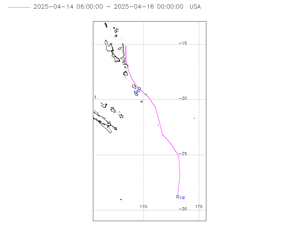
Storm track
-
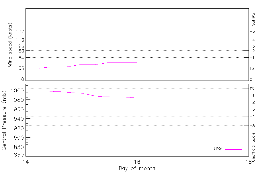
Intensity
-
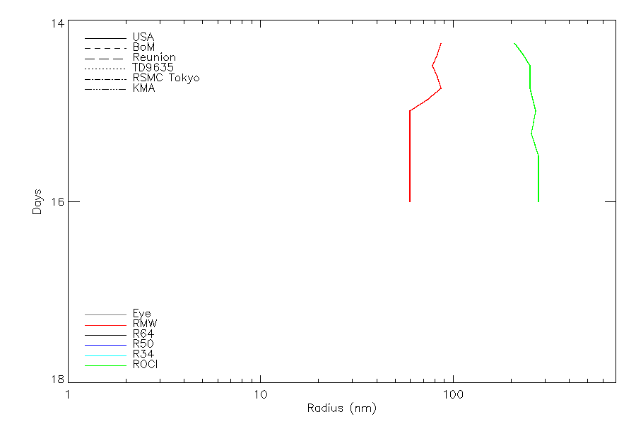
Wind Radii
-
Intensity Data
-
Source Data
-
All data
Summary Information
|
|
| Storm ID |
2025104S15168 |
| Start |
Apr 14 06Z |
| Max Intensity |
51 kt (Apr 15 12Z), 977 mb (Apr 16 18Z) |
| End |
Apr 19 00Z |
| ATCF IDs |
,SH302025 |
| Track status |
US-PROVISIONAL. US track from operational data. Other sources are best track. US sources will be upgraded to 'best track' quality after reanalysis |
|
Storm track plot
|
Intensity plots
|
Radial wind information
|
Position and Intensity Table
| BASIN |
ISO_TIME_________ |
NATURE |
LAT |
LON |
WMO WIND |
WMO PRES |
USA WIND |
USA PRES |
NADI WIND |
NADI PRES |
WELLINGTON WIND |
WELLINGTON PRES |
| |
|
|
degrees north |
degrees east |
kts |
mb |
kts |
mb |
kts |
mb |
kts |
mb |
| SP |
2025-04-14 06:00:00 |
NR |
-15.10 |
168.40 |
20 |
1000 |
35 |
999 |
20 |
1000 |
|
|
| SP |
09:00:00 |
NR |
-15.70 |
168.30 |
|
|
37 |
999 |
20 |
999 |
|
|
| SP |
12:00:00 |
NR |
-16.40 |
168.30 |
20 |
998 |
39 |
998 |
20 |
998 |
|
|
| SP |
15:00:00 |
NR |
-17.20 |
168.50 |
|
|
39 |
997 |
25 |
997 |
|
|
| SP |
18:00:00 |
NR |
-18.00 |
168.90 |
30 |
996 |
39 |
996 |
30 |
996 |
|
|
| SP |
21:00:00 |
NR |
-18.60 |
169.30 |
|
|
42 |
995 |
30 |
996 |
|
|
| SP |
2025-04-15 00:00:00 |
NR |
-19.10 |
169.80 |
30 |
996 |
45 |
994 |
30 |
996 |
|
|
| SP |
03:00:00 |
NR |
-19.80 |
170.40 |
|
|
45 |
991 |
35 |
992 |
|
|
| SP |
06:00:00 |
TS |
-20.80 |
170.90 |
40 |
987 |
45 |
988 |
40 |
987 |
|
|
| SP |
09:00:00 |
TS |
-22.00 |
171.10 |
|
|
48 |
987 |
43 |
987 |
|
|
| SP |
12:00:00 |
TS |
-23.20 |
171.50 |
45 |
986 |
51 |
986 |
45 |
986 |
|
|
| SP |
15:00:00 |
TS |
-24.00 |
172.40 |
40 |
987 |
51 |
986 |
40 |
987 |
|
|
| SP |
18:00:00 |
TS |
-25.20 |
173.10 |
40 |
990 |
51 |
986 |
40 |
988 |
40 |
990 |
| SP |
21:00:00 |
NR |
-27.00 |
173.10 |
|
|
51 |
985 |
|
|
20 |
990 |
| SP |
2025-04-16 00:00:00 |
NR |
-28.70 |
173.00 |
|
990 |
51 |
984 |
|
|
|
990 |
| SP |
03:00:00 |
NR |
-29.90 |
172.60 |
|
|
|
|
|
|
|
991 |
| SP |
06:00:00 |
NR |
-31.00 |
171.70 |
|
991 |
|
|
|
|
|
991 |
| SP |
09:00:00 |
NR |
-32.40 |
170.50 |
|
|
|
|
|
|
|
992 |
| SP |
12:00:00 |
NR |
-33.40 |
169.10 |
|
992 |
|
|
|
|
|
992 |
| SP |
15:00:00 |
NR |
-33.00 |
167.70 |
|
|
|
|
|
|
|
985 |
| SP |
18:00:00 |
NR |
-32.40 |
166.60 |
|
977 |
|
|
|
|
|
977 |
| SP |
21:00:00 |
NR |
-33.10 |
166.00 |
|
|
|
|
|
|
|
978 |
| SP |
2025-04-17 00:00:00 |
NR |
-34.10 |
165.80 |
|
978 |
|
|
|
|
|
978 |
| SP |
03:00:00 |
NR |
-34.60 |
165.60 |
|
|
|
|
|
|
|
979 |
| SP |
06:00:00 |
NR |
-35.00 |
165.50 |
|
979 |
|
|
|
|
|
979 |
| SP |
09:00:00 |
NR |
-35.40 |
165.40 |
|
|
|
|
|
|
|
980 |
| SP |
12:00:00 |
NR |
-35.70 |
165.30 |
|
980 |
|
|
|
|
|
980 |
| SP |
15:00:00 |
NR |
-36.00 |
165.30 |
|
|
|
|
|
|
|
981 |
| SP |
18:00:00 |
NR |
-36.30 |
165.30 |
|
981 |
|
|
|
|
|
981 |
| SP |
21:00:00 |
NR |
-36.60 |
165.40 |
|
|
|
|
|
|
|
981 |
| SP |
2025-04-18 00:00:00 |
NR |
-37.00 |
165.50 |
|
981 |
|
|
|
|
|
981 |
| SP |
03:00:00 |
NR |
-37.50 |
165.60 |
|
|
|
|
|
|
|
982 |
| SP |
06:00:00 |
NR |
-37.90 |
165.60 |
|
982 |
|
|
|
|
|
982 |
| SP |
09:00:00 |
NR |
-38.20 |
165.40 |
|
|
|
|
|
|
|
982 |
| SP |
12:00:00 |
NR |
-38.40 |
165.40 |
|
982 |
|
|
|
|
|
982 |
| SP |
15:00:00 |
NR |
-38.50 |
165.80 |
|
|
|
|
|
|
|
983 |
| SP |
18:00:00 |
NR |
-38.50 |
166.40 |
|
983 |
|
|
|
|
|
983 |
| SP |
21:00:00 |
NR |
-38.60 |
166.90 |
|
|
|
|
|
|
|
984 |
| SP |
2025-04-19 00:00:00 |
NR |
-38.80 |
167.40 |
|
984 |
|
|
|
|
|
984 |
Source Information
| Agency |
Information |
| USA |
BOTH_tcvitals.txt:Line=20595 |
| TOKYO |
|
| CMA |
|
| HKO |
|
| KMA |
|
| NEWDELHI |
|
| REUNION |
|
| BOM |
|
| NADI |
Post_event_Best_Track_2425_11F_TAM.csv:Line=6:Tam |
| WELLINGTON |
TC_BT_2006-current.csv:Line=1164:TAM |
| DS824 |
|
| TD9636 |
|
| TD9635 |
|
| NEUMANN |
|
| MLC |
|
All available IBTrACS Data
| SEASON |
BASIN |
SUBBASIN |
ISO_TIME_________ |
NATURE |
LAT |
LON |
WMO WIND |
WMO PRES |
WMO AGENCY |
DIST2LAND |
LANDFALL |
IFLAG |
USA AGENCY |
USA ATCF_ID |
USA LAT |
USA LON |
USA WIND |
USA PRES |
USA SSHS |
USA R34 |
USA POCI |
USA ROCI |
USA RMW |
NADI LAT |
NADI LON |
NADI CAT |
NADI WIND |
NADI PRES |
WELLINGTON LAT |
WELLINGTON LON |
WELLINGTON WIND |
WELLINGTON PRES |
STORM SPEED |
STORM DIR |
| Year |
|
|
|
|
degrees north |
degrees east |
kts |
mb |
|
km |
km |
|
|
|
degrees north |
degrees east |
kts |
mb |
1 |
nmile |
mb |
nmile |
nmile |
degrees north |
degrees east |
1 |
kts |
mb |
degrees north |
degrees east |
kts |
mb |
kts |
degrees |
| 2025 |
SP |
MM |
2025-04-14 06:00:00 |
NR |
-15.10 |
168.40 |
20 |
1000 |
nadi |
136 |
85 |
O_______O______ |
tcvitals |
SH302025 |
-15.10 |
168.40 |
35 |
999 |
0 |
|
1004 |
240 |
100 |
-15.20 |
168.30 |
|
20 |
1000 |
|
|
|
|
11 |
190 |
| 2025 |
SP |
MM |
09:00:00 |
NR |
-15.70 |
168.30 |
|
|
|
85 |
44 |
P_______P______ |
|
SH302025 |
-15.70 |
168.40 |
37 |
999 |
0 |
|
1005 |
265 |
95 |
-15.70 |
168.00 |
|
20 |
999 |
|
|
|
|
12 |
185 |
| 2025 |
SP |
MM |
12:00:00 |
NR |
-16.40 |
168.30 |
20 |
998 |
nadi |
53 |
53 |
O_______O______ |
tcvitals |
SH302025 |
-16.40 |
168.40 |
39 |
998 |
0 |
|
1006 |
290 |
90 |
-16.30 |
168.00 |
|
20 |
998 |
|
|
|
|
16 |
170 |
| 2025 |
SP |
MM |
15:00:00 |
NR |
-17.20 |
168.50 |
|
|
|
100 |
100 |
P_______P______ |
|
SH302025 |
-17.20 |
168.60 |
39 |
997 |
0 |
|
1006 |
290 |
95 |
-17.20 |
168.30 |
|
25 |
997 |
|
|
|
|
18 |
160 |
| 2025 |
SP |
MM |
18:00:00 |
NR |
-18.00 |
168.90 |
30 |
996 |
nadi |
195 |
195 |
O_______O______ |
tcvitals |
SH302025 |
-18.00 |
168.90 |
39 |
996 |
0 |
225,85,45,130 |
1006 |
290 |
100 |
-18.10 |
168.90 |
|
30 |
996 |
|
|
|
|
16 |
150 |
| 2025 |
SP |
MM |
21:00:00 |
NR |
-18.60 |
169.30 |
|
|
|
274 |
274 |
P_______P______ |
|
SH302025 |
-18.50 |
169.20 |
42 |
995 |
0 |
|
1005 |
300 |
85 |
-18.70 |
169.70 |
|
30 |
996 |
|
|
|
|
14 |
140 |
| 2025 |
SP |
MM |
2025-04-15 00:00:00 |
NR |
-19.10 |
169.80 |
30 |
996 |
nadi |
350 |
350 |
O_______O______ |
tcvitals |
SH302025 |
-19.00 |
169.60 |
45 |
994 |
0 |
|
1004 |
310 |
70 |
-19.30 |
170.30 |
|
30 |
996 |
|
|
|
|
16 |
140 |
| 2025 |
SP |
MM |
03:00:00 |
NR |
-19.80 |
170.40 |
|
|
|
443 |
432 |
P_______P______ |
|
SH302025 |
-19.70 |
170.40 |
45 |
991 |
0 |
|
1003 |
303 |
70 |
-20.00 |
170.50 |
|
35 |
992 |
|
|
|
|
20 |
150 |
| 2025 |
SP |
MM |
06:00:00 |
TS |
-20.80 |
170.90 |
40 |
987 |
nadi |
432 |
417 |
O_______O______ |
tcvitals |
SH302025 |
-20.70 |
171.10 |
45 |
988 |
0 |
|
1002 |
295 |
70 |
-20.90 |
170.50 |
1 |
40 |
987 |
|
|
|
|
22 |
165 |
| 2025 |
SP |
MM |
09:00:00 |
TS |
-22.00 |
171.10 |
|
|
|
422 |
421 |
P_______P______ |
|
SH302025 |
-21.90 |
171.40 |
48 |
987 |
0 |
|
1003 |
308 |
70 |
-22.10 |
170.50 |
1 |
43 |
987 |
|
|
|
|
25 |
165 |
| 2025 |
SP |
MM |
12:00:00 |
TS |
-23.20 |
171.50 |
45 |
986 |
nadi |
472 |
472 |
O_______O______ |
tcvitals |
SH302025 |
-23.10 |
171.70 |
51 |
986 |
0 |
|
1004 |
320 |
70 |
-23.30 |
170.90 |
1 |
45 |
986 |
|
|
|
|
24 |
150 |
| 2025 |
SP |
MM |
15:00:00 |
TS |
-24.00 |
172.40 |
40 |
987 |
nadi |
583 |
583 |
P_______O______ |
|
SH302025 |
-24.00 |
172.50 |
51 |
986 |
0 |
|
1004 |
320 |
70 |
-24.00 |
172.00 |
1 |
40 |
987 |
|
|
|
|
25 |
145 |
| 2025 |
SP |
MM |
18:00:00 |
TS |
-25.20 |
173.10 |
40 |
990 |
wellington |
699 |
699 |
O_______OO_____ |
tcvitals |
SH302025 |
-25.10 |
173.20 |
51 |
986 |
0 |
|
1004 |
320 |
70 |
-25.10 |
173.10 |
1 |
40 |
988 |
-25.90 |
172.20 |
40 |
990 |
31 |
165 |
| 2025 |
SP |
MM |
21:00:00 |
NR |
-27.00 |
173.10 |
|
|
|
809 |
647 |
P________P_____ |
|
SH302025 |
-26.80 |
173.30 |
51 |
985 |
0 |
|
1004 |
320 |
70 |
|
|
|
|
|
-27.40 |
172.80 |
20 |
990 |
36 |
180 |
| 2025 |
SP |
MM |
2025-04-16 00:00:00 |
NR |
-28.70 |
173.00 |
|
990 |
wellington |
646 |
524 |
O________O_____ |
tcvitals |
SH302025 |
-28.80 |
173.10 |
51 |
984 |
0 |
|
1004 |
320 |
70 |
|
|
|
|
|
-28.70 |
173.00 |
-1 |
990 |
30 |
190 |
| 2025 |
SP |
MM |
03:00:00 |
NR |
-29.90 |
172.60 |
|
|
|
513 |
408 |
_________P_____ |
|
SH302025 |
|
|
|
|
-5 |
|
|
|
|
|
|
|
|
|
-29.90 |
172.60 |
-1 |
991 |
25 |
205 |
| 2025 |
SP |
MM |
06:00:00 |
NR |
-31.00 |
171.70 |
|
991 |
wellington |
399 |
298 |
_________O_____ |
|
|
|
|
|
|
-5 |
|
|
|
|
|
|
|
|
|
-31.00 |
171.70 |
-1 |
991 |
31 |
215 |
| 2025 |
SP |
MM |
09:00:00 |
NR |
-32.40 |
170.50 |
|
|
|
304 |
291 |
_________P_____ |
|
|
|
|
|
|
-5 |
|
|
|
|
|
|
|
|
|
-32.40 |
170.50 |
-1 |
992 |
33 |
220 |
| 2025 |
SP |
MM |
12:00:00 |
NR |
-33.40 |
169.10 |
|
992 |
wellington |
344 |
344 |
_________O_____ |
|
|
|
|
|
|
-5 |
|
|
|
|
|
|
|
|
|
-33.40 |
169.10 |
-1 |
992 |
24 |
260 |
| 2025 |
SP |
MM |
15:00:00 |
NR |
-33.00 |
167.70 |
|
|
|
481 |
481 |
_________P_____ |
|
|
|
|
|
|
-5 |
|
|
|
|
|
|
|
|
|
-33.00 |
167.70 |
-1 |
985 |
23 |
295 |
| 2025 |
SP |
MM |
18:00:00 |
NR |
-32.40 |
166.60 |
|
977 |
wellington |
602 |
602 |
_________O_____ |
|
|
|
|
|
|
-5 |
|
|
|
|
|
|
|
|
|
-32.40 |
166.60 |
-1 |
977 |
14 |
265 |
| 2025 |
SP |
MM |
21:00:00 |
NR |
-33.10 |
166.00 |
|
|
|
628 |
620 |
_________P_____ |
|
|
|
|
|
|
-5 |
|
|
|
|
|
|
|
|
|
-33.10 |
166.00 |
-1 |
978 |
18 |
200 |
| 2025 |
SP |
MM |
2025-04-17 00:00:00 |
NR |
-34.10 |
165.80 |
|
978 |
wellington |
624 |
622 |
_________O_____ |
|
|
|
|
|
|
-5 |
|
|
|
|
|
|
|
|
|
-34.10 |
165.80 |
-1 |
978 |
16 |
195 |
| 2025 |
SP |
MM |
03:00:00 |
NR |
-34.60 |
165.60 |
|
|
|
639 |
639 |
_________P_____ |
|
|
|
|
|
|
-5 |
|
|
|
|
|
|
|
|
|
-34.60 |
165.60 |
-1 |
979 |
9 |
195 |
| 2025 |
SP |
MM |
06:00:00 |
NR |
-35.00 |
165.50 |
|
979 |
wellington |
649 |
649 |
_________O_____ |
|
|
|
|
|
|
-5 |
|
|
|
|
|
|
|
|
|
-35.00 |
165.50 |
-1 |
979 |
8 |
195 |
| 2025 |
SP |
MM |
09:00:00 |
NR |
-35.40 |
165.40 |
|
|
|
662 |
662 |
_________P_____ |
|
|
|
|
|
|
-5 |
|
|
|
|
|
|
|
|
|
-35.40 |
165.40 |
-1 |
980 |
7 |
195 |
| 2025 |
SP |
MM |
12:00:00 |
NR |
-35.70 |
165.30 |
|
980 |
wellington |
675 |
675 |
_________O_____ |
|
|
|
|
|
|
-5 |
|
|
|
|
|
|
|
|
|
-35.70 |
165.30 |
-1 |
980 |
6 |
190 |
| 2025 |
SP |
MM |
15:00:00 |
NR |
-36.00 |
165.30 |
|
|
|
682 |
682 |
_________P_____ |
|
|
|
|
|
|
-5 |
|
|
|
|
|
|
|
|
|
-36.00 |
165.30 |
-1 |
981 |
6 |
180 |
| 2025 |
SP |
MM |
18:00:00 |
NR |
-36.30 |
165.30 |
|
981 |
wellington |
689 |
687 |
_________O_____ |
|
|
|
|
|
|
-5 |
|
|
|
|
|
|
|
|
|
-36.30 |
165.30 |
-1 |
981 |
6 |
170 |
| 2025 |
SP |
MM |
21:00:00 |
NR |
-36.60 |
165.40 |
|
|
|
690 |
689 |
_________P_____ |
|
|
|
|
|
|
-5 |
|
|
|
|
|
|
|
|
|
-36.60 |
165.40 |
-1 |
981 |
7 |
165 |
| 2025 |
SP |
MM |
2025-04-18 00:00:00 |
NR |
-37.00 |
165.50 |
|
981 |
wellington |
697 |
680 |
_________O_____ |
|
|
|
|
|
|
-5 |
|
|
|
|
|
|
|
|
|
-37.00 |
165.50 |
-1 |
981 |
9 |
170 |
| 2025 |
SP |
MM |
03:00:00 |
NR |
-37.50 |
165.60 |
|
|
|
674 |
649 |
_________P_____ |
|
|
|
|
|
|
-5 |
|
|
|
|
|
|
|
|
|
-37.50 |
165.60 |
-1 |
982 |
9 |
175 |
| 2025 |
SP |
MM |
06:00:00 |
NR |
-37.90 |
165.60 |
|
982 |
wellington |
649 |
638 |
_________O_____ |
|
|
|
|
|
|
-5 |
|
|
|
|
|
|
|
|
|
-37.90 |
165.60 |
-1 |
982 |
8 |
190 |
| 2025 |
SP |
MM |
09:00:00 |
NR |
-38.20 |
165.40 |
|
|
|
646 |
635 |
_________P_____ |
|
|
|
|
|
|
-5 |
|
|
|
|
|
|
|
|
|
-38.20 |
165.40 |
-1 |
982 |
5 |
200 |
| 2025 |
SP |
MM |
12:00:00 |
NR |
-38.40 |
165.40 |
|
982 |
wellington |
635 |
599 |
_________O_____ |
|
|
|
|
|
|
-5 |
|
|
|
|
|
|
|
|
|
-38.40 |
165.40 |
-1 |
982 |
4 |
130 |
| 2025 |
SP |
MM |
15:00:00 |
NR |
-38.50 |
165.80 |
|
|
|
599 |
554 |
_________P_____ |
|
|
|
|
|
|
-5 |
|
|
|
|
|
|
|
|
|
-38.50 |
165.80 |
-1 |
983 |
8 |
95 |
| 2025 |
SP |
MM |
18:00:00 |
NR |
-38.50 |
166.40 |
|
983 |
wellington |
554 |
511 |
_________O_____ |
|
|
|
|
|
|
-5 |
|
|
|
|
|
|
|
|
|
-38.50 |
166.40 |
-1 |
983 |
9 |
100 |
| 2025 |
SP |
MM |
21:00:00 |
NR |
-38.60 |
166.90 |
|
|
|
511 |
463 |
_________P_____ |
|
|
|
|
|
|
-5 |
|
|
|
|
|
|
|
|
|
-38.60 |
166.90 |
-1 |
984 |
8 |
110 |
| 2025 |
SP |
MM |
2025-04-19 00:00:00 |
NR |
-38.80 |
167.40 |
|
984 |
wellington |
463 |
|
_________O_____ |
|
|
|
|
|
|
-5 |
|
|
|
|
|
|
|
|
|
-38.80 |
167.40 |
-1 |
984 |
8 |
115 |