2025
Severe Tropical Storm NARI (2025192N25140)
IBTrACS version v04r01. Visit
IBTrACS website for data access.
Please direct all questions to the
IBTrACS Q and A forum
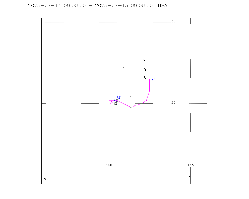
Storm track
-
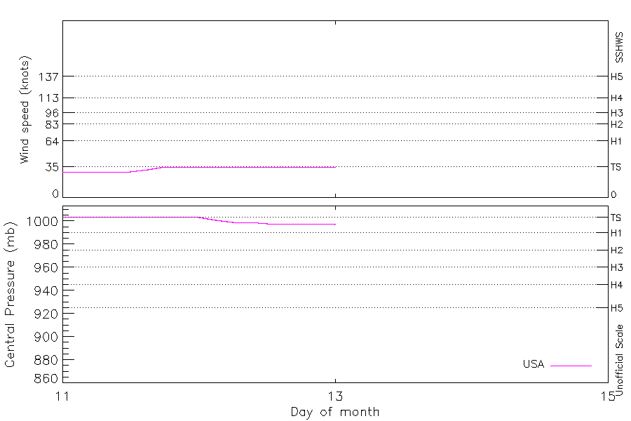
Intensity
-
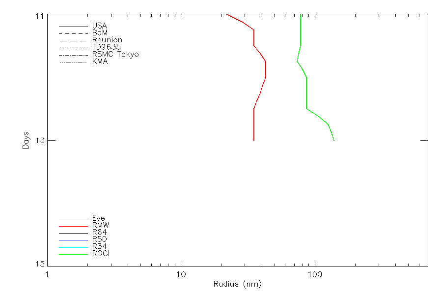
Wind Radii
-
Intensity Data
-
Source Data
-
All data
Summary Information
|
|
| Storm ID |
2025192N25140 |
| Start |
Jul 11 00Z |
| Max Intensity |
51 kt (Jul 13 18Z), 983 mb (Jul 14 00Z) |
| End |
Jul 14 18Z |
| ATCF IDs |
WP062025 |
| Track status |
PROVISIONAL. Track from operational data. This will be upgraded to 'best track' quality after reanalysis |
|
Storm track plot
|
Intensity plots
|
Radial wind information
|
Position and Intensity Table
| BASIN |
ISO_TIME_________ |
NATURE |
LAT |
LON |
USA WIND |
USA PRES |
| |
|
|
degrees north |
degrees east |
kts |
mb |
| WP |
2025-07-11 00:00:00 |
NR |
25.00 |
140.40 |
29 |
1004 |
| WP |
03:00:00 |
NR |
25.00 |
140.10 |
29 |
1004 |
| WP |
06:00:00 |
NR |
25.00 |
140.00 |
29 |
1004 |
| WP |
09:00:00 |
NR |
25.00 |
140.10 |
29 |
1004 |
| WP |
12:00:00 |
NR |
25.10 |
140.20 |
29 |
1004 |
| WP |
15:00:00 |
NR |
25.20 |
140.10 |
32 |
1004 |
| WP |
18:00:00 |
NR |
25.20 |
140.00 |
35 |
1004 |
| WP |
21:00:00 |
NR |
25.20 |
140.20 |
35 |
1004 |
| WP |
2025-07-12 00:00:00 |
NR |
25.20 |
140.50 |
35 |
1003 |
| WP |
03:00:00 |
NR |
25.00 |
140.90 |
35 |
1001 |
| WP |
06:00:00 |
NR |
24.80 |
141.30 |
35 |
999 |
| WP |
09:00:00 |
NR |
24.80 |
141.50 |
35 |
999 |
| WP |
12:00:00 |
NR |
24.90 |
141.60 |
35 |
998 |
| WP |
15:00:00 |
NR |
25.00 |
142.00 |
35 |
998 |
| WP |
18:00:00 |
NR |
25.20 |
142.30 |
35 |
998 |
| WP |
21:00:00 |
NR |
25.80 |
142.40 |
35 |
998 |
| WP |
2025-07-13 00:00:00 |
NR |
26.50 |
142.50 |
35 |
997 |
| WP |
03:00:00 |
NR |
27.00 |
142.70 |
35 |
997 |
| WP |
06:00:00 |
NR |
27.60 |
143.00 |
35 |
997 |
| WP |
09:00:00 |
NR |
28.80 |
143.20 |
37 |
995 |
| WP |
12:00:00 |
NR |
30.20 |
143.30 |
39 |
993 |
| WP |
15:00:00 |
NR |
31.20 |
143.30 |
45 |
989 |
| WP |
18:00:00 |
NR |
32.10 |
143.10 |
51 |
984 |
| WP |
21:00:00 |
NR |
33.00 |
142.60 |
48 |
984 |
| WP |
2025-07-14 00:00:00 |
NR |
34.10 |
142.20 |
45 |
983 |
| WP |
03:00:00 |
NR |
35.40 |
142.30 |
45 |
983 |
| WP |
06:00:00 |
NR |
36.80 |
142.60 |
45 |
983 |
| WP |
09:00:00 |
NR |
38.30 |
142.60 |
42 |
984 |
| WP |
12:00:00 |
NR |
39.80 |
142.70 |
39 |
985 |
| WP |
15:00:00 |
NR |
41.20 |
143.10 |
39 |
989 |
| WP |
18:00:00 |
NR |
42.50 |
143.60 |
39 |
993 |
Source Information
| Agency |
Information |
| USA |
BOTH_tcvitals.txt:Line=5786 |
| TOKYO |
|
| CMA |
|
| HKO |
|
| KMA |
|
| NEWDELHI |
|
| REUNION |
|
| BOM |
|
| NADI |
|
| WELLINGTON |
|
| DS824 |
|
| TD9636 |
|
| TD9635 |
|
| NEUMANN |
|
| MLC |
|
All available IBTrACS Data
| SEASON |
BASIN |
SUBBASIN |
ISO_TIME_________ |
NATURE |
LAT |
LON |
DIST2LAND |
LANDFALL |
IFLAG |
USA AGENCY |
USA ATCF_ID |
USA LAT |
USA LON |
USA WIND |
USA PRES |
USA SSHS |
USA R34 |
USA POCI |
USA ROCI |
USA RMW |
STORM SPEED |
STORM DIR |
| Year |
|
|
|
|
degrees north |
degrees east |
km |
km |
|
|
|
degrees north |
degrees east |
kts |
mb |
1 |
nmile |
mb |
nmile |
nmile |
kts |
degrees |
| 2025 |
WP |
MM |
2025-07-11 00:00:00 |
NR |
25.00 |
140.40 |
1037 |
1025 |
O______________ |
tcvitals |
WP062025 |
25.00 |
140.40 |
29 |
1004 |
-1 |
|
1007 |
90 |
25 |
5 |
270 |
| 2025 |
WP |
MM |
03:00:00 |
NR |
25.00 |
140.10 |
1025 |
1021 |
P______________ |
|
WP062025 |
25.00 |
140.10 |
29 |
1004 |
-1 |
|
1007 |
90 |
33 |
4 |
270 |
| 2025 |
WP |
MM |
06:00:00 |
NR |
25.00 |
140.00 |
1021 |
1021 |
O______________ |
tcvitals |
WP062025 |
25.00 |
140.00 |
29 |
1004 |
-1 |
|
1007 |
90 |
40 |
1 |
320 |
| 2025 |
WP |
MM |
09:00:00 |
NR |
25.00 |
140.10 |
1025 |
1015 |
P______________ |
|
WP062025 |
25.00 |
140.10 |
29 |
1004 |
-1 |
|
1007 |
90 |
40 |
2 |
60 |
| 2025 |
WP |
MM |
12:00:00 |
NR |
25.10 |
140.20 |
1019 |
1005 |
O______________ |
tcvitals |
WP062025 |
25.10 |
140.20 |
29 |
1004 |
-1 |
|
1007 |
90 |
40 |
1 |
0 |
| 2025 |
WP |
MM |
15:00:00 |
NR |
25.20 |
140.10 |
1005 |
1001 |
P______________ |
|
WP062025 |
25.20 |
140.10 |
32 |
1004 |
-1 |
|
1007 |
88 |
45 |
2 |
300 |
| 2025 |
WP |
MM |
18:00:00 |
NR |
25.20 |
140.00 |
1001 |
1001 |
O______________ |
tcvitals |
WP062025 |
25.20 |
140.00 |
35 |
1004 |
0 |
|
1006 |
85 |
50 |
1 |
50 |
| 2025 |
WP |
MM |
21:00:00 |
NR |
25.20 |
140.20 |
1009 |
1009 |
P______________ |
|
WP062025 |
25.20 |
140.20 |
35 |
1004 |
0 |
|
1006 |
93 |
50 |
5 |
90 |
| 2025 |
WP |
MM |
2025-07-12 00:00:00 |
NR |
25.20 |
140.50 |
1021 |
1021 |
O______________ |
tcvitals |
WP062025 |
25.20 |
140.50 |
35 |
1003 |
0 |
|
1006 |
100 |
50 |
7 |
110 |
| 2025 |
WP |
MM |
03:00:00 |
NR |
25.00 |
140.90 |
1059 |
1059 |
P______________ |
|
WP062025 |
25.00 |
140.90 |
35 |
1001 |
0 |
|
1006 |
100 |
48 |
8 |
120 |
| 2025 |
WP |
MM |
06:00:00 |
NR |
24.80 |
141.30 |
1097 |
1097 |
O______________ |
tcvitals |
WP062025 |
24.80 |
141.30 |
35 |
999 |
0 |
|
1006 |
100 |
45 |
5 |
110 |
| 2025 |
WP |
MM |
09:00:00 |
NR |
24.80 |
141.50 |
1107 |
1097 |
P______________ |
|
WP062025 |
24.80 |
141.50 |
35 |
999 |
0 |
|
1006 |
100 |
43 |
3 |
70 |
| 2025 |
WP |
MM |
12:00:00 |
NR |
24.90 |
141.60 |
1102 |
1102 |
O______________ |
tcvitals |
WP062025 |
24.90 |
141.60 |
35 |
998 |
0 |
|
1006 |
100 |
40 |
5 |
70 |
| 2025 |
WP |
MM |
15:00:00 |
NR |
25.00 |
142.00 |
1113 |
1101 |
P______________ |
|
WP062025 |
25.00 |
142.00 |
35 |
998 |
0 |
|
1005 |
123 |
40 |
7 |
65 |
| 2025 |
WP |
MM |
18:00:00 |
NR |
25.20 |
142.30 |
1101 |
1040 |
O______________ |
tcvitals |
WP062025 |
25.20 |
142.30 |
35 |
998 |
0 |
|
1004 |
145 |
40 |
9 |
25 |
| 2025 |
WP |
MM |
21:00:00 |
NR |
25.80 |
142.40 |
1040 |
969 |
P______________ |
|
WP062025 |
25.80 |
142.40 |
35 |
998 |
0 |
|
1004 |
153 |
40 |
13 |
10 |
| 2025 |
WP |
MM |
2025-07-13 00:00:00 |
NR |
26.50 |
142.50 |
969 |
931 |
O______________ |
tcvitals |
WP062025 |
26.50 |
142.50 |
35 |
997 |
0 |
|
1004 |
160 |
40 |
12 |
15 |
| 2025 |
WP |
MM |
03:00:00 |
NR |
27.00 |
142.70 |
920 |
876 |
P______________ |
|
WP062025 |
27.00 |
142.70 |
35 |
997 |
0 |
|
1004 |
160 |
40 |
12 |
20 |
| 2025 |
WP |
MM |
06:00:00 |
NR |
27.60 |
143.00 |
865 |
748 |
O______________ |
tcvitals |
WP062025 |
27.60 |
143.00 |
35 |
997 |
0 |
|
1004 |
160 |
40 |
19 |
10 |
| 2025 |
WP |
MM |
09:00:00 |
NR |
28.80 |
143.20 |
748 |
622 |
P______________ |
|
WP062025 |
28.80 |
143.20 |
37 |
995 |
0 |
|
1004 |
160 |
38 |
26 |
5 |
| 2025 |
WP |
MM |
12:00:00 |
NR |
30.20 |
143.30 |
613 |
528 |
O______________ |
tcvitals |
WP062025 |
30.20 |
143.30 |
39 |
993 |
0 |
|
1004 |
160 |
35 |
24 |
0 |
| 2025 |
WP |
MM |
15:00:00 |
NR |
31.20 |
143.30 |
519 |
435 |
P______________ |
|
WP062025 |
31.20 |
143.30 |
45 |
989 |
0 |
|
1003 |
153 |
28 |
19 |
355 |
| 2025 |
WP |
MM |
18:00:00 |
NR |
32.10 |
143.10 |
426 |
317 |
O______________ |
tcvitals |
WP062025 |
32.10 |
143.10 |
51 |
984 |
0 |
|
1002 |
145 |
20 |
19 |
345 |
| 2025 |
WP |
MM |
21:00:00 |
NR |
33.00 |
142.60 |
317 |
211 |
P______________ |
|
WP062025 |
33.00 |
142.60 |
48 |
984 |
0 |
|
1001 |
143 |
20 |
21 |
340 |
| 2025 |
WP |
MM |
2025-07-14 00:00:00 |
NR |
34.10 |
142.20 |
204 |
134 |
O______________ |
tcvitals |
WP062025 |
34.10 |
142.20 |
45 |
983 |
0 |
|
1000 |
140 |
20 |
24 |
355 |
| 2025 |
WP |
MM |
03:00:00 |
NR |
35.40 |
142.30 |
130 |
128 |
P______________ |
|
WP062025 |
35.40 |
142.30 |
45 |
983 |
0 |
|
1000 |
140 |
20 |
27 |
5 |
| 2025 |
WP |
MM |
06:00:00 |
NR |
36.80 |
142.60 |
143 |
96 |
O______________ |
tcvitals |
WP062025 |
36.80 |
142.60 |
45 |
983 |
0 |
115,170,50,30 |
1000 |
140 |
20 |
29 |
5 |
| 2025 |
WP |
MM |
09:00:00 |
NR |
38.30 |
142.60 |
95 |
48 |
P______________ |
|
WP062025 |
38.30 |
142.60 |
42 |
984 |
0 |
115,170,50,30 |
1000 |
140 |
20 |
30 |
0 |
| 2025 |
WP |
MM |
12:00:00 |
NR |
39.80 |
142.70 |
59 |
59 |
O______________ |
tcvitals |
WP062025 |
39.80 |
142.70 |
39 |
985 |
0 |
115,170,50,30 |
1000 |
140 |
20 |
29 |
5 |
| 2025 |
WP |
MM |
15:00:00 |
NR |
41.20 |
143.10 |
78 |
8 |
P______________ |
|
WP062025 |
41.20 |
143.10 |
39 |
989 |
0 |
|
999 |
115 |
25 |
28 |
15 |
| 2025 |
WP |
MM |
18:00:00 |
NR |
42.50 |
143.60 |
13 |
|
O______________ |
tcvitals |
WP062025 |
42.50 |
143.60 |
39 |
993 |
0 |
|
997 |
90 |
30 |
27 |
15 |