2025
Moderate Tropical Storm UNNAMED (2025198S10090)
IBTrACS version v04r01. Visit
IBTrACS website for data access.
Please direct all questions to the
IBTrACS Q and A forum
Storm track
-
Intensity
-
Wind Radii
-
Intensity Data
-
Source Data
-
All data
Summary Information
|
|
| Storm ID |
2025198S10090 |
| Start |
Jul 16 18Z |
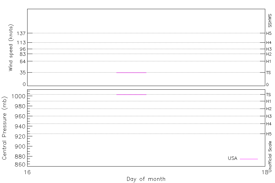
| Max Intensity |
35 kt (Jul 16 21Z) |
| End |
Jul 19 12Z |
| ATCF IDs |
SH012026 |
| Track status |
PROVISIONAL. Track from operational data. This will be upgraded to 'best track' quality after reanalysis |
|
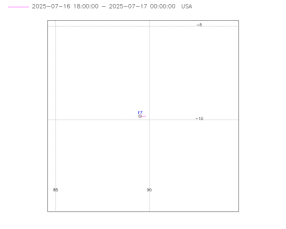
Storm track plot
|
Intensity plots
|
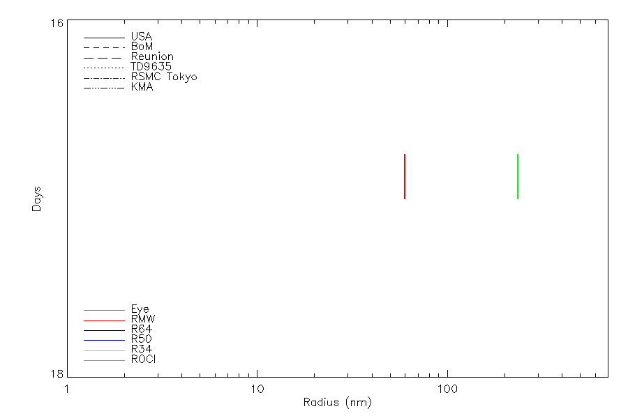
Radial wind information
|
Position and Intensity Table
| BASIN |
ISO_TIME_________ |
NATURE |
LAT |
LON |
USA WIND |
USA PRES |
| |
|
|
degrees north |
degrees east |
kts |
mb |
| SI |
2025-07-16 18:00:00 |
NR |
-9.80 |
89.80 |
35 |
1003 |
| SI |
21:00:00 |
NR |
-9.80 |
89.70 |
35 |
1003 |
| SI |
2025-07-17 00:00:00 |
NR |
-9.80 |
89.50 |
35 |
1003 |
| SI |
03:00:00 |
NR |
-9.80 |
89.20 |
35 |
1003 |
| SI |
06:00:00 |
NR |
-9.90 |
88.80 |
35 |
1003 |
| SI |
09:00:00 |
NR |
-10.00 |
88.40 |
35 |
1003 |
| SI |
12:00:00 |
NR |
-10.10 |
88.10 |
35 |
1003 |
| SI |
15:00:00 |
NR |
-10.10 |
87.80 |
35 |
1003 |
| SI |
18:00:00 |
NR |
-10.30 |
87.60 |
35 |
1003 |
| SI |
21:00:00 |
NR |
-10.70 |
87.40 |
35 |
1003 |
| SI |
2025-07-18 00:00:00 |
NR |
-11.20 |
87.00 |
35 |
1003 |
| SI |
03:00:00 |
NR |
-11.50 |
86.20 |
35 |
1003 |
| SI |
06:00:00 |
NR |
-11.80 |
85.40 |
35 |
1002 |
| SI |
09:00:00 |
NR |
-12.00 |
84.90 |
35 |
1002 |
| SI |
12:00:00 |
NR |
-12.20 |
84.30 |
35 |
1002 |
| SI |
15:00:00 |
NR |
-12.20 |
83.40 |
32 |
1003 |
| SI |
18:00:00 |
NR |
-12.20 |
82.50 |
29 |
1003 |
| SI |
21:00:00 |
NR |
-12.10 |
82.00 |
29 |
1003 |
| SI |
2025-07-19 00:00:00 |
NR |
-12.20 |
81.80 |
29 |
1003 |
| SI |
03:00:00 |
NR |
-12.50 |
81.60 |
29 |
1004 |
| SI |
06:00:00 |
NR |
-13.00 |
81.50 |
29 |
1005 |
| SI |
09:00:00 |
NR |
-13.60 |
81.60 |
29 |
1005 |
| SI |
12:00:00 |
NR |
-14.20 |
81.80 |
29 |
1004 |
Source Information
| Agency |
Information |
| USA |
BOTH_tcvitals.txt:Line=687 |
| TOKYO |
|
| CMA |
|
| HKO |
|
| KMA |
|
| NEWDELHI |
|
| REUNION |
|
| BOM |
|
| NADI |
|
| WELLINGTON |
|
| DS824 |
|
| TD9636 |
|
| TD9635 |
|
| NEUMANN |
|
| MLC |
|
All available IBTrACS Data
| SEASON |
BASIN |
SUBBASIN |
ISO_TIME_________ |
NATURE |
LAT |
LON |
DIST2LAND |
LANDFALL |
IFLAG |
USA AGENCY |
USA ATCF_ID |
USA LAT |
USA LON |
USA WIND |
USA PRES |
USA SSHS |
USA POCI |
USA ROCI |
USA RMW |
STORM SPEED |
STORM DIR |
| Year |
|
|
|
|
degrees north |
degrees east |
km |
km |
|
|
|
degrees north |
degrees east |
kts |
mb |
1 |
mb |
nmile |
nmile |
kts |
degrees |
| 2026 |
SI |
MM |
2025-07-16 18:00:00 |
NR |
-9.80 |
89.80 |
1355 |
1355 |
O______________ |
tcvitals |
SH012026 |
-9.80 |
89.80 |
35 |
1003 |
0 |
1010 |
270 |
70 |
2 |
275 |
| 2026 |
SI |
MM |
21:00:00 |
NR |
-9.80 |
89.70 |
1363 |
1363 |
P______________ |
|
SH012026 |
-9.80 |
89.70 |
35 |
1003 |
0 |
1010 |
270 |
70 |
3 |
270 |
| 2026 |
SI |
MM |
2025-07-17 00:00:00 |
NR |
-9.80 |
89.50 |
1380 |
1380 |
O______________ |
tcvitals |
SH012026 |
-9.80 |
89.50 |
35 |
1003 |
0 |
1010 |
270 |
70 |
5 |
265 |
| 2026 |
SI |
MM |
03:00:00 |
NR |
-9.80 |
89.20 |
1405 |
1405 |
P______________ |
|
SH012026 |
-9.80 |
89.20 |
35 |
1003 |
0 |
1010 |
235 |
73 |
7 |
260 |
| 2026 |
SI |
MM |
06:00:00 |
NR |
-9.90 |
88.80 |
1446 |
1446 |
O______________ |
tcvitals |
SH012026 |
-9.90 |
88.80 |
35 |
1003 |
0 |
1009 |
200 |
75 |
8 |
260 |
| 2026 |
SI |
MM |
09:00:00 |
NR |
-10.00 |
88.40 |
1487 |
1487 |
P______________ |
|
SH012026 |
-10.00 |
88.40 |
35 |
1003 |
0 |
1009 |
200 |
75 |
7 |
255 |
| 2026 |
SI |
MM |
12:00:00 |
NR |
-10.10 |
88.10 |
1520 |
1520 |
O______________ |
tcvitals |
SH012026 |
-10.10 |
88.10 |
35 |
1003 |
0 |
1009 |
200 |
75 |
6 |
255 |
| 2026 |
SI |
MM |
15:00:00 |
NR |
-10.10 |
87.80 |
1547 |
1547 |
P______________ |
|
SH012026 |
-10.10 |
87.80 |
35 |
1003 |
0 |
1010 |
215 |
75 |
5 |
250 |
| 2026 |
SI |
MM |
18:00:00 |
NR |
-10.30 |
87.60 |
1577 |
1577 |
O______________ |
tcvitals |
SH012026 |
-10.30 |
87.60 |
35 |
1003 |
0 |
1010 |
230 |
75 |
7 |
220 |
| 2026 |
SI |
MM |
21:00:00 |
NR |
-10.70 |
87.40 |
1622 |
1622 |
P______________ |
|
SH012026 |
-10.70 |
87.40 |
35 |
1003 |
0 |
1010 |
230 |
75 |
11 |
215 |
| 2026 |
SI |
MM |
2025-07-18 00:00:00 |
NR |
-11.20 |
87.00 |
1691 |
1691 |
O______________ |
tcvitals |
SH012026 |
-11.20 |
87.00 |
35 |
1003 |
0 |
1010 |
230 |
75 |
14 |
235 |
| 2026 |
SI |
MM |
03:00:00 |
NR |
-11.50 |
86.20 |
1781 |
1781 |
P______________ |
|
SH012026 |
-11.50 |
86.20 |
35 |
1003 |
0 |
1010 |
230 |
65 |
17 |
250 |
| 2026 |
SI |
MM |
06:00:00 |
NR |
-11.80 |
85.40 |
1864 |
1864 |
O______________ |
tcvitals |
SH012026 |
-11.80 |
85.40 |
35 |
1002 |
0 |
1010 |
230 |
55 |
14 |
250 |
| 2026 |
SI |
MM |
09:00:00 |
NR |
-12.00 |
84.90 |
1928 |
1928 |
P______________ |
|
SH012026 |
-12.00 |
84.90 |
35 |
1002 |
0 |
1010 |
230 |
55 |
12 |
245 |
| 2026 |
SI |
MM |
12:00:00 |
NR |
-12.20 |
84.30 |
1994 |
1994 |
O______________ |
tcvitals |
SH012026 |
-12.20 |
84.30 |
35 |
1002 |
0 |
1010 |
230 |
55 |
15 |
260 |
| 2026 |
SI |
MM |
15:00:00 |
NR |
-12.20 |
83.40 |
2051 |
2038 |
P______________ |
|
SH012026 |
-12.20 |
83.40 |
32 |
1003 |
-1 |
1010 |
235 |
55 |
18 |
270 |
| 2026 |
SI |
MM |
18:00:00 |
NR |
-12.20 |
82.50 |
2038 |
2023 |
O______________ |
tcvitals |
SH012026 |
-12.20 |
82.50 |
29 |
1003 |
-1 |
1010 |
240 |
55 |
13 |
275 |
| 2026 |
SI |
MM |
21:00:00 |
NR |
-12.10 |
82.00 |
2022 |
2021 |
P______________ |
|
SH012026 |
-12.10 |
82.00 |
29 |
1003 |
-1 |
1009 |
215 |
55 |
7 |
270 |
| 2026 |
SI |
MM |
2025-07-19 00:00:00 |
NR |
-12.20 |
81.80 |
2032 |
2031 |
O______________ |
tcvitals |
SH012026 |
-12.20 |
81.80 |
29 |
1003 |
-1 |
1008 |
190 |
55 |
6 |
230 |
| 2026 |
SI |
MM |
03:00:00 |
NR |
-12.50 |
81.60 |
2064 |
2064 |
P______________ |
|
SH012026 |
-12.50 |
81.60 |
29 |
1004 |
-1 |
1009 |
190 |
60 |
9 |
200 |
| 2026 |
SI |
MM |
06:00:00 |
NR |
-13.00 |
81.50 |
2119 |
2119 |
O______________ |
tcvitals |
SH012026 |
-13.00 |
81.50 |
29 |
1005 |
-1 |
1009 |
190 |
65 |
11 |
180 |
| 2026 |
SI |
MM |
09:00:00 |
NR |
-13.60 |
81.60 |
2187 |
2187 |
P______________ |
|
SH012026 |
-13.60 |
81.60 |
29 |
1005 |
-1 |
1009 |
175 |
65 |
12 |
165 |
| 2026 |
SI |
MM |
12:00:00 |
NR |
-14.20 |
81.80 |
2255 |
|
O______________ |
tcvitals |
SH012026 |
-14.20 |
81.80 |
29 |
1004 |
-1 |
1008 |
160 |
65 |
13 |
160 |