2025
Typhoon WIPHA (2025200N19123)
IBTrACS version v04r01. Visit
IBTrACS website for data access.
Please direct all questions to the
IBTrACS Q and A forum
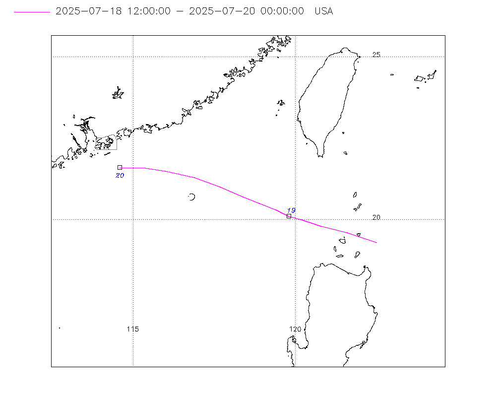
Storm track
-
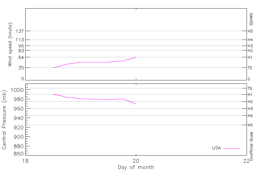
Intensity
-
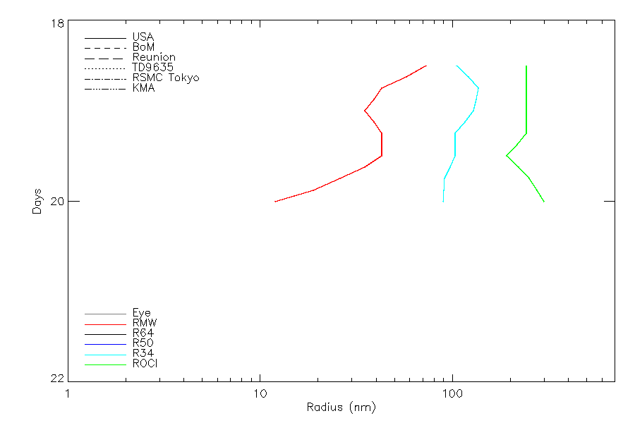
Wind Radii
-
Intensity Data
-
Source Data
-
All data
Summary Information
|
|
| Storm ID |
2025200N19123 |
| Start |
Jul 18 12Z |
| Landfall |
Jul 20 09Z, Jul 22 03Z |
| Max Intensity |
64 kt (Jul 20 00Z), 970 mb (Jul 20 00Z) |
| End |
Jul 22 12Z |
| ATCF IDs |
WP092025 |
| Track status |
PROVISIONAL. Track from operational data. This will be upgraded to 'best track' quality after reanalysis |
|
Storm track plot
|
Intensity plots
|
Radial wind information
|
Position and Intensity Table
| BASIN |
ISO_TIME_________ |
NATURE |
LAT |
LON |
USA WIND |
USA PRES |
| |
|
|
degrees north |
degrees east |
kts |
mb |
| WP |
2025-07-18 12:00:00 |
NR |
19.30 |
122.50 |
35 |
991 |
| WP |
15:00:00 |
NR |
19.60 |
121.60 |
40 |
988 |
| WP |
18:00:00 |
NR |
19.80 |
120.80 |
45 |
984 |
| WP |
21:00:00 |
NR |
20.00 |
120.20 |
48 |
983 |
| WP |
2025-07-19 00:00:00 |
NR |
20.10 |
119.80 |
51 |
981 |
| WP |
03:00:00 |
NR |
20.30 |
119.40 |
51 |
981 |
| WP |
06:00:00 |
NR |
20.50 |
118.90 |
51 |
980 |
| WP |
09:00:00 |
NR |
20.70 |
118.40 |
51 |
980 |
| WP |
12:00:00 |
NR |
21.00 |
117.70 |
51 |
979 |
| WP |
15:00:00 |
NR |
21.30 |
116.90 |
53 |
980 |
| WP |
18:00:00 |
NR |
21.50 |
116.00 |
54 |
981 |
| WP |
21:00:00 |
NR |
21.60 |
115.30 |
59 |
976 |
| WP |
2025-07-20 00:00:00 |
NR |
21.60 |
114.60 |
64 |
970 |
| WP |
03:00:00 |
NR |
21.70 |
113.90 |
64 |
974 |
| WP |
06:00:00 |
NR |
21.80 |
113.20 |
64 |
977 |
| WP |
09:00:00 |
NR |
21.80 |
112.40 |
62 |
979 |
| WP |
12:00:00 |
NR |
21.70 |
111.70 |
60 |
980 |
| WP |
15:00:00 |
NR |
21.60 |
111.20 |
56 |
983 |
| WP |
18:00:00 |
NR |
21.60 |
110.80 |
51 |
986 |
| WP |
21:00:00 |
NR |
21.60 |
110.10 |
48 |
986 |
| WP |
2025-07-21 00:00:00 |
NR |
21.50 |
109.40 |
45 |
985 |
| WP |
03:00:00 |
NR |
21.40 |
109.10 |
45 |
986 |
| WP |
06:00:00 |
NR |
21.30 |
109.00 |
45 |
987 |
| WP |
09:00:00 |
NR |
21.20 |
108.70 |
48 |
986 |
| WP |
12:00:00 |
NR |
21.10 |
108.30 |
51 |
984 |
| WP |
15:00:00 |
NR |
21.00 |
108.00 |
51 |
984 |
| WP |
18:00:00 |
NR |
20.80 |
107.60 |
51 |
984 |
| WP |
21:00:00 |
NR |
20.60 |
107.20 |
48 |
986 |
| WP |
2025-07-22 00:00:00 |
NR |
20.50 |
106.80 |
45 |
987 |
| WP |
03:00:00 |
NR |
20.40 |
106.50 |
40 |
986 |
| WP |
06:00:00 |
NR |
20.30 |
106.20 |
35 |
984 |
| WP |
09:00:00 |
NR |
20.20 |
106.10 |
35 |
987 |
| WP |
12:00:00 |
NR |
20.20 |
106.00 |
35 |
990 |
Source Information
| Agency |
Information |
| USA |
BOTH_tcvitals.txt:Line=8651 |
| TOKYO |
|
| CMA |
|
| HKO |
|
| KMA |
|
| NEWDELHI |
|
| REUNION |
|
| BOM |
|
| NADI |
|
| WELLINGTON |
|
| DS824 |
|
| TD9636 |
|
| TD9635 |
|
| NEUMANN |
|
| MLC |
|
All available IBTrACS Data
| SEASON |
BASIN |
SUBBASIN |
ISO_TIME_________ |
NATURE |
LAT |
LON |
DIST2LAND |
LANDFALL |
IFLAG |
USA AGENCY |
USA ATCF_ID |
USA LAT |
USA LON |
USA WIND |
USA PRES |
USA SSHS |
USA R34 |
USA POCI |
USA ROCI |
USA RMW |
STORM SPEED |
STORM DIR |
| Year |
|
|
|
|
degrees north |
degrees east |
km |
km |
|
|
|
degrees north |
degrees east |
kts |
mb |
1 |
nmile |
mb |
nmile |
nmile |
kts |
degrees |
| 2025 |
WP |
MM |
2025-07-18 12:00:00 |
NR |
19.30 |
122.50 |
102 |
100 |
O______________ |
tcvitals |
WP092025 |
19.30 |
122.50 |
35 |
991 |
0 |
180,170,35,100 |
998 |
280 |
85 |
18 |
290 |
| 2025 |
WP |
MM |
15:00:00 |
NR |
19.60 |
121.60 |
124 |
119 |
P______________ |
|
WP092025 |
19.60 |
121.60 |
40 |
988 |
0 |
195,180,68,115 |
997 |
280 |
68 |
17 |
285 |
| 2025 |
WP |
MM |
18:00:00 |
NR |
19.80 |
120.80 |
134 |
134 |
O______________ |
tcvitals |
WP092025 |
19.80 |
120.80 |
45 |
984 |
0 |
210,190,100,130 |
996 |
280 |
50 |
13 |
285 |
| 2025 |
WP |
MM |
21:00:00 |
NR |
20.00 |
120.20 |
168 |
168 |
P______________ |
|
WP092025 |
20.00 |
120.20 |
48 |
983 |
0 |
205,170,105,130 |
996 |
280 |
45 |
10 |
290 |
| 2025 |
WP |
MM |
2025-07-19 00:00:00 |
NR |
20.10 |
119.80 |
197 |
197 |
O______________ |
tcvitals |
WP092025 |
20.10 |
119.80 |
51 |
981 |
0 |
200,150,110,130 |
996 |
280 |
40 |
9 |
290 |
| 2025 |
WP |
MM |
03:00:00 |
NR |
20.30 |
119.40 |
224 |
224 |
P______________ |
|
WP092025 |
20.30 |
119.40 |
51 |
981 |
0 |
175,125,115,118 |
995 |
280 |
45 |
9 |
295 |
| 2025 |
WP |
MM |
06:00:00 |
NR |
20.50 |
118.90 |
243 |
243 |
O______________ |
tcvitals |
WP092025 |
20.50 |
118.90 |
51 |
980 |
0 |
150,100,120,105 |
994 |
280 |
50 |
10 |
295 |
| 2025 |
WP |
MM |
09:00:00 |
NR |
20.70 |
118.40 |
273 |
245 |
P______________ |
|
WP092025 |
20.70 |
118.40 |
51 |
980 |
0 |
150,100,120,105 |
994 |
250 |
50 |
12 |
295 |
| 2025 |
WP |
MM |
12:00:00 |
NR |
21.00 |
117.70 |
245 |
183 |
O______________ |
tcvitals |
WP092025 |
21.00 |
117.70 |
51 |
979 |
0 |
150,100,120,105 |
993 |
220 |
50 |
15 |
290 |
| 2025 |
WP |
MM |
15:00:00 |
NR |
21.30 |
116.90 |
183 |
135 |
P______________ |
|
WP092025 |
21.30 |
116.90 |
53 |
980 |
0 |
150,90,103,105 |
995 |
255 |
40 |
17 |
290 |
| 2025 |
WP |
MM |
18:00:00 |
NR |
21.50 |
116.00 |
135 |
108 |
O______________ |
tcvitals |
WP092025 |
21.50 |
116.00 |
54 |
981 |
0 |
150,80,85,105 |
997 |
290 |
30 |
15 |
280 |
| 2025 |
WP |
MM |
21:00:00 |
NR |
21.60 |
115.30 |
108 |
84 |
P______________ |
|
WP092025 |
21.60 |
115.30 |
59 |
976 |
0 |
143,85,85,105 |
998 |
318 |
23 |
13 |
275 |
| 2025 |
WP |
MM |
2025-07-20 00:00:00 |
NR |
21.60 |
114.60 |
84 |
67 |
O______________ |
tcvitals |
WP092025 |
21.60 |
114.60 |
64 |
970 |
1 |
135,90,85,105 |
999 |
345 |
15 |
13 |
275 |
| 2025 |
WP |
MM |
03:00:00 |
NR |
21.70 |
113.90 |
69 |
23 |
P______________ |
|
WP092025 |
21.70 |
113.90 |
64 |
974 |
1 |
135,90,85,105 |
999 |
345 |
18 |
13 |
280 |
| 2025 |
WP |
MM |
06:00:00 |
NR |
21.80 |
113.20 |
23 |
0 |
O______________ |
tcvitals |
WP092025 |
21.80 |
113.20 |
64 |
977 |
1 |
135,90,85,105 |
999 |
345 |
20 |
14 |
270 |
| 2025 |
WP |
MM |
09:00:00 |
NR |
21.80 |
112.40 |
0 |
0 |
P______________ |
|
WP092025 |
21.80 |
112.40 |
62 |
979 |
0 |
135,90,85,105 |
999 |
353 |
20 |
14 |
265 |
| 2025 |
WP |
MM |
12:00:00 |
NR |
21.70 |
111.70 |
0 |
0 |
O______________ |
tcvitals |
WP092025 |
21.70 |
111.70 |
60 |
980 |
0 |
135,90,85,105 |
999 |
360 |
20 |
11 |
265 |
| 2025 |
WP |
MM |
15:00:00 |
NR |
21.60 |
111.20 |
0 |
0 |
P______________ |
|
WP092025 |
21.60 |
111.20 |
56 |
983 |
0 |
95,93,93,83 |
999 |
345 |
20 |
8 |
265 |
| 2025 |
WP |
MM |
18:00:00 |
NR |
21.60 |
110.80 |
0 |
0 |
O______________ |
tcvitals |
WP092025 |
21.60 |
110.80 |
51 |
986 |
0 |
55,95,100,60 |
998 |
330 |
20 |
11 |
265 |
| 2025 |
WP |
MM |
21:00:00 |
NR |
21.60 |
110.10 |
0 |
0 |
P______________ |
|
WP092025 |
21.60 |
110.10 |
48 |
986 |
0 |
55,83,90,60 |
998 |
315 |
20 |
13 |
265 |
| 2025 |
WP |
MM |
2025-07-21 00:00:00 |
NR |
21.50 |
109.40 |
0 |
0 |
O______________ |
tcvitals |
WP092025 |
21.50 |
109.40 |
45 |
985 |
0 |
55,70,80,60 |
998 |
300 |
20 |
9 |
260 |
| 2025 |
WP |
MM |
03:00:00 |
NR |
21.40 |
109.10 |
10 |
10 |
P______________ |
|
WP092025 |
21.40 |
109.10 |
45 |
986 |
0 |
55,70,95,60 |
998 |
295 |
25 |
4 |
240 |
| 2025 |
WP |
MM |
06:00:00 |
NR |
21.30 |
109.00 |
23 |
23 |
O______________ |
tcvitals |
WP092025 |
21.30 |
109.00 |
45 |
987 |
0 |
55,70,110,60 |
998 |
290 |
30 |
5 |
245 |
| 2025 |
WP |
MM |
09:00:00 |
NR |
21.20 |
108.70 |
44 |
44 |
P______________ |
|
WP092025 |
21.20 |
108.70 |
48 |
986 |
0 |
55,70,110,60 |
998 |
270 |
30 |
7 |
255 |
| 2025 |
WP |
MM |
12:00:00 |
NR |
21.10 |
108.30 |
45 |
44 |
O______________ |
tcvitals |
WP092025 |
21.10 |
108.30 |
51 |
984 |
0 |
55,70,110,60 |
998 |
250 |
30 |
7 |
250 |
| 2025 |
WP |
MM |
15:00:00 |
NR |
21.00 |
108.00 |
45 |
30 |
P______________ |
|
WP092025 |
21.00 |
108.00 |
51 |
984 |
0 |
65,85,120,63 |
998 |
250 |
30 |
7 |
245 |
| 2025 |
WP |
MM |
18:00:00 |
NR |
20.80 |
107.60 |
30 |
22 |
O______________ |
tcvitals |
WP092025 |
20.80 |
107.60 |
51 |
984 |
0 |
75,100,130,65 |
998 |
250 |
30 |
8 |
245 |
| 2025 |
WP |
MM |
21:00:00 |
NR |
20.60 |
107.20 |
33 |
15 |
P______________ |
|
WP092025 |
20.60 |
107.20 |
48 |
986 |
0 |
75,100,130,65 |
998 |
250 |
30 |
8 |
250 |
| 2025 |
WP |
MM |
2025-07-22 00:00:00 |
NR |
20.50 |
106.80 |
22 |
0 |
O______________ |
tcvitals |
WP092025 |
20.50 |
106.80 |
45 |
987 |
0 |
75,100,130,65 |
998 |
250 |
30 |
7 |
250 |
| 2025 |
WP |
MM |
03:00:00 |
NR |
20.40 |
106.50 |
0 |
0 |
P______________ |
|
WP092025 |
20.40 |
106.50 |
40 |
986 |
0 |
75,90,100,65 |
996 |
185 |
30 |
6 |
250 |
| 2025 |
WP |
MM |
06:00:00 |
NR |
20.30 |
106.20 |
0 |
0 |
O______________ |
tcvitals |
WP092025 |
20.30 |
106.20 |
35 |
984 |
0 |
75,80,70,65 |
994 |
120 |
30 |
4 |
250 |
| 2025 |
WP |
MM |
09:00:00 |
NR |
20.20 |
106.10 |
0 |
0 |
P______________ |
|
WP092025 |
20.20 |
106.10 |
35 |
987 |
0 |
63,83,75,68 |
994 |
125 |
30 |
2 |
240 |
| 2025 |
WP |
MM |
12:00:00 |
NR |
20.20 |
106.00 |
0 |
|
O______________ |
tcvitals |
WP092025 |
20.20 |
106.00 |
35 |
990 |
0 |
50,85,80,70 |
994 |
130 |
30 |
1 |
230 |