2025
Tropical Storm FRANCISCO (2025203N18133)
IBTrACS version v04r01. Visit
IBTrACS website for data access.
Please direct all questions to the
IBTrACS Q and A forum
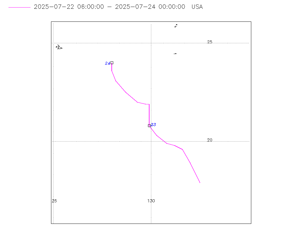
Storm track
-
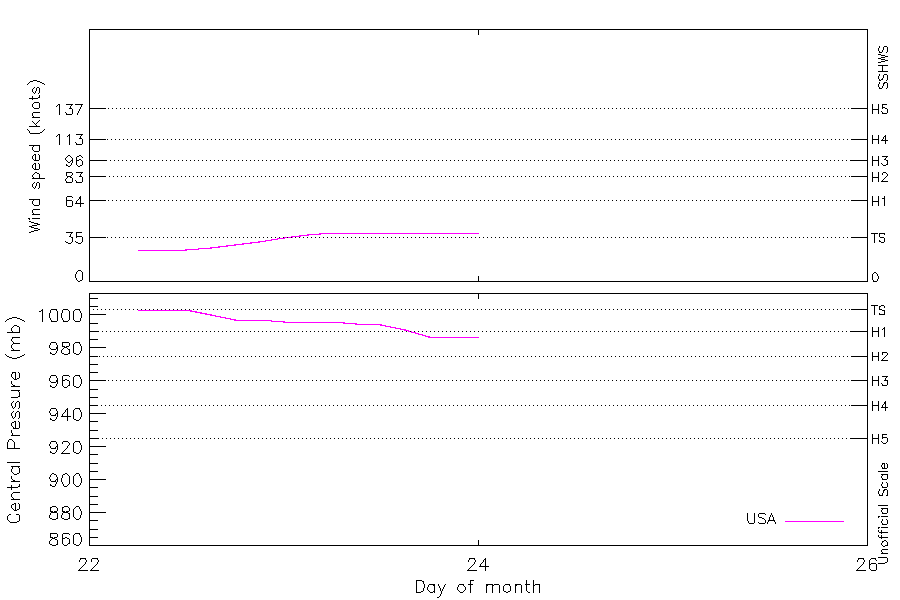
Intensity
-
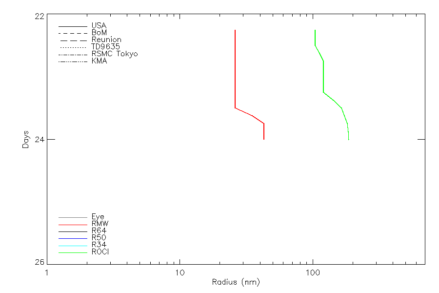
Wind Radii
-
Intensity Data
-
Source Data
-
All data
Summary Information
|
|
| Storm ID |
2025203N18133 |
| Start |
Jul 22 06Z |
| Landfall |
Jul 26 09Z, Jul 26 18Z |
| Max Intensity |
40 kt (Jul 23 12Z), 987 mb (Jul 23 18Z) |
| End |
Jul 27 06Z |
| ATCF IDs |
WP102025 |
| Track status |
US-PROVISIONAL. US track from operational data. Other sources are best track. US sources will be upgraded to 'best track' quality after reanalysis |
|
Storm track plot
|
Intensity plots
|
Radial wind information
|
Position and Intensity Table
| BASIN |
ISO_TIME_________ |
NATURE |
LAT |
LON |
WMO WIND |
WMO PRES |
USA WIND |
USA PRES |
TOKYO WIND |
TOKYO PRES |
CMA WIND |
CMA PRES |
KMA WIND |
KMA PRES |
| |
|
|
degrees north |
degrees east |
kts |
mb |
kts |
mb |
kts |
mb |
kts |
mb |
kts |
mb |
| WP |
2025-07-22 06:00:00 |
TS |
17.90 |
132.60 |
|
1000 |
25 |
1003 |
|
1000 |
25 |
1002 |
29 |
1000 |
| WP |
09:00:00 |
TS |
18.60 |
132.30 |
|
|
25 |
1003 |
|
1000 |
27 |
1001 |
29 |
1000 |
| WP |
12:00:00 |
TS |
19.20 |
131.90 |
|
1000 |
25 |
1003 |
|
1000 |
29 |
1000 |
29 |
1000 |
| WP |
15:00:00 |
TS |
19.60 |
131.50 |
|
|
27 |
1000 |
|
1000 |
29 |
1000 |
29 |
1000 |
| WP |
18:00:00 |
TS |
19.90 |
131.00 |
|
1000 |
29 |
997 |
|
1000 |
29 |
1000 |
29 |
1000 |
| WP |
21:00:00 |
TS |
20.20 |
130.50 |
|
|
32 |
997 |
|
998 |
32 |
998 |
32 |
999 |
| WP |
2025-07-23 00:00:00 |
TS |
20.70 |
130.10 |
35 |
996 |
35 |
996 |
35 |
996 |
34 |
995 |
35 |
998 |
| WP |
03:00:00 |
TS |
21.30 |
130.00 |
|
|
37 |
996 |
35 |
996 |
34 |
995 |
36 |
997 |
| WP |
06:00:00 |
TS |
21.90 |
129.90 |
35 |
996 |
39 |
996 |
35 |
996 |
34 |
995 |
37 |
996 |
| WP |
09:00:00 |
TS |
22.10 |
129.60 |
|
|
39 |
995 |
38 |
995 |
36 |
993 |
39 |
995 |
| WP |
12:00:00 |
TS |
22.30 |
129.30 |
40 |
994 |
39 |
994 |
40 |
994 |
38 |
990 |
41 |
994 |
| WP |
15:00:00 |
TS |
22.70 |
128.80 |
|
|
39 |
991 |
40 |
994 |
38 |
990 |
41 |
994 |
| WP |
18:00:00 |
TS |
23.10 |
128.40 |
40 |
994 |
39 |
987 |
40 |
994 |
38 |
990 |
41 |
994 |
| WP |
21:00:00 |
TS |
23.60 |
128.10 |
|
|
39 |
987 |
40 |
994 |
38 |
990 |
41 |
994 |
| WP |
2025-07-24 00:00:00 |
TS |
24.00 |
128.00 |
40 |
994 |
39 |
987 |
40 |
994 |
38 |
990 |
41 |
994 |
| WP |
03:00:00 |
TS |
24.40 |
128.00 |
|
|
39 |
987 |
40 |
993 |
38 |
990 |
43 |
993 |
| WP |
06:00:00 |
TS |
24.80 |
128.00 |
40 |
992 |
39 |
987 |
40 |
992 |
38 |
990 |
45 |
992 |
| WP |
09:00:00 |
TS |
25.40 |
127.70 |
|
|
37 |
987 |
40 |
991 |
38 |
990 |
46 |
991 |
| WP |
12:00:00 |
TS |
26.00 |
127.10 |
40 |
990 |
35 |
987 |
40 |
990 |
38 |
990 |
47 |
990 |
| WP |
15:00:00 |
TS |
26.50 |
126.10 |
|
|
35 |
989 |
40 |
990 |
36 |
991 |
44 |
991 |
| WP |
18:00:00 |
TS |
26.70 |
125.10 |
40 |
990 |
35 |
991 |
40 |
990 |
34 |
992 |
41 |
992 |
| WP |
21:00:00 |
TS |
26.80 |
124.30 |
|
|
35 |
991 |
38 |
991 |
34 |
992 |
41 |
992 |
| WP |
2025-07-25 00:00:00 |
TS |
26.70 |
123.70 |
35 |
992 |
35 |
991 |
35 |
992 |
34 |
992 |
41 |
992 |
| WP |
03:00:00 |
TS |
26.60 |
123.10 |
|
|
32 |
992 |
|
992 |
34 |
992 |
35 |
992 |
| WP |
06:00:00 |
TS |
26.50 |
122.60 |
|
992 |
29 |
992 |
|
992 |
34 |
992 |
29 |
992 |
| WP |
09:00:00 |
TS |
26.40 |
122.20 |
|
|
27 |
993 |
|
993 |
32 |
993 |
|
|
| WP |
12:00:00 |
TS |
26.30 |
121.80 |
|
994 |
25 |
993 |
|
994 |
29 |
994 |
|
|
| WP |
15:00:00 |
TS |
26.30 |
121.40 |
|
|
25 |
993 |
|
994 |
29 |
994 |
|
|
| WP |
18:00:00 |
TS |
26.30 |
121.10 |
|
994 |
25 |
993 |
|
994 |
29 |
994 |
|
|
| WP |
21:00:00 |
TS |
26.40 |
120.90 |
|
|
25 |
994 |
|
995 |
25 |
995 |
|
|
| WP |
2025-07-26 00:00:00 |
TS |
26.60 |
120.80 |
|
996 |
25 |
994 |
|
996 |
25 |
995 |
|
|
| WP |
03:00:00 |
TS |
26.60 |
120.60 |
|
|
25 |
994 |
|
996 |
25 |
995 |
|
|
| WP |
06:00:00 |
MX |
26.70 |
120.30 |
|
996 |
25 |
994 |
|
996 |
19 |
996 |
|
|
| WP |
09:00:00 |
MX |
26.60 |
120.00 |
|
|
|
|
|
997 |
19 |
996 |
|
|
| WP |
12:00:00 |
MX |
26.60 |
119.70 |
|
998 |
|
|
|
998 |
19 |
996 |
|
|
| WP |
15:00:00 |
NR |
26.60 |
119.70 |
|
|
|
|
|
|
|
|
|
|
| WP |
18:00:00 |
NR |
26.50 |
119.70 |
|
|
|
|
|
|
|
|
|
|
| WP |
21:00:00 |
NR |
26.40 |
119.80 |
|
|
|
|
|
|
|
|
|
|
| WP |
2025-07-27 00:00:00 |
NR |
26.30 |
120.00 |
|
|
|
|
|
|
|
|
|
|
| WP |
03:00:00 |
NR |
26.20 |
120.20 |
|
|
|
|
|
|
|
|
|
|
| WP |
06:00:00 |
NR |
26.10 |
120.40 |
|
|
19 |
995 |
|
|
|
|
|
|
Source Information
| Agency |
Information |
| USA |
BOTH_tcvitals.txt:Line=9596 |
| TOKYO |
bst_all.txt:Line=72328:FRANCISCO:2507 |
| CMA |
CH2025BST.txt:Storm=9:FRANCISCO |
| HKO |
|
| KMA |
kma:2507.txt:FRANCISCO:2507 |
| NEWDELHI |
|
| REUNION |
|
| BOM |
|
| NADI |
|
| WELLINGTON |
|
| DS824 |
|
| TD9636 |
|
| TD9635 |
|
| NEUMANN |
|
| MLC |
|
All available IBTrACS Data
| SEASON |
BASIN |
SUBBASIN |
ISO_TIME_________ |
NATURE |
LAT |
LON |
WMO WIND |
WMO PRES |
WMO AGENCY |
DIST2LAND |
LANDFALL |
IFLAG |
USA AGENCY |
USA ATCF_ID |
USA LAT |
USA LON |
USA WIND |
USA PRES |
USA SSHS |
USA R34 |
USA POCI |
USA ROCI |
USA RMW |
TOKYO LAT |
TOKYO LON |
TOKYO GRADE |
TOKYO WIND |
TOKYO PRES |
TOKYO R50_DIR |
TOKYO R30_DIR |
TOKYO R30_LONG |
TOKYO R30_SHORT |
TOKYO LAND |
CMA LAT |
CMA LON |
CMA CAT |
CMA WIND |
CMA PRES |
KMA LAT |
KMA LON |
KMA CAT |
KMA WIND |
KMA PRES |
KMA R30_DIR |
KMA R30_LONG |
KMA R30_SHORT |
STORM SPEED |
STORM DIR |
| Year |
|
|
|
|
degrees north |
degrees east |
kts |
mb |
|
km |
km |
|
|
|
degrees north |
degrees east |
kts |
mb |
1 |
nmile |
mb |
nmile |
nmile |
degrees north |
degrees east |
1 |
kts |
mb |
|
|
nmile |
nmile |
1 |
degrees north |
degrees east |
1 |
kts |
mb |
degrees north |
degrees east |
|
kts |
mb |
|
nmile |
nmile |
kts |
degrees |
| 2025 |
WP |
MM |
2025-07-22 06:00:00 |
TS |
17.90 |
132.60 |
|
1000 |
tokyo |
984 |
980 |
OOO_O__________ |
tcvitals |
WP102025 |
17.90 |
132.50 |
25 |
1003 |
-1 |
|
1006 |
120 |
30 |
17.60 |
132.90 |
2 |
|
1000 |
0 |
0 |
|
|
0 |
17.90 |
132.40 |
1 |
25 |
1002 |
18.00 |
132.70 |
TD |
29 |
1000 |
|
|
|
17 |
335 |
| 2025 |
WP |
MM |
09:00:00 |
TS |
18.60 |
132.30 |
|
|
|
993 |
990 |
PPP_P__________ |
|
WP102025 |
18.90 |
132.00 |
25 |
1003 |
-1 |
|
1006 |
120 |
30 |
18.40 |
132.70 |
2 |
|
1000 |
0 |
0 |
|
|
|
18.50 |
132.20 |
1 |
27 |
1001 |
18.50 |
132.40 |
TD |
29 |
1000 |
|
|
|
15 |
335 |
| 2025 |
WP |
MM |
12:00:00 |
TS |
19.20 |
131.90 |
|
1000 |
tokyo |
995 |
976 |
OOO_O__________ |
tcvitals |
WP102025 |
19.60 |
131.60 |
25 |
1003 |
-1 |
|
1006 |
120 |
30 |
19.00 |
132.30 |
2 |
|
1000 |
0 |
0 |
|
|
0 |
19.00 |
131.90 |
1 |
29 |
1000 |
19.00 |
132.10 |
TD |
29 |
1000 |
|
|
|
12 |
325 |
| 2025 |
WP |
MM |
15:00:00 |
TS |
19.60 |
131.50 |
|
|
|
976 |
937 |
PPP_P__________ |
|
WP102025 |
19.80 |
131.20 |
27 |
1000 |
-1 |
|
1003 |
130 |
30 |
19.50 |
131.80 |
2 |
|
1000 |
0 |
0 |
|
|
|
19.50 |
131.60 |
1 |
29 |
1000 |
19.50 |
131.70 |
TD |
29 |
1000 |
|
|
|
10 |
310 |
| 2025 |
WP |
MM |
18:00:00 |
TS |
19.90 |
131.00 |
|
1000 |
tokyo |
929 |
893 |
OOO_O__________ |
tcvitals |
WP102025 |
19.90 |
130.80 |
29 |
997 |
-1 |
|
999 |
140 |
30 |
19.80 |
131.20 |
2 |
|
1000 |
0 |
0 |
|
|
0 |
19.90 |
131.20 |
1 |
29 |
1000 |
19.90 |
131.20 |
TD |
29 |
1000 |
|
|
|
11 |
305 |
| 2025 |
WP |
MM |
21:00:00 |
TS |
20.20 |
130.50 |
|
|
|
883 |
860 |
PPP_P__________ |
|
WP102025 |
20.30 |
130.30 |
32 |
997 |
-1 |
|
1000 |
140 |
30 |
20.00 |
130.70 |
2 |
|
998 |
0 |
0 |
|
|
|
20.30 |
130.70 |
1 |
32 |
998 |
20.30 |
130.70 |
TD |
32 |
999 |
|
|
|
12 |
315 |
| 2025 |
WP |
MM |
2025-07-23 00:00:00 |
TS |
20.70 |
130.10 |
35 |
996 |
tokyo |
856 |
856 |
OOO_O__________ |
tcvitals |
WP102025 |
20.80 |
129.90 |
35 |
996 |
0 |
|
1001 |
140 |
30 |
20.40 |
130.40 |
3 |
35 |
996 |
0 |
1 |
350 |
150 |
0 |
20.70 |
130.30 |
2 |
34 |
995 |
20.70 |
130.20 |
TS |
35 |
998 |
225.00 |
108 |
54 |
12 |
335 |
| 2025 |
WP |
MM |
03:00:00 |
TS |
21.30 |
130.00 |
|
|
|
867 |
867 |
PPP_P__________ |
|
WP102025 |
21.40 |
129.90 |
37 |
996 |
0 |
|
1001 |
140 |
30 |
21.10 |
130.20 |
3 |
35 |
996 |
0 |
1 |
350 |
150 |
|
21.30 |
130.00 |
2 |
34 |
995 |
21.30 |
130.00 |
TS |
36 |
997 |
225.00 |
122 |
68 |
12 |
350 |
| 2025 |
WP |
MM |
06:00:00 |
TS |
21.90 |
129.90 |
35 |
996 |
tokyo |
867 |
840 |
OOO_O__________ |
tcvitals |
WP102025 |
21.90 |
129.90 |
39 |
996 |
0 |
|
1001 |
140 |
30 |
21.90 |
130.10 |
3 |
35 |
996 |
0 |
1 |
350 |
150 |
0 |
21.80 |
129.70 |
2 |
34 |
995 |
21.80 |
129.90 |
TS |
37 |
996 |
225.00 |
135 |
81 |
9 |
340 |
| 2025 |
WP |
MM |
09:00:00 |
TS |
22.10 |
129.60 |
|
|
|
830 |
793 |
PPP_P__________ |
|
WP102025 |
21.90 |
129.70 |
39 |
995 |
0 |
|
1001 |
165 |
30 |
22.30 |
129.80 |
3 |
38 |
995 |
0 |
1 |
325 |
150 |
|
22.20 |
129.30 |
2 |
36 |
993 |
22.20 |
129.70 |
TS |
39 |
995 |
225.00 |
143 |
89 |
7 |
305 |
| 2025 |
WP |
MM |
12:00:00 |
TS |
22.30 |
129.30 |
40 |
994 |
tokyo |
793 |
730 |
OOO_O__________ |
tcvitals |
WP102025 |
22.00 |
129.30 |
39 |
994 |
0 |
145,160,185,55 |
1000 |
190 |
30 |
22.50 |
129.50 |
3 |
40 |
994 |
0 |
1 |
300 |
150 |
0 |
22.50 |
128.90 |
2 |
38 |
990 |
22.50 |
129.40 |
TS |
41 |
994 |
225.00 |
151 |
97 |
10 |
305 |
| 2025 |
WP |
MM |
15:00:00 |
TS |
22.70 |
128.80 |
|
|
|
730 |
679 |
PPP_P__________ |
|
WP102025 |
22.50 |
128.70 |
39 |
991 |
0 |
|
999 |
200 |
40 |
22.90 |
129.20 |
3 |
40 |
994 |
0 |
1 |
300 |
150 |
|
22.80 |
128.50 |
2 |
38 |
990 |
22.70 |
128.90 |
TS |
41 |
994 |
225.00 |
157 |
103 |
12 |
315 |
| 2025 |
WP |
MM |
18:00:00 |
TS |
23.10 |
128.40 |
40 |
994 |
tokyo |
679 |
639 |
OOO_O__________ |
tcvitals |
WP102025 |
23.10 |
128.20 |
39 |
987 |
0 |
|
998 |
210 |
50 |
23.30 |
128.80 |
3 |
40 |
994 |
0 |
1 |
300 |
150 |
0 |
23.10 |
128.20 |
2 |
38 |
990 |
23.00 |
128.50 |
TS |
41 |
994 |
225.00 |
162 |
108 |
11 |
325 |
| 2025 |
WP |
MM |
21:00:00 |
TS |
23.60 |
128.10 |
|
|
|
637 |
616 |
PPP_P__________ |
|
WP102025 |
23.60 |
128.00 |
39 |
987 |
0 |
|
998 |
213 |
50 |
23.70 |
128.40 |
3 |
40 |
994 |
0 |
1 |
325 |
150 |
|
23.60 |
128.00 |
2 |
38 |
990 |
23.40 |
128.20 |
TS |
41 |
994 |
225.00 |
162 |
108 |
10 |
340 |
| 2025 |
WP |
MM |
2025-07-24 00:00:00 |
TS |
24.00 |
128.00 |
40 |
994 |
tokyo |
616 |
609 |
OOO_O__________ |
tcvitals |
WP102025 |
24.00 |
128.00 |
39 |
987 |
0 |
|
998 |
215 |
50 |
24.00 |
128.10 |
3 |
40 |
994 |
0 |
1 |
350 |
150 |
0 |
24.10 |
127.90 |
2 |
38 |
990 |
23.90 |
128.00 |
TS |
41 |
994 |
225.00 |
162 |
108 |
8 |
355 |
| 2025 |
WP |
MM |
03:00:00 |
TS |
24.40 |
128.00 |
|
|
|
609 |
605 |
PPP_P__________ |
|
WP102025 |
24.40 |
128.00 |
39 |
987 |
0 |
|
998 |
230 |
92 |
24.30 |
128.10 |
3 |
40 |
993 |
0 |
1 |
350 |
165 |
|
24.40 |
127.90 |
2 |
38 |
990 |
24.30 |
128.00 |
TS |
43 |
993 |
225.00 |
162 |
108 |
8 |
355 |
| 2025 |
WP |
MM |
06:00:00 |
TS |
24.80 |
128.00 |
40 |
992 |
tokyo |
605 |
574 |
OOO_O__________ |
tcvitals |
WP102025 |
24.90 |
127.90 |
39 |
987 |
0 |
|
998 |
245 |
134 |
24.80 |
128.10 |
3 |
40 |
992 |
0 |
2 |
350 |
180 |
0 |
24.80 |
127.90 |
2 |
38 |
990 |
24.80 |
128.00 |
TS |
45 |
992 |
225.00 |
162 |
108 |
11 |
345 |
| 2025 |
WP |
MM |
09:00:00 |
TS |
25.40 |
127.70 |
|
|
|
574 |
531 |
PPP_P__________ |
|
WP102025 |
25.40 |
127.70 |
37 |
987 |
0 |
|
998 |
250 |
134 |
25.50 |
127.70 |
3 |
40 |
991 |
0 |
2 |
350 |
180 |
|
25.30 |
127.70 |
2 |
38 |
990 |
25.50 |
127.70 |
TS |
46 |
991 |
225.00 |
162 |
108 |
14 |
325 |
| 2025 |
WP |
MM |
12:00:00 |
TS |
26.00 |
127.10 |
40 |
990 |
tokyo |
523 |
448 |
OOO_O__________ |
tcvitals |
WP102025 |
26.00 |
127.20 |
35 |
987 |
0 |
|
998 |
255 |
134 |
26.20 |
127.00 |
3 |
40 |
990 |
0 |
2 |
350 |
180 |
0 |
25.80 |
127.20 |
2 |
38 |
990 |
26.10 |
127.00 |
TS |
47 |
990 |
225.00 |
162 |
108 |
17 |
305 |
| 2025 |
WP |
MM |
15:00:00 |
TS |
26.50 |
126.10 |
|
|
|
443 |
363 |
PPP_P__________ |
|
WP102025 |
26.60 |
126.10 |
35 |
989 |
0 |
|
997 |
215 |
95 |
26.60 |
126.00 |
3 |
40 |
990 |
0 |
2 |
350 |
180 |
|
26.20 |
126.50 |
2 |
36 |
991 |
26.50 |
126.00 |
TS |
44 |
991 |
225.00 |
154 |
100 |
20 |
290 |
| 2025 |
WP |
MM |
18:00:00 |
TS |
26.70 |
125.10 |
40 |
990 |
tokyo |
363 |
312 |
OOO_O__________ |
tcvitals |
WP102025 |
26.90 |
124.90 |
35 |
991 |
0 |
|
996 |
175 |
55 |
26.70 |
125.00 |
3 |
40 |
990 |
0 |
2 |
350 |
180 |
0 |
26.40 |
125.60 |
2 |
34 |
992 |
26.70 |
125.00 |
TS |
41 |
992 |
225.00 |
146 |
92 |
16 |
280 |
| 2025 |
WP |
MM |
21:00:00 |
TS |
26.80 |
124.30 |
|
|
|
305 |
261 |
PPP_P__________ |
|
WP102025 |
26.90 |
124.20 |
35 |
991 |
0 |
|
996 |
150 |
53 |
26.80 |
124.30 |
3 |
38 |
991 |
0 |
2 |
325 |
165 |
|
26.50 |
124.70 |
2 |
34 |
992 |
26.80 |
124.30 |
TS |
41 |
992 |
225.00 |
146 |
92 |
12 |
270 |
| 2025 |
WP |
MM |
2025-07-25 00:00:00 |
TS |
26.70 |
123.70 |
35 |
992 |
tokyo |
254 |
215 |
OOO_O__________ |
tcvitals |
WP102025 |
26.70 |
123.70 |
35 |
991 |
0 |
|
996 |
125 |
50 |
26.70 |
123.70 |
3 |
35 |
992 |
0 |
1 |
300 |
150 |
0 |
26.60 |
123.80 |
2 |
34 |
992 |
26.70 |
123.70 |
TS |
41 |
992 |
135.00 |
146 |
92 |
11 |
260 |
| 2025 |
WP |
MM |
03:00:00 |
TS |
26.60 |
123.10 |
|
|
|
209 |
181 |
PPP_P__________ |
|
WP102025 |
26.60 |
123.10 |
32 |
992 |
-1 |
|
996 |
138 |
82 |
26.60 |
123.20 |
3 |
|
992 |
0 |
1 |
|
|
|
26.60 |
123.20 |
2 |
34 |
992 |
26.60 |
123.10 |
TS |
35 |
992 |
135.00 |
|
|
10 |
260 |
| 2025 |
WP |
MM |
06:00:00 |
TS |
26.50 |
122.60 |
|
992 |
tokyo |
176 |
146 |
OOO_O__________ |
tcvitals |
WP102025 |
26.50 |
122.60 |
29 |
992 |
-1 |
|
995 |
150 |
114 |
26.50 |
122.70 |
2 |
|
992 |
0 |
0 |
|
|
0 |
26.60 |
122.70 |
2 |
34 |
992 |
26.50 |
122.60 |
TD |
29 |
992 |
|
|
|
9 |
255 |
| 2025 |
WP |
MM |
09:00:00 |
TS |
26.40 |
122.20 |
|
|
|
146 |
124 |
PPP____________ |
|
WP102025 |
26.30 |
122.10 |
27 |
993 |
-1 |
|
996 |
135 |
114 |
26.30 |
122.20 |
2 |
|
993 |
0 |
0 |
|
|
|
26.50 |
122.30 |
2 |
32 |
993 |
|
|
|
|
|
|
|
|
8 |
250 |
| 2025 |
WP |
MM |
12:00:00 |
TS |
26.30 |
121.80 |
|
994 |
tokyo |
124 |
111 |
OOO____________ |
tcvitals |
WP102025 |
26.20 |
121.70 |
25 |
993 |
-1 |
|
997 |
120 |
114 |
26.20 |
121.80 |
2 |
|
994 |
0 |
0 |
|
|
0 |
26.40 |
121.90 |
1 |
29 |
994 |
|
|
|
|
|
|
|
|
8 |
260 |
| 2025 |
WP |
MM |
15:00:00 |
TS |
26.30 |
121.40 |
|
|
|
122 |
104 |
PPO____________ |
|
WP102025 |
26.20 |
121.30 |
25 |
993 |
-1 |
|
997 |
120 |
95 |
26.20 |
121.30 |
2 |
|
994 |
0 |
0 |
|
|
|
26.40 |
121.50 |
1 |
29 |
994 |
|
|
|
|
|
|
|
|
7 |
275 |
| 2025 |
WP |
MM |
18:00:00 |
TS |
26.30 |
121.10 |
|
994 |
tokyo |
104 |
82 |
OOO____________ |
tcvitals |
WP102025 |
26.30 |
121.00 |
25 |
993 |
-1 |
|
997 |
120 |
75 |
26.30 |
121.00 |
2 |
|
994 |
0 |
0 |
|
|
0 |
26.40 |
121.20 |
1 |
29 |
994 |
|
|
|
|
|
|
|
|
4 |
295 |
| 2025 |
WP |
MM |
21:00:00 |
TS |
26.40 |
120.90 |
|
|
|
82 |
66 |
PPO____________ |
|
WP102025 |
26.40 |
120.90 |
25 |
994 |
-1 |
|
997 |
120 |
75 |
26.40 |
120.90 |
2 |
|
995 |
0 |
0 |
|
|
|
26.50 |
120.90 |
1 |
25 |
995 |
|
|
|
|
|
|
|
|
3 |
320 |
| 2025 |
WP |
MM |
2025-07-26 00:00:00 |
TS |
26.60 |
120.80 |
|
996 |
tokyo |
66 |
49 |
OOO____________ |
tcvitals |
WP102025 |
26.60 |
120.90 |
25 |
994 |
-1 |
|
996 |
120 |
75 |
26.50 |
120.80 |
2 |
|
996 |
0 |
0 |
|
|
0 |
26.60 |
120.70 |
1 |
25 |
995 |
|
|
|
|
|
|
|
|
4 |
305 |
| 2025 |
WP |
MM |
03:00:00 |
TS |
26.60 |
120.60 |
|
|
|
49 |
19 |
PPO____________ |
|
WP102025 |
26.70 |
120.60 |
25 |
994 |
-1 |
|
996 |
120 |
53 |
26.60 |
120.70 |
2 |
|
996 |
0 |
0 |
|
|
|
26.60 |
120.40 |
1 |
25 |
995 |
|
|
|
|
|
|
|
|
5 |
280 |
| 2025 |
WP |
MM |
06:00:00 |
MX |
26.70 |
120.30 |
|
996 |
tokyo |
19 |
0 |
OOO____________ |
tcvitals |
WP102025 |
26.70 |
120.20 |
25 |
994 |
-1 |
|
996 |
120 |
30 |
26.70 |
120.50 |
2 |
|
996 |
0 |
0 |
|
|
0 |
26.50 |
120.20 |
0 |
19 |
996 |
|
|
|
|
|
|
|
|
5 |
270 |
| 2025 |
WP |
MM |
09:00:00 |
MX |
26.60 |
120.00 |
|
|
|
0 |
0 |
PPO____________ |
|
WP102025 |
26.70 |
119.90 |
|
|
-5 |
|
|
|
|
26.60 |
120.10 |
2 |
|
997 |
0 |
0 |
|
|
|
26.40 |
120.00 |
0 |
19 |
996 |
|
|
|
|
|
|
|
|
5 |
265 |
| 2025 |
WP |
MM |
12:00:00 |
MX |
26.60 |
119.70 |
|
998 |
tokyo |
11 |
11 |
OOO____________ |
tcvitals |
WP102025 |
26.70 |
119.80 |
|
|
-5 |
|
|
|
|
26.40 |
119.60 |
2 |
|
998 |
0 |
0 |
|
|
0 |
26.30 |
119.60 |
0 |
19 |
996 |
|
|
|
|
|
|
|
|
2 |
265 |
| 2025 |
WP |
MM |
15:00:00 |
NR |
26.60 |
119.70 |
|
|
|
11 |
0 |
P______________ |
|
WP102025 |
26.60 |
119.70 |
|
|
-5 |
|
|
|
|
|
|
|
|
|
0 |
0 |
|
|
|
|
|
|
|
|
|
|
|
|
|
|
|
|
1 |
0 |
| 2025 |
WP |
MM |
18:00:00 |
NR |
26.50 |
119.70 |
|
|
|
0 |
0 |
O______________ |
tcvitals |
WP102025 |
26.50 |
119.70 |
|
|
-5 |
|
|
|
|
|
|
|
|
|
|
|
|
|
|
|
|
|
|
|
|
|
|
|
|
|
|
|
2 |
145 |
| 2025 |
WP |
MM |
21:00:00 |
NR |
26.40 |
119.80 |
|
|
|
0 |
0 |
P______________ |
|
WP102025 |
26.40 |
119.80 |
|
|
-5 |
|
|
|
|
|
|
|
|
|
|
|
|
|
|
|
|
|
|
|
|
|
|
|
|
|
|
|
3 |
130 |
| 2025 |
WP |
MM |
2025-07-27 00:00:00 |
NR |
26.30 |
120.00 |
|
|
|
19 |
19 |
O______________ |
tcvitals |
WP102025 |
26.30 |
120.00 |
|
|
-5 |
|
|
|
|
|
|
|
|
|
|
|
|
|
|
|
|
|
|
|
|
|
|
|
|
|
|
|
4 |
125 |
| 2025 |
WP |
MM |
03:00:00 |
NR |
26.20 |
120.20 |
|
|
|
41 |
41 |
P______________ |
|
WP102025 |
26.20 |
120.20 |
|
|
-5 |
|
|
|
|
|
|
|
|
|
|
|
|
|
|
|
|
|
|
|
|
|
|
|
|
|
|
|
4 |
125 |
| 2025 |
WP |
MM |
06:00:00 |
NR |
26.10 |
120.40 |
|
|
|
63 |
|
O______________ |
tcvitals |
WP102025 |
26.10 |
120.40 |
19 |
995 |
-1 |
|
998 |
230 |
30 |
|
|
|
|
|
|
|
|
|
|
|
|
|
|
|
|
|
|
|
|
|
|
|
4 |
125 |