2025
Tropical Storm KELI (2025209N12220)
IBTrACS version v04r01. Visit
IBTrACS website for data access.
Please direct all questions to the
IBTrACS Q and A forum
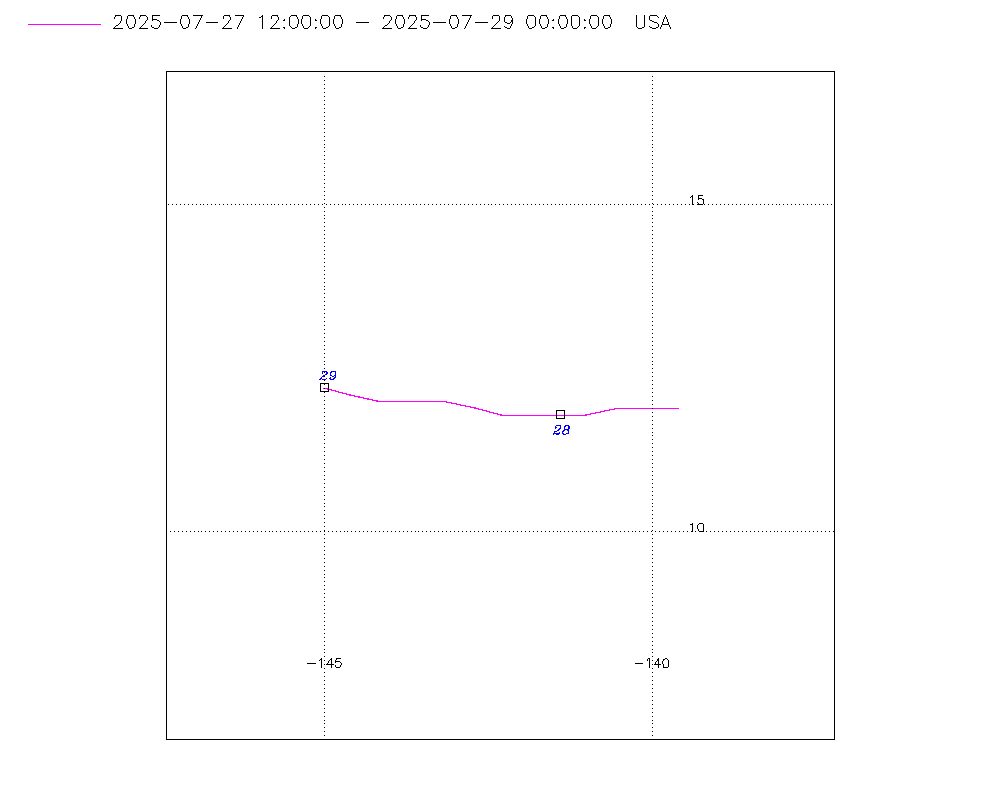
Storm track
-
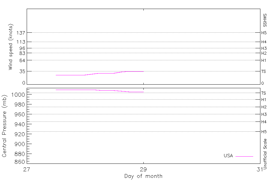
Intensity
-
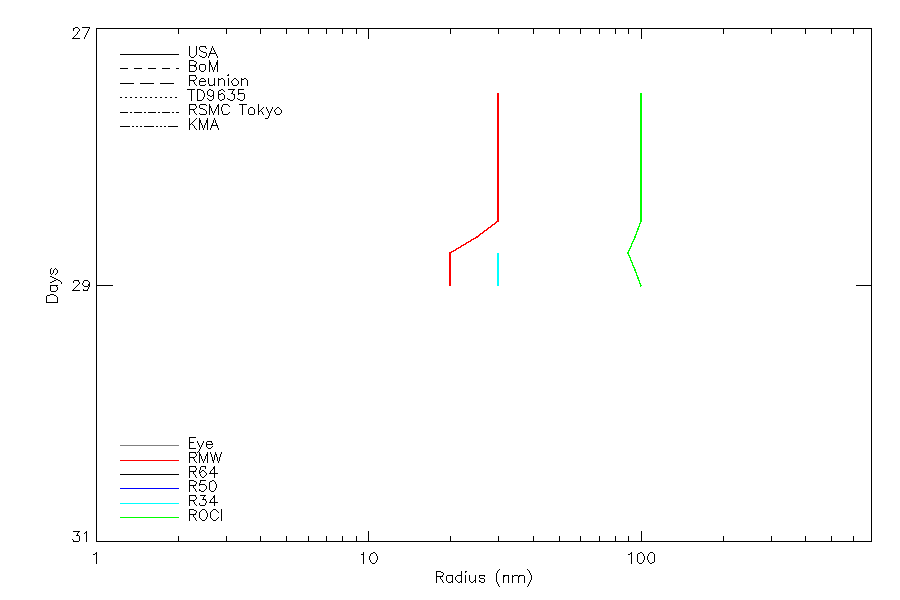
Wind Radii
-
Intensity Data
-
Source Data
-
All data
Summary Information
|
|
| Storm ID |
2025209N12220 |
| Start |
Jul 27 18Z |
| Max Intensity |
45 kt (Jul 29 06Z) |
| End |
Jul 30 12Z |
| ATCF IDs |
CP022025 |
| Track status |
Best track data. |
|
Storm track plot
|
Intensity plots
|
Radial wind information
|
Position and Intensity Table
| BASIN |
ISO_TIME_________ |
NATURE |
LAT |
LON |
WMO WIND |
WMO PRES |
USA WIND |
USA PRES |
| |
|
|
degrees north |
degrees east |
kts |
mb |
kts |
mb |
| EP |
2025-07-27 18:00:00 |
DS |
11.60 |
-140.30 |
25 |
1010 |
25 |
1010 |
| EP |
21:00:00 |
DS |
11.70 |
-140.80 |
|
|
25 |
1010 |
| EP |
2025-07-28 00:00:00 |
DS |
11.70 |
-141.30 |
25 |
1010 |
25 |
1010 |
| EP |
03:00:00 |
DS |
11.70 |
-141.80 |
|
|
28 |
1010 |
| EP |
06:00:00 |
DS |
11.80 |
-142.30 |
30 |
1009 |
30 |
1009 |
| EP |
09:00:00 |
DS |
11.80 |
-142.80 |
|
|
30 |
1009 |
| EP |
12:00:00 |
TS |
11.90 |
-143.20 |
30 |
1008 |
30 |
1008 |
| EP |
15:00:00 |
TS |
12.00 |
-143.60 |
|
|
33 |
1007 |
| EP |
18:00:00 |
TS |
12.10 |
-144.10 |
35 |
1006 |
35 |
1006 |
| EP |
21:00:00 |
TS |
12.20 |
-144.50 |
|
|
38 |
1005 |
| EP |
2025-07-29 00:00:00 |
TS |
12.20 |
-145.00 |
40 |
1004 |
40 |
1004 |
| EP |
03:00:00 |
TS |
12.20 |
-145.50 |
|
|
43 |
1004 |
| EP |
06:00:00 |
TS |
12.30 |
-146.10 |
45 |
1003 |
45 |
1003 |
| EP |
09:00:00 |
TS |
12.40 |
-146.80 |
|
|
45 |
1003 |
| EP |
12:00:00 |
TS |
12.50 |
-147.50 |
45 |
1003 |
45 |
1003 |
| EP |
15:00:00 |
TS |
12.60 |
-148.30 |
|
|
43 |
1004 |
| EP |
18:00:00 |
TS |
12.70 |
-149.20 |
40 |
1004 |
40 |
1004 |
| EP |
21:00:00 |
TS |
12.80 |
-150.10 |
|
|
38 |
1005 |
| EP |
2025-07-30 00:00:00 |
TS |
13.00 |
-151.00 |
35 |
1006 |
35 |
1006 |
| EP |
03:00:00 |
TS |
13.10 |
-151.90 |
|
|
35 |
1007 |
| EP |
06:00:00 |
TS |
13.30 |
-152.80 |
35 |
1007 |
35 |
1007 |
| EP |
09:00:00 |
TS |
13.50 |
-153.70 |
|
|
35 |
1007 |
| EP |
12:00:00 |
TS |
13.60 |
-154.70 |
35 |
1007 |
35 |
1007 |
Source Information
| Agency |
Information |
| USA |
hurdat2-nepac-1949-2025-02272026.txt:Line=32913:KELI::bcp022025.dat |
| TOKYO |
|
| CMA |
|
| HKO |
|
| KMA |
|
| NEWDELHI |
|
| REUNION |
|
| BOM |
|
| NADI |
|
| WELLINGTON |
|
| DS824 |
|
| TD9636 |
|
| TD9635 |
|
| NEUMANN |
|
| MLC |
|
All available IBTrACS Data
| SEASON |
BASIN |
SUBBASIN |
ISO_TIME_________ |
NATURE |
LAT |
LON |
WMO WIND |
WMO PRES |
WMO AGENCY |
DIST2LAND |
LANDFALL |
IFLAG |
USA AGENCY |
USA ATCF_ID |
USA LAT |
USA LON |
USA STATUS |
USA WIND |
USA PRES |
USA SSHS |
USA R34 |
USA POCI |
USA ROCI |
USA RMW |
USA GUST |
USA SEAHGT |
USA SEARAD |
STORM SPEED |
STORM DIR |
| Year |
|
|
|
|
degrees north |
degrees east |
kts |
mb |
|
km |
km |
|
|
|
degrees north |
degrees east |
|
kts |
mb |
1 |
nmile |
mb |
nmile |
nmile |
kts |
ft |
nmile |
kts |
degrees |
| 2025 |
EP |
CP |
2025-07-27 18:00:00 |
DS |
11.60 |
-140.30 |
25 |
1010 |
hurdat_epa |
1786 |
1739 |
O______________ |
hurdat_epa |
CP022025 |
11.60 |
-140.30 |
LO |
25 |
1010 |
-3 |
|
1011 |
100 |
30 |
|
|
|
10 |
275 |
| 2025 |
EP |
CP |
21:00:00 |
DS |
11.70 |
-140.80 |
|
|
|
1734 |
1688 |
P______________ |
|
CP022025 |
11.70 |
-140.80 |
LO |
25 |
1010 |
-3 |
|
1011 |
100 |
30 |
|
|
|
10 |
275 |
| 2025 |
EP |
CP |
2025-07-28 00:00:00 |
DS |
11.70 |
-141.30 |
25 |
1010 |
hurdat_epa |
1688 |
1642 |
O______________ |
hurdat_epa |
CP022025 |
11.70 |
-141.30 |
LO |
25 |
1010 |
-3 |
|
1011 |
100 |
30 |
|
|
|
10 |
275 |
| 2025 |
EP |
CP |
03:00:00 |
DS |
11.70 |
-141.80 |
|
|
|
1642 |
1591 |
P______________ |
|
CP022025 |
11.70 |
-141.80 |
LO |
28 |
1010 |
-3 |
|
1012 |
100 |
30 |
|
|
|
10 |
275 |
| 2025 |
EP |
CP |
06:00:00 |
DS |
11.80 |
-142.30 |
30 |
1009 |
hurdat_epa |
1591 |
1555 |
O______________ |
hurdat_epa |
CP022025 |
11.80 |
-142.30 |
LO |
30 |
1009 |
-3 |
|
1012 |
100 |
30 |
|
|
|
9 |
275 |
| 2025 |
EP |
CP |
09:00:00 |
DS |
11.80 |
-142.80 |
|
|
|
1546 |
1504 |
P______________ |
|
CP022025 |
11.80 |
-142.80 |
LO |
30 |
1009 |
-3 |
|
1012 |
100 |
30 |
|
|
|
9 |
275 |
| 2025 |
EP |
CP |
12:00:00 |
TS |
11.90 |
-143.20 |
30 |
1008 |
hurdat_epa |
1504 |
1462 |
O______________ |
hurdat_epa |
CP022025 |
11.90 |
-143.20 |
TD |
30 |
1008 |
-1 |
|
1011 |
100 |
30 |
40 |
|
|
9 |
280 |
| 2025 |
EP |
CP |
15:00:00 |
TS |
12.00 |
-143.60 |
|
|
|
1462 |
1412 |
P______________ |
|
CP022025 |
12.00 |
-143.60 |
TD |
33 |
1007 |
-1 |
|
1012 |
100 |
25 |
|
|
|
9 |
285 |
| 2025 |
EP |
CP |
18:00:00 |
TS |
12.10 |
-144.10 |
35 |
1006 |
hurdat_epa |
1412 |
1371 |
O______________ |
hurdat_epa |
CP022025 |
12.10 |
-144.10 |
TS |
35 |
1006 |
0 |
30,0,0,30 |
1012 |
100 |
20 |
40 |
|
|
9 |
280 |
| 2025 |
EP |
CP |
21:00:00 |
TS |
12.20 |
-144.50 |
|
|
|
1371 |
1328 |
P______________ |
|
CP022025 |
12.20 |
-144.50 |
TS |
38 |
1005 |
0 |
30,0,0,30 |
1012 |
100 |
20 |
|
|
|
9 |
275 |
| 2025 |
EP |
CP |
2025-07-29 00:00:00 |
TS |
12.20 |
-145.00 |
40 |
1004 |
hurdat_epa |
1328 |
1286 |
O______________ |
hurdat_epa |
CP022025 |
12.20 |
-145.00 |
TS |
40 |
1004 |
0 |
30,0,0,30 |
1011 |
100 |
20 |
45 |
|
|
10 |
275 |
| 2025 |
EP |
CP |
03:00:00 |
TS |
12.20 |
-145.50 |
|
|
|
1286 |
1230 |
P______________ |
|
CP022025 |
12.20 |
-145.50 |
TS |
43 |
1004 |
0 |
30,0,0,30 |
1012 |
100 |
20 |
|
|
|
11 |
275 |
| 2025 |
EP |
CP |
06:00:00 |
TS |
12.30 |
-146.10 |
45 |
1003 |
hurdat_epa |
1230 |
1175 |
O______________ |
hurdat_epa |
CP022025 |
12.30 |
-146.10 |
TS |
45 |
1003 |
0 |
30,0,0,30 |
1012 |
100 |
20 |
45 |
12 |
30,30,30,30 |
12 |
275 |
| 2025 |
EP |
CP |
09:00:00 |
TS |
12.40 |
-146.80 |
|
|
|
1167 |
1105 |
P______________ |
|
CP022025 |
12.40 |
-146.80 |
TS |
45 |
1003 |
0 |
30,0,0,30 |
1012 |
100 |
20 |
|
12 |
30,30,30,30 |
14 |
280 |
| 2025 |
EP |
CP |
12:00:00 |
TS |
12.50 |
-147.50 |
45 |
1003 |
hurdat_epa |
1105 |
1036 |
O______________ |
hurdat_epa |
CP022025 |
12.50 |
-147.50 |
TS |
45 |
1003 |
0 |
30,0,0,30 |
1011 |
100 |
20 |
45 |
12 |
30,30,30,30 |
15 |
275 |
| 2025 |
EP |
CP |
15:00:00 |
TS |
12.60 |
-148.30 |
|
|
|
1036 |
964 |
P______________ |
|
CP022025 |
12.60 |
-148.30 |
TS |
43 |
1004 |
0 |
30,0,0,30 |
1012 |
100 |
20 |
|
12 |
38,30,30,38 |
17 |
275 |
| 2025 |
EP |
CP |
18:00:00 |
TS |
12.70 |
-149.20 |
40 |
1004 |
hurdat_epa |
964 |
902 |
O______________ |
hurdat_epa |
CP022025 |
12.70 |
-149.20 |
TS |
40 |
1004 |
0 |
30,0,0,30 |
1012 |
100 |
20 |
45 |
12 |
45,30,30,45 |
17 |
280 |
| 2025 |
EP |
CP |
21:00:00 |
TS |
12.80 |
-150.10 |
|
|
|
896 |
829 |
P______________ |
|
CP022025 |
12.80 |
-150.10 |
TS |
38 |
1005 |
0 |
30,0,0,30 |
1012 |
100 |
20 |
|
12 |
53,30,30,53 |
18 |
280 |
| 2025 |
EP |
CP |
2025-07-30 00:00:00 |
TS |
13.00 |
-151.00 |
35 |
1006 |
hurdat_epa |
824 |
771 |
O______________ |
hurdat_epa |
CP022025 |
13.00 |
-151.00 |
TS |
35 |
1006 |
0 |
30,0,0,30 |
1011 |
100 |
20 |
45 |
12 |
60,30,30,60 |
18 |
280 |
| 2025 |
EP |
CP |
03:00:00 |
TS |
13.10 |
-151.90 |
|
|
|
765 |
703 |
P______________ |
|
CP022025 |
13.10 |
-151.90 |
TS |
35 |
1007 |
0 |
30,0,0,30 |
1012 |
100 |
20 |
|
12 |
60,30,30,60 |
18 |
280 |
| 2025 |
EP |
CP |
06:00:00 |
TS |
13.30 |
-152.80 |
35 |
1007 |
hurdat_epa |
699 |
651 |
O______________ |
hurdat_epa |
CP022025 |
13.30 |
-152.80 |
TS |
35 |
1007 |
0 |
30,0,0,30 |
1012 |
100 |
20 |
45 |
12 |
60,30,30,60 |
18 |
280 |
| 2025 |
EP |
CP |
09:00:00 |
TS |
13.50 |
-153.70 |
|
|
|
640 |
604 |
P______________ |
|
CP022025 |
13.50 |
-153.70 |
TS |
35 |
1007 |
0 |
35,0,0,30 |
1012 |
100 |
20 |
|
12 |
75,45,30,60 |
19 |
280 |
| 2025 |
EP |
CP |
12:00:00 |
TS |
13.60 |
-154.70 |
35 |
1007 |
hurdat_epa |
602 |
|
O______________ |
hurdat_epa |
CP022025 |
13.60 |
-154.70 |
TS |
35 |
1007 |
0 |
40,0,0,30 |
1012 |
100 |
20 |
45 |
12 |
90,60,30,60 |
19 |
280 |