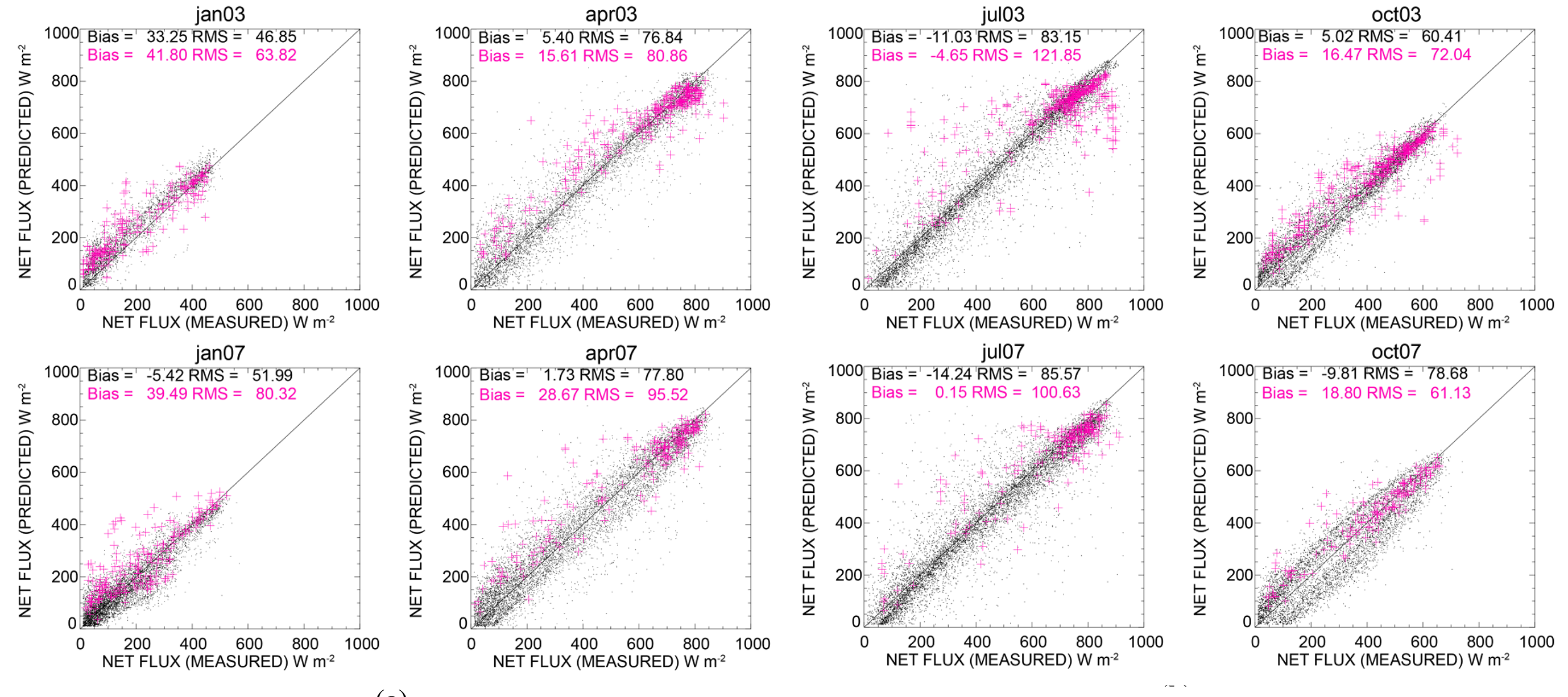
(a) Scatter plots of observed versus GOES-derived net surface SW flux for all eight SURFRAD stations combined, for the months of January, April, July and October 2003. The black dots refer to the GOES and the magenta symbols represent the CERES Model B. The corresponding bias and RMS numbers inset in the figure are in W·m-2; (b) Same as in (a), but for the months of January, April, July and October 2007.
The balance of incoming and outgoing radiation at the Earth’s surface plays a crucial role in how energy and water is exchanged between the surface and the atmosphere. Accurately measuring this net surface radiation is critical for several applications, including weather forecasting and water resource management, and for understanding how changes in greenhouse gas and aerosol concentrations affect the Earth’s climate.
Anand Inamdar of CICS-NC and Pierre Guillevic of the Jet Propulsion Laboratory have developed a method for deriving net surface shortwave radiation data using imagery from the geostationary GOES satellites, in conjunction with several other data sources. The process is adapted from an existing methodology used with data from the Clouds and Earth’s Radiant Energy Scanner (CERES) instruments on the EOS Terra and Aqua satellites. The results are presented in a paper published in the journal Remote Sensing.
Converting the GOES imagery into surface shortwave data involves synthesizing the GOES data with satellite measurements of atmospheric water vapor and aerosols, as well as surface vegetation data based on the normalized difference vegetation index (NDVI) data from MODIS. The results are calibrated using data from the CERES instruments, and results are compared to ground-based radiation measurements from NOAA’s SURFRAD observation network. The GOES results agreed closely with the SURFRAD estimates, with an average bias of less than 5 W/m2 and a root mean square difference of about 70 W/m2.
Inamdar, A., and P. Guillevic, 2015: Net surface shortwave radiation from GOES imagery—product evaluation
using ground-based measurements from SURFRAD. Remote Sensing, 7, 10788. http://dx.doi.org/10.3390/rs70810788