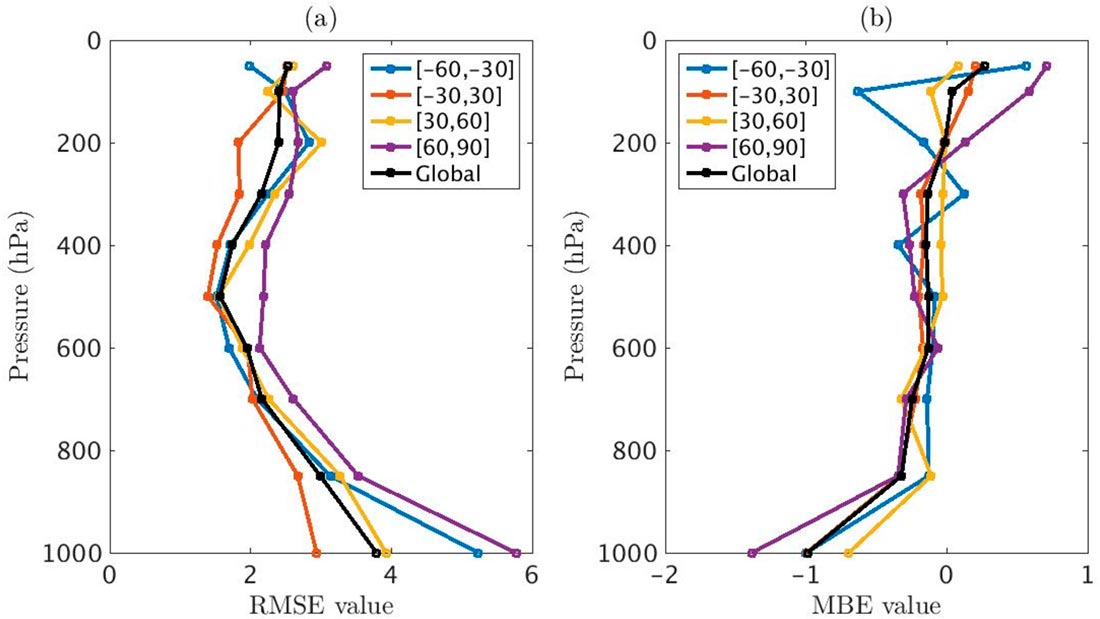
HIRS derived temperature (°C) compared to 2013–2014 (in which data are not used for bias calibration scheme development) radiosonde (1000–400 hPa) and GPS RO (300–50 hPa) profiles for global and latitude bands for (a) RMSE and (b) MBE (HIRS values minus radiosonde or GPS RO values).
CICS-NC’s Jessica Matthews is a coauthor on a paper in Remote Sensing describing an algorithm for deriving vertical temperature and humidity profiles from the High-resolution Infrared Radiation Sounder (HIRS) observations. This effort represents a key step in the developing a climate data record (CDR)—a high-quality, long-term dataset suitable for climate applications.
The team employed neural networks, which can model the non-linear relationship between the radiances observed by the instrument and the variables being retrieved. The neural network algorithm is also fast, resulting in relatively minimal computational requirements. Different neural networks are used for three different surface elevations.
The algorithm also employs a two-tier cloud screening methodology using data from another CDR (PATMOS-x). Calibration is done using data from radiosondes, GPS radio occultation measurements, and NOAA’s U.S. Climate Reference Network.
The authors also note that continuing increases in atmospheric carbon dioxide concentrations affect the measurements provided by HIRS instruments, so the algorithm must account for these effects.
The authors report that global mean biases are generally small, within ±0.3°C for temperature and ±2g/kg for specific humidity.
Shi, L., J. L. Matthews, S.-p. Ho, Q. Yang, and J. J. Bates, 2016: Algorithm development of temperature and humidity profile retrievals for long-term HIRS observations. Remote Sensing, 8, 280. http://dx.doi.org/10.3390/rs8040280