Search Results for: "remote sensing"
Oct 30, 2014
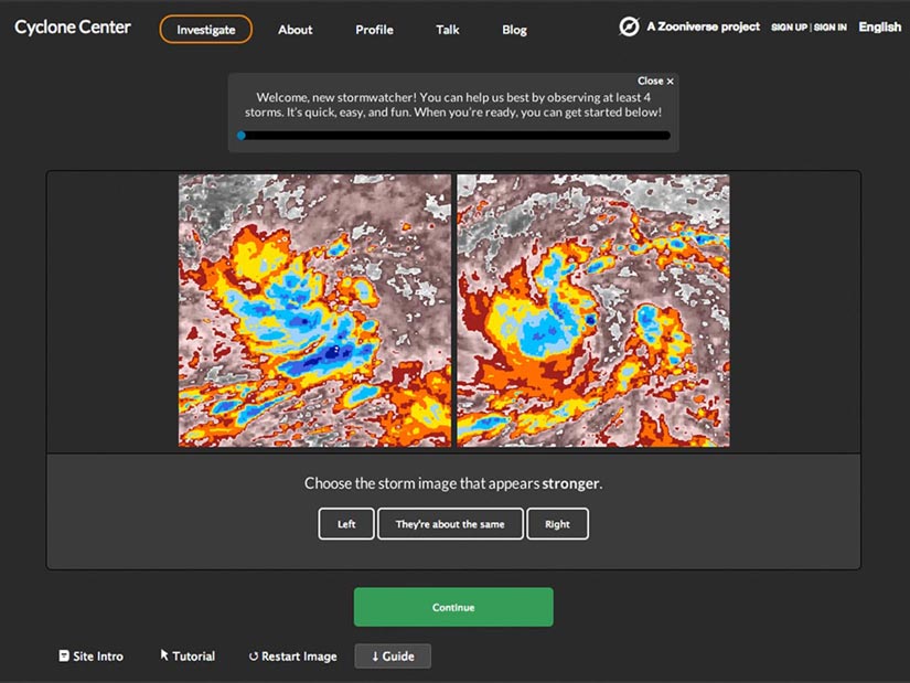
Cyclone Center: New Paper, Website Updates
“We don’t understand all the mysteries of tropical cyclones” That’s the motivation behind the Cyclone Center project, which is soliciting help from “citizen scientists” around…→
Apr 16, 2013
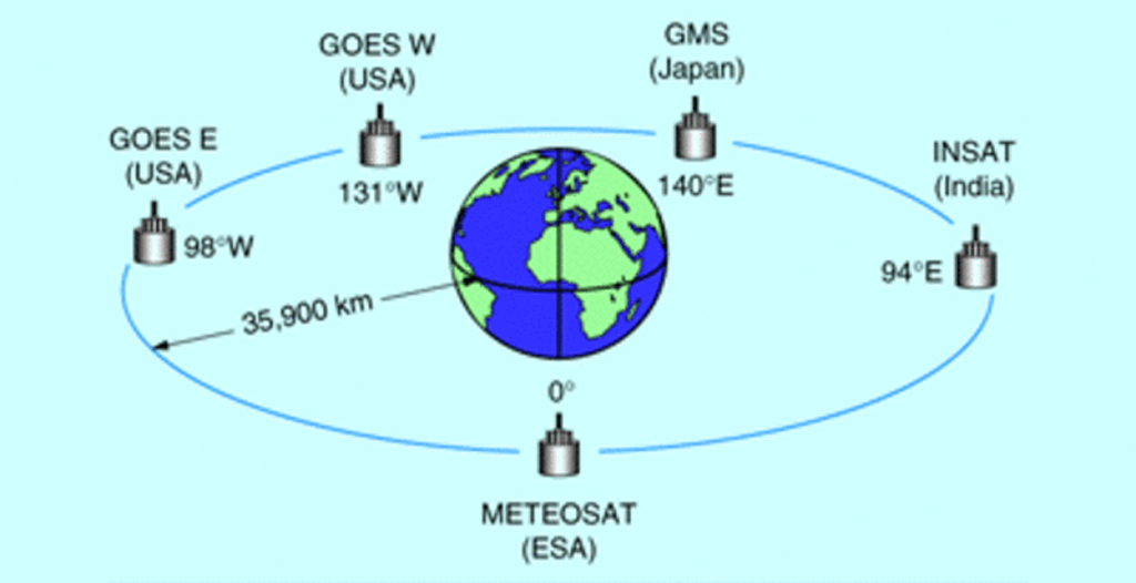
Calibration and Validation of Geostationary Satellite Visible Imagery
Meteorological satellites operating in geostationary orbits around the Earth (Fig. 1) provide us with observations of the Earth’s surface and clouds since the early 1970’s.…→

May 31, 2019
NC State Climate Research Institute to Host NOAA Cooperative Institute
NCICS to Host NOAA Cooperative Institute NCICS will host the Asheville location of the new Cooperative Institute for Satellite Earth System Studies, which will be…→
Dec 10, 2024
NCICS at AGU 2024
Twenty-one NCICS staff are contributing to presentations, posters, town halls, and other activities at the 2024 American Geophysical Union Annual Meeting, December 9–13 in Washington,…→
Oct 12, 2016
CICS at Fall AGU 2014
CICS at Fall AGU 2014 Pa A11A-3007Long-Term Large-Scale Bias-Adjusted Precipitation Estimates at High Spatial and Temporal Resolution Derived from the National Mosaic and Multi-Sensor QPE…→
Oct 13, 2016
NASA DEVELOP Students Visit NCEI
NASA DEVELOP Students Visit NCEI MARCH 28, 2013 Background The NASA DEVELOP Program at Wise, Virginia focuses on environmental research conducted through the use of…→

Laura Stevens
Laura Stevens provides primary scientific and technical expertise for NOAA and the National Climate Assessment (NCA). This includes the development of climate data analysis products,…→

James Anheuser
Dr. James Anheuser joined NCICS in January 2024 as a research scholar in software engineering, working with the National Climate Assessment Technical Support Unit. Dr.…→
Jul 13, 2015
Calibrating Satellite Data to Better Understand Clouds
The International Satellite Cloud Climatology Project (ISCCP) collects and analyzes satellite data in order to advance our understanding of clouds—how they are distributed around the…→
Oct 29, 2014
Validation of Land Surface Temperature products derived from the Visible Infrared Imaging Radiometer
Satellites provide critical weather and climate data, including measurements of surface temperature, but extracting temperature information from raw satellite data requires sophisticated data-processing algorithms. Jim…→