Category: Expertise: Observing Systems
Apr 16, 2013
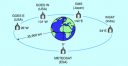
Calibration and Validation of Geostationary Satellite Visible Imagery
Meteorological satellites operating in geostationary orbits around the Earth (Fig. 1) provide us with observations of the Earth’s surface and clouds since the early 1970’s.…
Apr 5, 2013
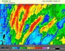
RADAR based High-Resolution Precipitation
The best precipitation dataset in current production in the US provides data every one to three hours, on a scale of roughly 4 km (one…
Apr 3, 2013
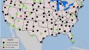
Soil Climate Observations
The U.S. Climate Reference Network (USCRN) is a network of climate-monitoring stations maintained and operated by the National Oceanic and Atmospheric Administration (NOAA) to provide…
Feb 10, 2013
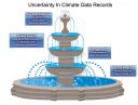
Uncertainty Quantification
Policy makers rely on climate observations and model predictions that inherently contain uncertainties. Accurate characterization of these uncertainties is necessary to make well-informed decisions. Observations…
Feb 10, 2013
Geostationary Surface Albedo
Surface albedo is the fraction of incoming solar radiation reflected by the land surface, and therefore is a sensitive indicator of environmental changes. Its value…