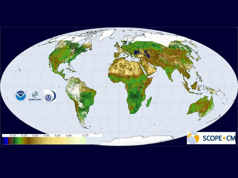
Broadband black sky albedo spatial composite product for the period 1-10 May 2001.
Surface albedo is the fraction of incoming solar radiation reflected by the land surface, and therefore is a sensitive indicator of environmental changes. Its value changes in space and time, depending on both natural processes (vegetation growth, rain, snowfall, wildfires) and human activities (deforestation, crop harvest, urbanization).
Surface albedo is identified as an Essential Climate Variable (ECV) by the Global Climate Observing System (GCOS). NCEI/CICS-NC is implementing the GSA algorithm for GOES visible data to contribute to an international effort in collaboration with The European Organization for the Exploitation of Meteorological Satellites (EUMETSAT) and the Japan Meteorological Agency (JMA). This activity supports the Sustained, Coordinated Processing of Environmental Satellite Data for Climate Monitoring (SCOPE-CM). It signifies the first attempt to use the same core algorithm across internationally operated geostationary satellites to produce a near-global Climate Data Record for this variable.
Currently, the GSA algorithm generates products operationally at EUMETSAT using geostationary data from satellites at 0° and 63°E and at JMA using 140°E geostationary data. To create the stitched global Level 3 product as illustrated in the figure, Jessica Matthews, of CICS-NC, is tasked with managing the implementation of the algorithm for GOES-E (75°W) and GOES-W (135°W), on behalf of NCEI.
Four years of albedo products over North America and South America (from GOES observations) have been processed and sent to EUMETSAT to be combined with their and JMA’s data holdings for the same time period to comprise the near-global record (next phase will include the polar observations). This accomplishment signified the completion of the first phase of multi-year activity to reprocess all the geosynchronous satellite holdings for the modern era and generate a common surface albedo product. To this end, CICS-NC undertook the largest reprocessing effort to date at NCEI, and we are now able to improve the understanding of historical environmental observations with this advanced processing technology. The next phase will continue and extend the collaboration to improve the algorithm’s handling of calibration and cloud masks as well as to explore different temporal resolutions and formats to best serve data users in climate science.
Alessio Lattanzio, Jörg Schulz, Jessica Matthews, Arata Okuyama, Bertrand Theodore, John J. Bates, Kenneth R. Knapp, Yuki Kosaka, Lothar Schüller, 2012. Land Surface Albedo from Geostationary Satellites: a multi-agency collaboration within SCOPE-CM, Bull. Am. Met. Soc., doi: 10.1175/BAMS-D-11-00230.1