Category: Expertise: Observing Systems
Aug 21, 2015
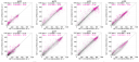
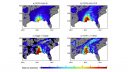
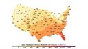
Net Surface Shortwave Radiation from GOES Imagery—Product Evaluation Using Ground-Based Measurements from SURFRAD
The balance of incoming and outgoing radiation at the Earth’s surface plays a crucial role in how energy and water is exchanged between the surface…
Jul 16, 2015
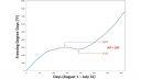
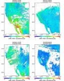
Extending the Soil Moisture Record
Long-term data on soil moisture can be invaluable for making decisions about agricultural irrigation, understanding and predicting drought, and improving global climate models. Unfortunately, accurate…
Jul 13, 2015
Calibrating Satellite Data to Better Understand Clouds
The International Satellite Cloud Climatology Project (ISCCP) collects and analyzes satellite data in order to advance our understanding of clouds—how they are distributed around the…
Apr 10, 2015
Winter Severity and Frost Depth in a Warming Climate
In many areas of the country, proper building design and construction depend on accurate expectations of how deeply the ground will freeze in the winter.…
Feb 27, 2015
PERSIANN: Climate Data Record and Smartphone App
The Center for Hydrometeorology and Remote Sensing (CHRS) at the University of California, Irvine, a partner of CICS-NC, has developed a smartphone/tablet application called “RainMapper”…
Oct 29, 2014
Validation of Land Surface Temperature products derived from the Visible Infrared Imaging Radiometer
Satellites provide critical weather and climate data, including measurements of surface temperature, but extracting temperature information from raw satellite data requires sophisticated data-processing algorithms. Jim…
Oct 29, 2014
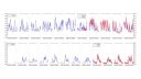
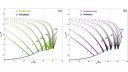
The Impact of Raindrop Collisional Processes on the Polarimetric Radar Variables
Olivier Prat of CICS-NC and co-author Matthew Kumjian recently examined the complex, very small-scale processes of rainfall by combining model simulations of rainfall microphysics with…
Oct 2, 2014
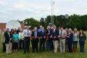
New Weather Station at Isothermal Community College
A new weather station on the campus of Isothermal Community College in Spindale, NC, fills a critical gap in data coverage for southwestern North Carolina.…
Dec 13, 2013
CICS-NC Develops An Interactive Map To Engage With NOAA Climate Data Users
The U.S. Climate Reference Network (USCRN) is a network of climate monitoring stations maintained and operated by NOAA to provide climate-science-quality measurements of air temperature…
Oct 1, 2013
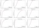
Quantifying Tropical Cyclone Rainfall
Tropical cyclones (TCs) constitute one of the major natural disasters around the world as well as an important source of fresh water over areas prone…