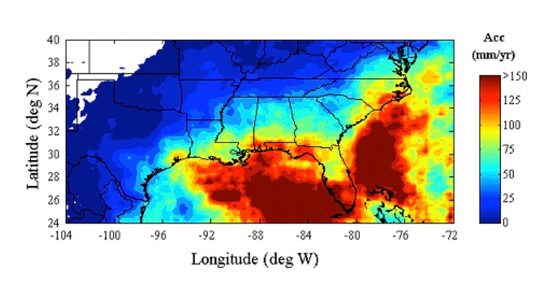
Seasonal contribution of tropical cyclones over the Southeastern United States for 1998-2009.
The precipitation climatology of the Southeastern United States spans a very broad spectrum of precipitation regimes. A warm season that is characterized by isolated thunderstorms, mesoscale convective systems, and tropical cyclones, and a winter season characterized by widespread frontal rain, ice, and snowfall. Each of these types of precipitation system impacts regional hydrology in very different ways, and are associated with a large variety of natural hazards.
The primary goal of Olivier Prat, CICS-NC, is to focus on the analysis of long term remotely sensed datasets in order to assess precipitation patterns and hydro-climatic extremes. Using all available satellite precipitation products (TPR 2A25 and TMPA 3B42) from the Tropical Rainfall Measuring Mission (TRMM) derived rainfall characteristic (yearly, seasonal, diurnal, extreme events) at fine scales. Results showed that tropical cyclones account for about 8-12% of the seasonal (June to November) precipitation totals and up to 15-20% for areas located near the coasts (Upper Figure).
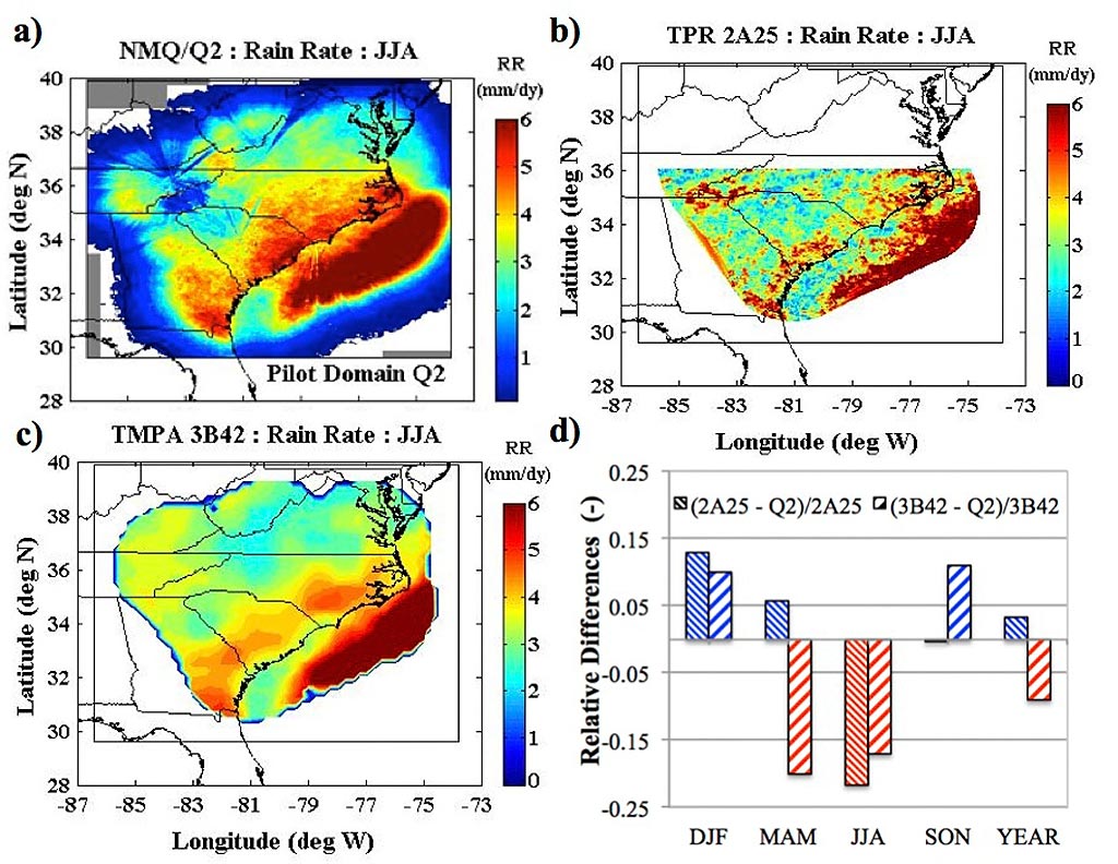
Average Summer (JJA) rainfall derived from: a) NMQ/Q2 (1km), b) TPR 2A25 (5km), and c) TMPA 3B42 (25km). d) Seasonal differences between TPR 2A25 and NMQ/Q2 and TMPA 3B42 and NMQ/Q2.
Furthermore, Olivier Prat, CICS-NC, in collaboration with Brian Nelson, NOAA’s National Centers for Environmental Information (NCEI), uses ground based precipitation estimates derived from the National Mosaic and Multi-Sensor Quantitative precipitation Estimates (NMQ/Q2). A comparison of ground based (Lower Figure) and satellite QPE (Lower Figure: b-c) is provided for a pilot domain centered over the Carolinas. Results indicate that satellite estimates (TPR and TMPA) tend to produce higher daily average rain rates than NMQ/Q2 during the cold season (or transition to/from the cold season) (Lower Figure: 2d). On the contrary, rainfall retrieved from NMQ/Q2 is higher than satellite estimates during the warm season (or transition to/from the warm season) because the higher spatial and temporal resolution of NMQ/Q2 allows capturing short-lived localized precipitation events that occur during the warm season.
The domain of study is currently extended to the continental United States. The next step will build upon the NMQ/Q2 reanalysis effort currently underway by Scott Stevens, CICS-NC. This work represents a first step toward the development of rainfall climatologies at high spatial and temporal resolution. The ultimate goal is to provide high-resolution precipitation estimates for hydrological applications and to derive trends in the evolution of precipitation patterns over time.
Prat, O.P., and B.R. Nelson, 2013. Precipitation contribution of tropical cyclones in the Southeastern United States from 1998 to 2009 using TRMM satellite data. Journal of Climate. 26, 1047-1062. doi: 10.1175/JCLI-D-11-00736.1