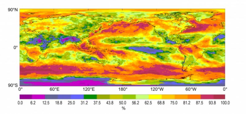
NOAA’s National Centers for Environmental Information recently announced the release of an updated version of the International Satellite Cloud Climatology Project (ISCCP) dataset. ISCCP uses information from multiple satellites to develop a data set of cloud cover, allowing scientists to study the global distribution of clouds, their properties, and how cloud cover changes over daily, seasonal, yearly, and multi-year timeframes. Clouds have a significant impact on the planet’s water cycle and they both reflect incoming solar energy and absorb infrared energy being radiated back from the surface, all of which makes cloud data particularly important for understanding changes in the Earth’s climate. This new “H Series” data offers several improvements, including an expanded period of record, higher-resolution data, and new value-added products.
CICS-NCs Anand Inamdar played a critical role in facilitating the transition of the ISCCP data from NASA’s Goddard Institute for Space Studies to NCEI and has made significant scientific contributions to the efforts to update and reprocess the data. ISCCP data is assembled from multiple generations of satellites, including both low-Earth-orbit polar satellites and weather satellites in higher geostationary orbits. These satellites use different instruments, measuring different quantities, from different positions and heights above the Earth. As a result, much of Anand’s work has focused on the meticulous data calibration efforts required to compile an accurate and consistent record of cloud cover information from these different sources. This includes comparing time series of ISCCP-implemented calibration coefficients for geostationary satellites with those derived from the Advanced Very High Resolution Radiometer (AVHRR) PATMOS-x reference for both the base period (1983-2009) and the extended period (2010-2015). Anand has also worked on the creation of tables to convert raw data into estimates of radiance and brightness temperatures.
The project also requires extensive quality control (QC) efforts to ensure the validity of the data. Anand developed software packages to automate QC of the AVHRR Global Area Coverage (GAC) data, which are core inputs to the next generation H-series ISCCP cloud products. He also was responsible for manual visual inspection of the ISCCP B1 and AVHRR GAC imagery.
Efforts are still ongoing, as the ISCCP team at NCEI is currently working to add 2015 data to the ISCCP Climate Data Record.
For more about the new ISCCP H series data, including links to access the data, see the NOAA NCEI web story.
For more about some of Anand’s ISCCP-related research, see Calibrating Satellite Data to Better Understand Clouds and Calibration and Validation of Geostationary Satellite Visible Imagery.
